Equal Weighted Analyzes
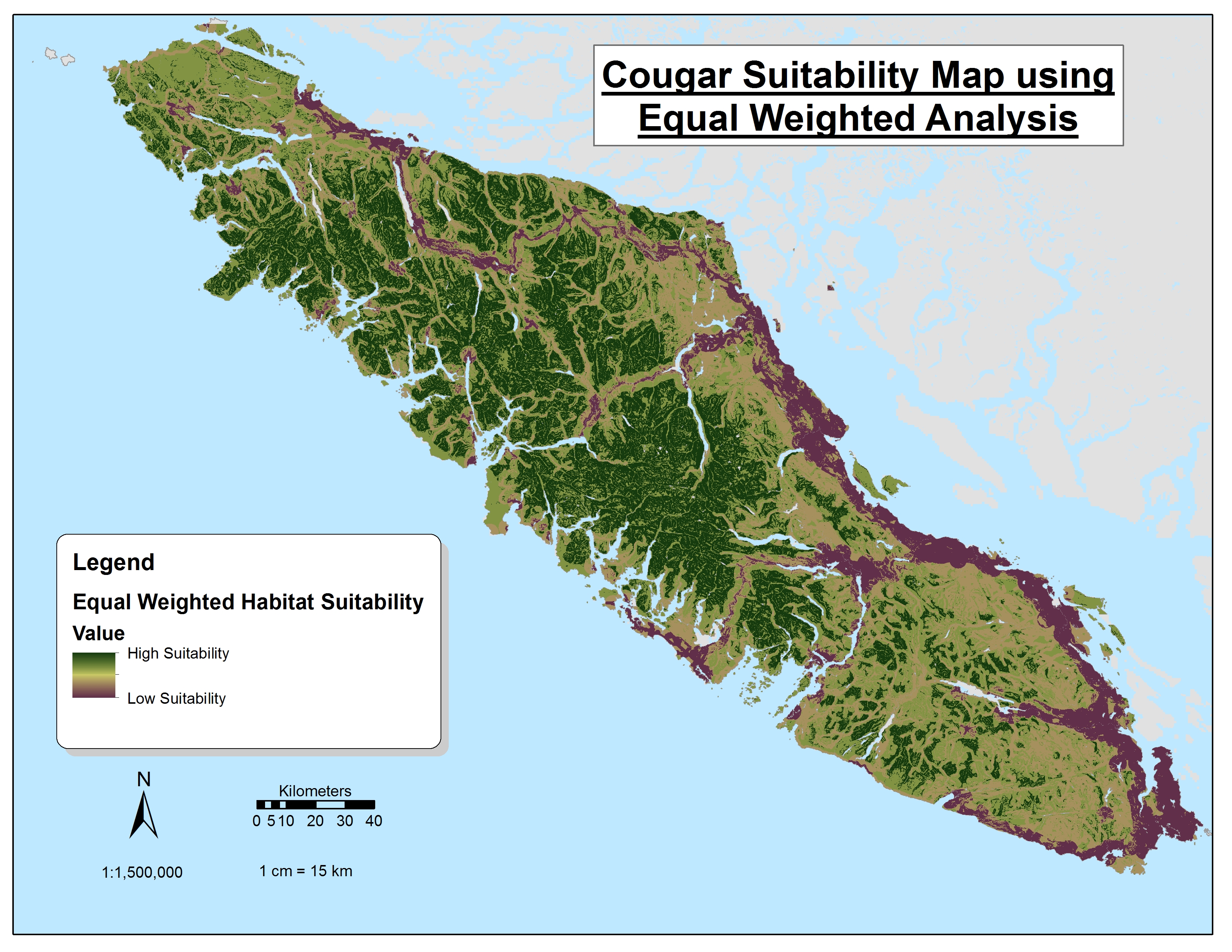 Figure 3: Equal weighted Cougar suitability map:
Our Cougar suitability was dictated in this map with equally weighted layers of slopes above 15 degrees, road & highway buffer, population center buffers, broad leaf & mixed forests. The 3 anthropocentric layers (road, highway, pop centers) were given suitability values of zero with suitability increasing with distance from buffers. As such, the map shows lowest variability on these regions, mainly along the heavily populated east coast. Slopes and broad leaf forests dominated the interior of the island and due to their high suitability, allowed the interior of the island to be most suitable, especially in the mountainous regions.
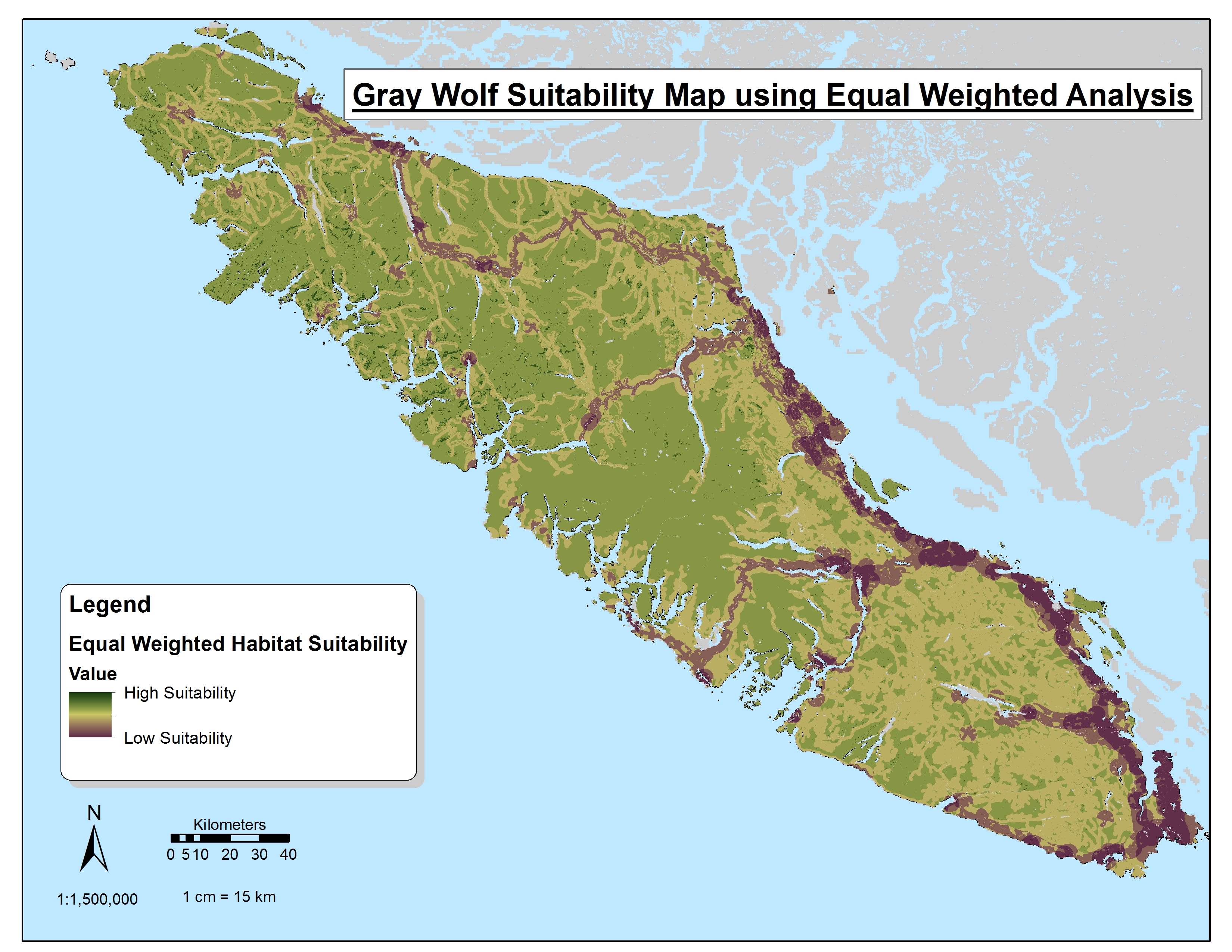 Figure 4: Equal weighted Wolf suitability map:
Wolf suitability functions much like Cougar suitability with the same layers except different buffers set for the anthropocentric layers are chosen as dictated by research and slopes are not represented. Thus, Wolf suitability offers a far less extreme version than that of the other land predator, cougar, as slopes are not representative making the interior less suitable. However, the interior of the island remains most suitable area due to lack of human influence and presence of mixed and broad leaf forests.
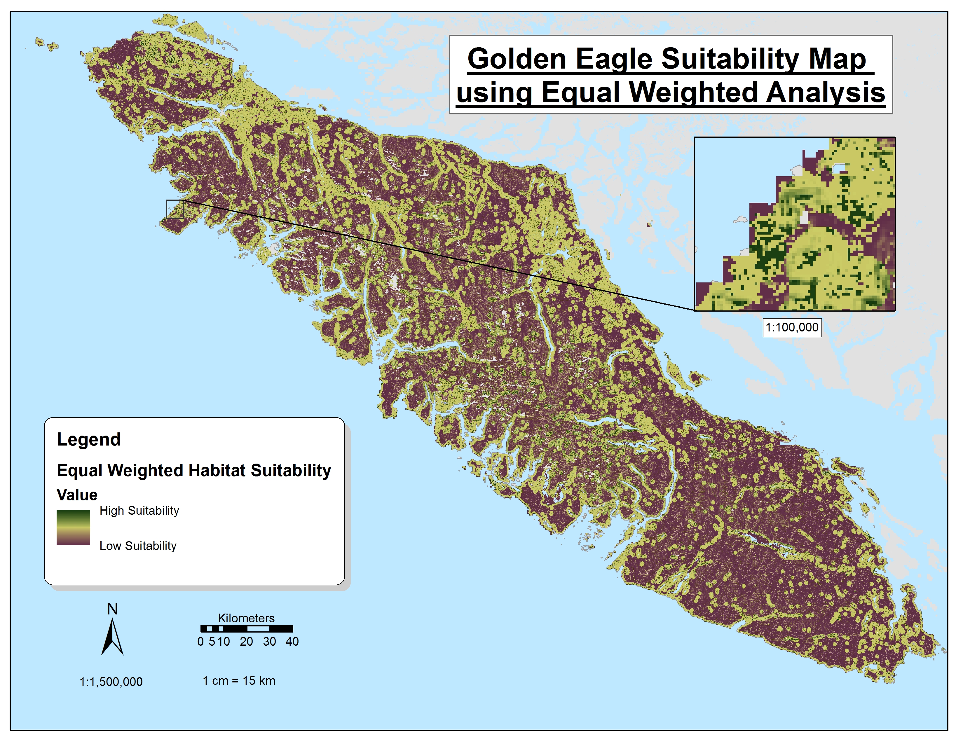 Figure 5: Equal weighted Eagle suitability map:
Golden Eagle’s suitability consists of preference of higher elevation, south-facing aspects, slopes above 45 degrees, exposed/barren land, and distance from water. As such, much of the Golden Eagles suitable areas are at high, barren, and south facing slopes scattered within the mountainous interior. The Eagle is different from its land predator counterparts whereby human influence is not directly unsuitable and so human influenced areas are not as avoided as the land predator.
Weighted Analyzes
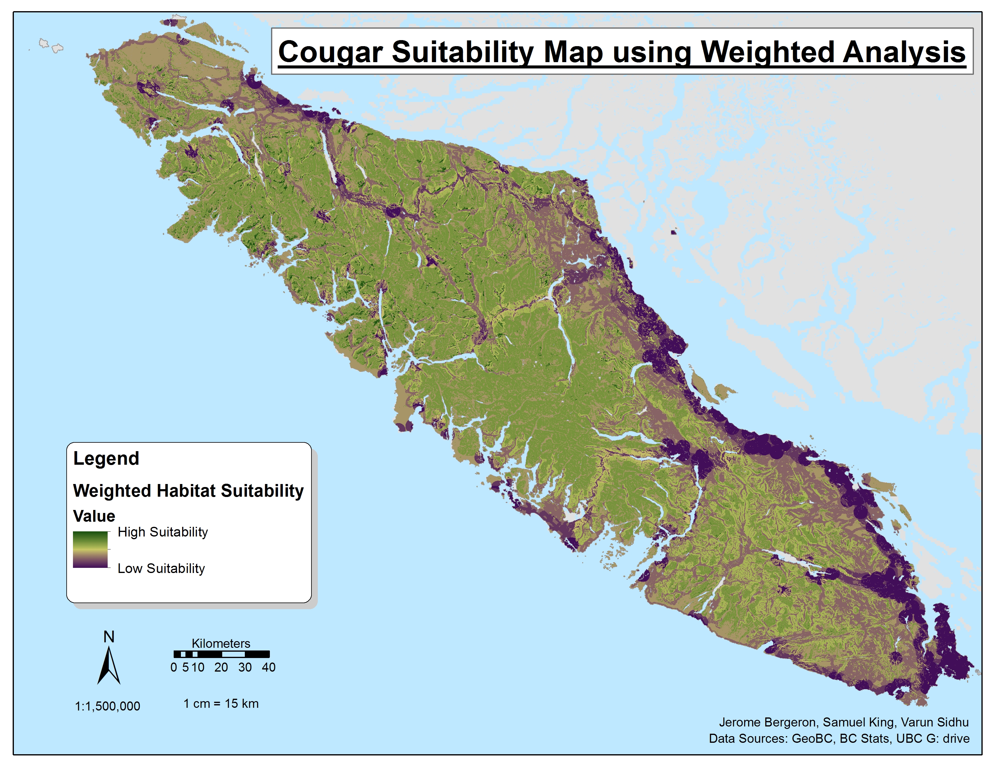 Figure 6: Weighted Cougar suitability map:
Research on cougar preferences dictated a strong suitability for broad leaf forests with slope being a less dominant factor. As such the cougars weighted suitability map differs from equal weighted as the mountainous interior is less suitable in lieu of the broad leaf forest largely along the north-western coast. As usual, heavily human influenced areas are far less suitable for the land predators which remains to prominent factor in cougar habitat preference as dictated by the research cited.
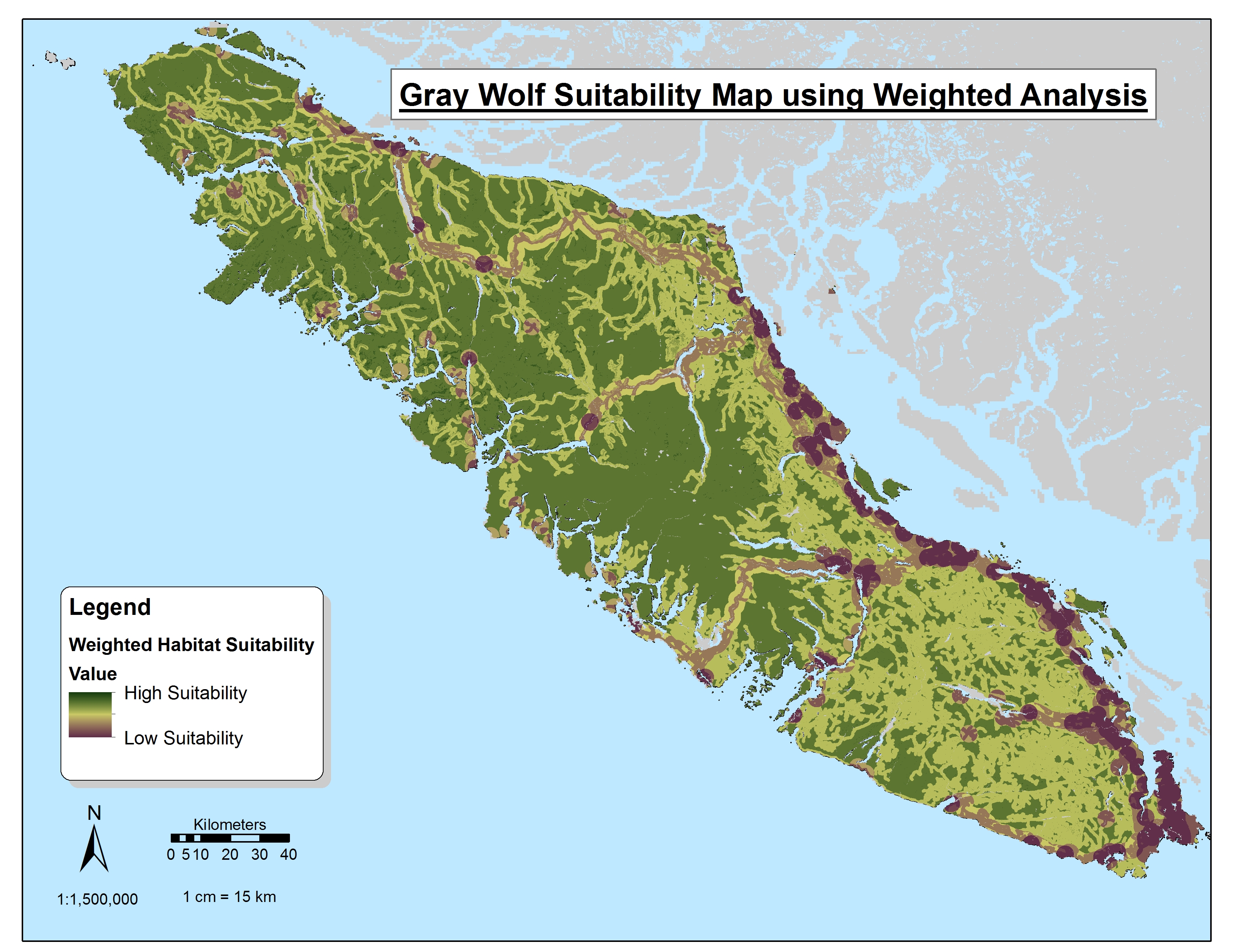 Figure 7: Weighted Wolf suitability map:
Whereas Cougars were most suitable in mixed and broad leaf forest regions, Wolfs were most suitable in regions uninfluenced by humans. As such, the dominant trend is caused by the extreme range in suitability that occurs between human influenced areas (low suitability) and the uninfluenced interior/west coast of Vancouver Island.
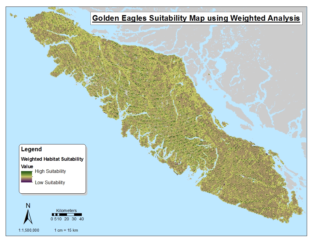 Figure 8: Weighted Eagle suitability map:
Due to 90% of of the Golden Eagle’s weighted suitability being allocated to elevation, south-facing aspect, and slopes above 45 degrees, the strongest suitabilities are focused on all high, southern facing aspect slopes. As well, due to the Eagle’s neglect of human influence, its high suitability range is scattered throughout the island unlike that of the land predators.
Sensitivity Analyzes
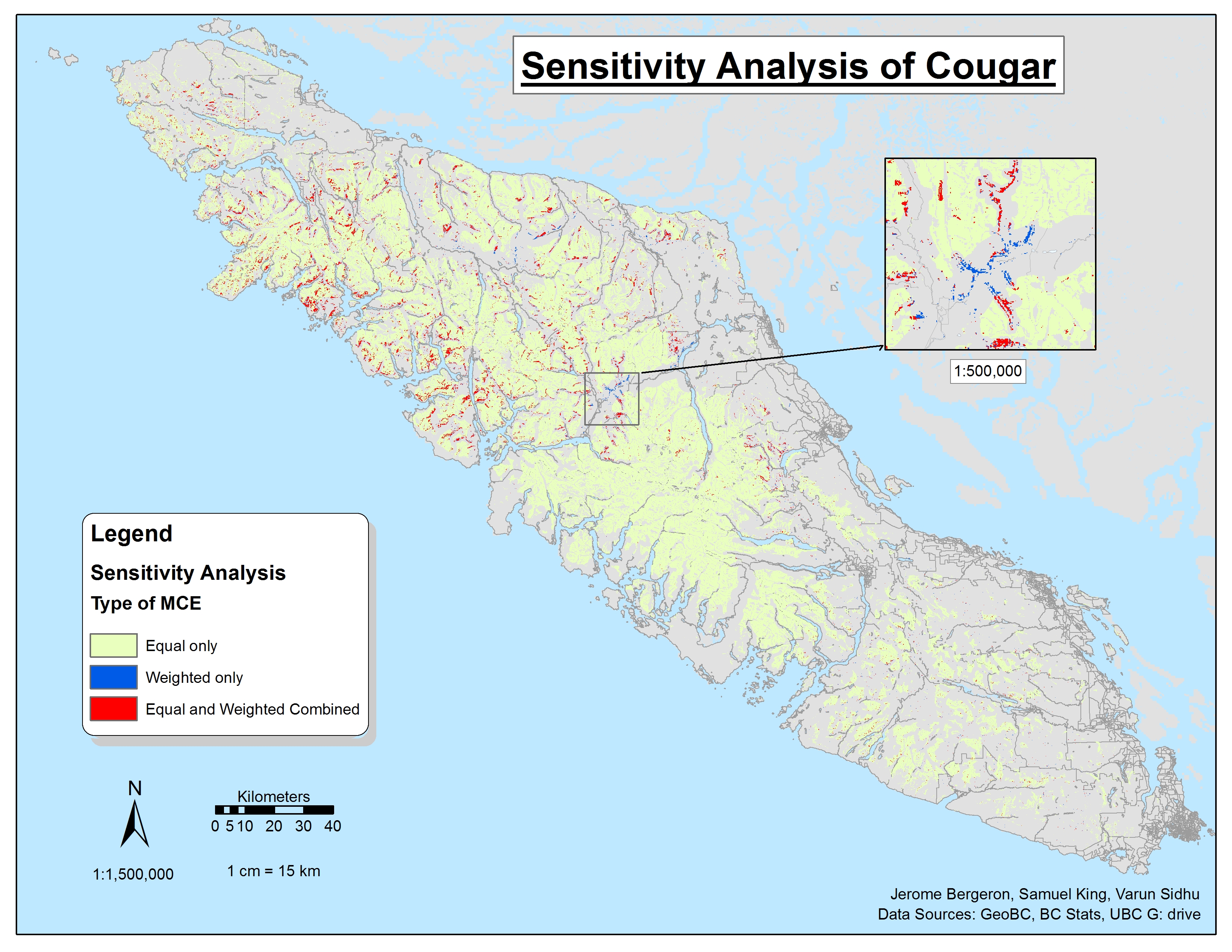 Figure 9: Cougar sensitivity analysis map:
Due to the equal weighted layers stronger representation of non human influenced areas, the equal MCE covers almost all non-human areas which covers most of the interior and west coast of the island. Most of the overlap between the two MCEs is with the forested landscapes which were both prominent deciders in suitability in both ranges.
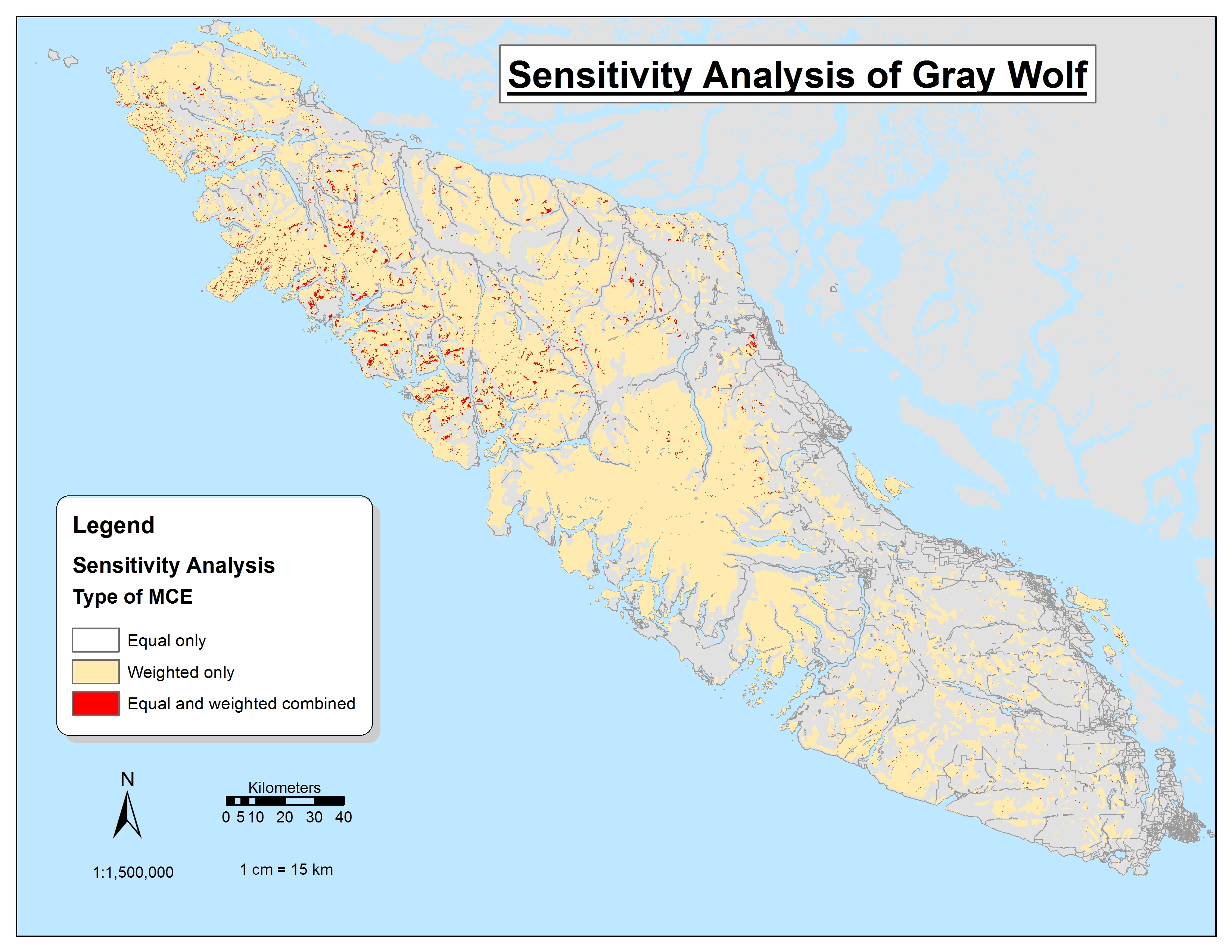 Figure 10: Wolf sensitivity analysis map:
In the Wolf sensitivity analysis, all of the equal weight MCE is overlapped by the weighted MCE due to its heavier weighting of the rarer mixed and broad forests whereas the weighted MCE puts emphasis on the larger distribution of non-human influence features. As such, the regions of overlap between the two layer is seen in regions of mixed and broad leaf forests. Both MCE do however share a trend in which the majority of their points are in the west and interior of the island away from the populated east coast.
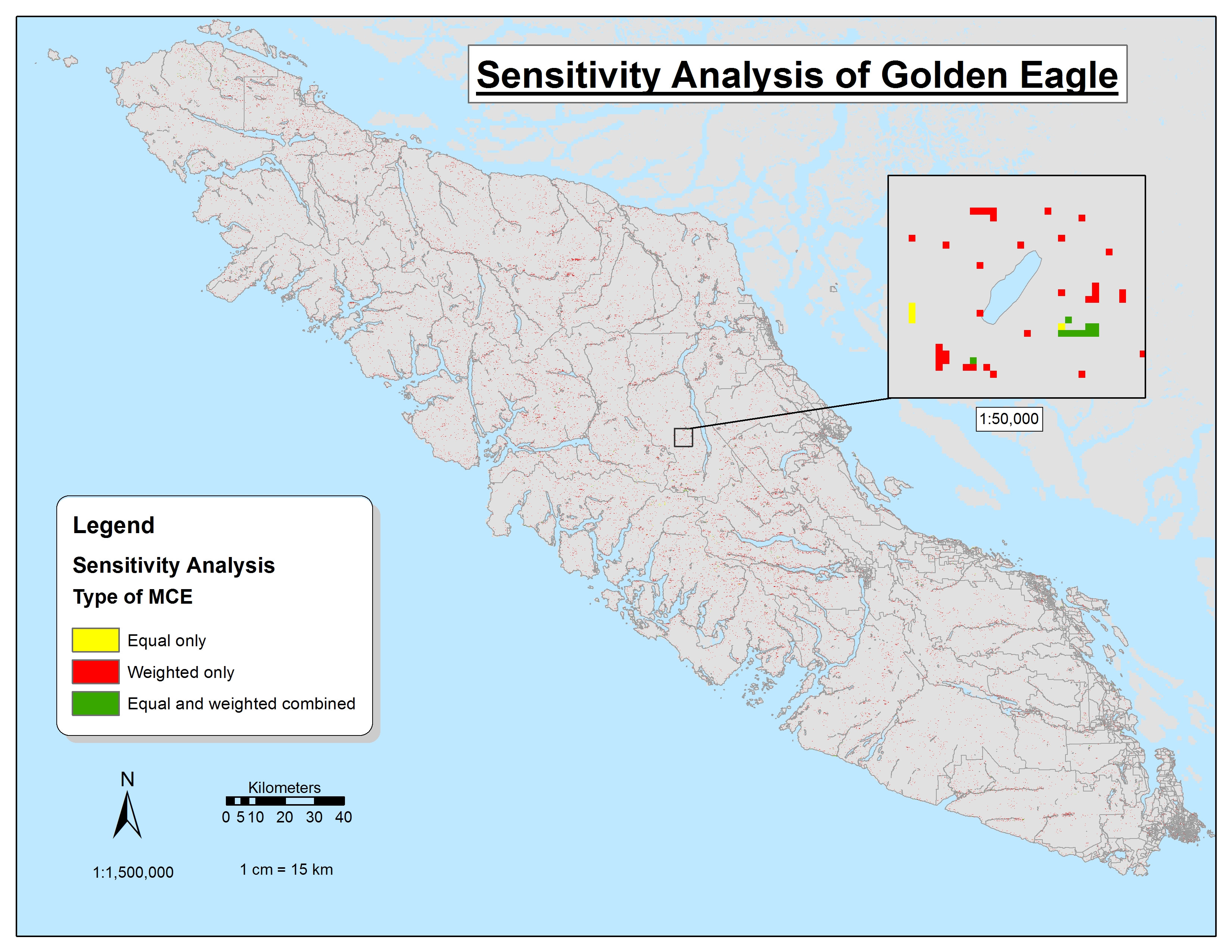 Figure 11: Eagle sensitivity analysis map:
Because aspect, slope, and exposed rock were the most suitable features in the weighted MCE, we see a uniquely uniform scattering of “weighted only” classes which are almost all exclusively located on south-facing, exposed mountainous summits. “Equal only” points are much rarer as they weight higher for distance to water which reduces the maximum suitability of exposed mountain tops seen in “weighted only”.
Final Predator Overlay
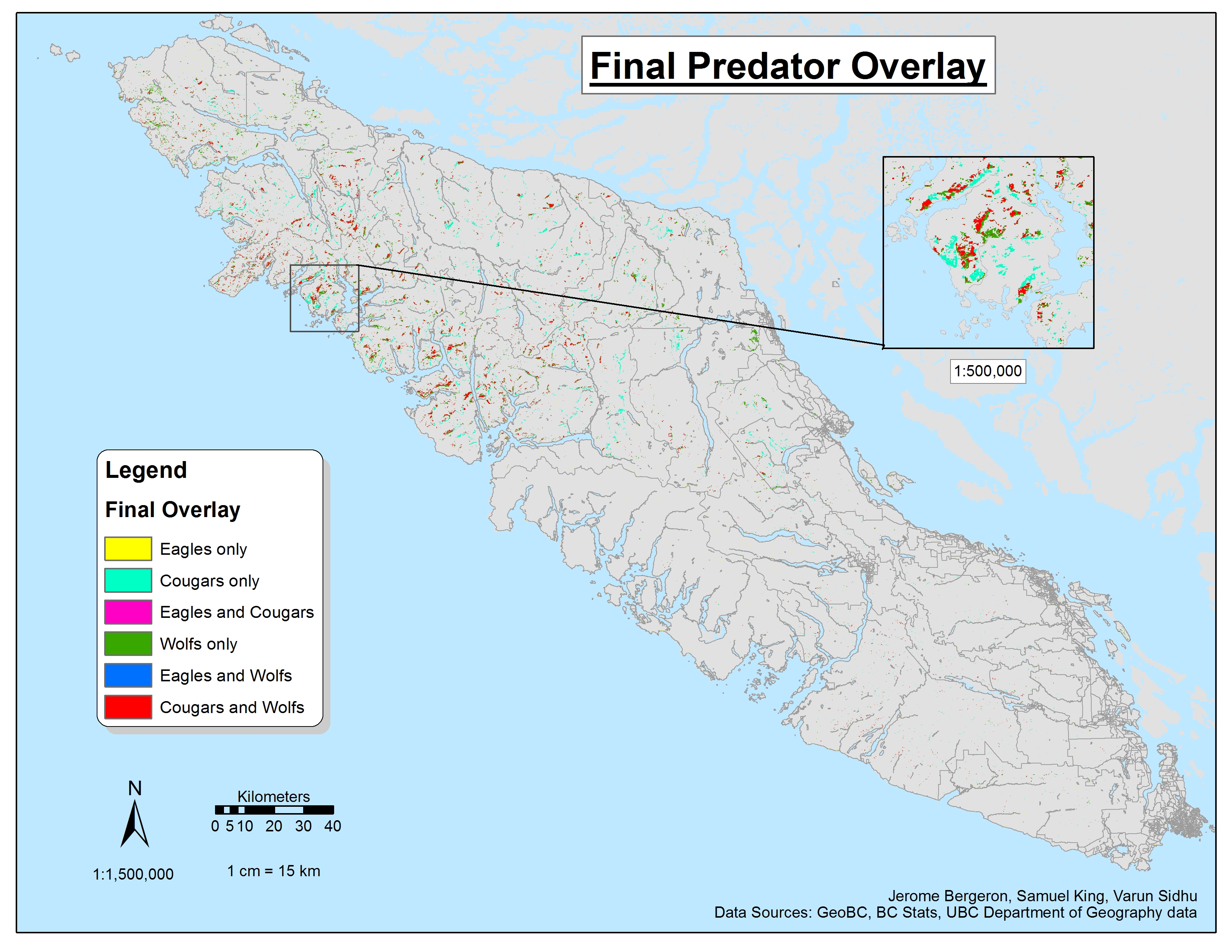
The final predator overlay conveys the reoccurring trend of high suitability in the North-Western interior of Vancouver Island. Most of this NW suitability is for our two land predators, Grey Wolf and Cougar (seen as red), and is largely fixed on areas of mixed and broad leaf forests as these layers were both prominent weights for the land predators. The differences between land predator suitability are seen where slopes emerge. While wolf suitability is unaffected by slopes, cougars are drawn to slopes so we see “Cougar only” regions (seen in neon blue) more prevalent in mountain regions. This trend is especially noticeable when opening the final predator overlay map in Google Earth (download link below). Golden Eagles receive a distinctively lower total area of suitability which may be seen as accurately representing their known real lesser presence on the island out of the three predators. What little regions they do occupy seem to be based in the highest regions of mountains in southern aspects which coincides with their weights. There is no area presented by these results where all three predators habitat overlap.
All in all, the predator overlay maps has functioned correctly given us a distribution which was to be expected although the distinct lack of wide-spread coverage across Vancouver Island for the predators highlight possible short comings in our data processing. Perhaps in the future, higher thresholds of suitability should be chosen in order to increase the presence and range of all predators on the island. However, the analysis completes its untended purpose of suggesting the most suitable regions to predators while subsequently removing the lowest suitability regions from the final overlay.
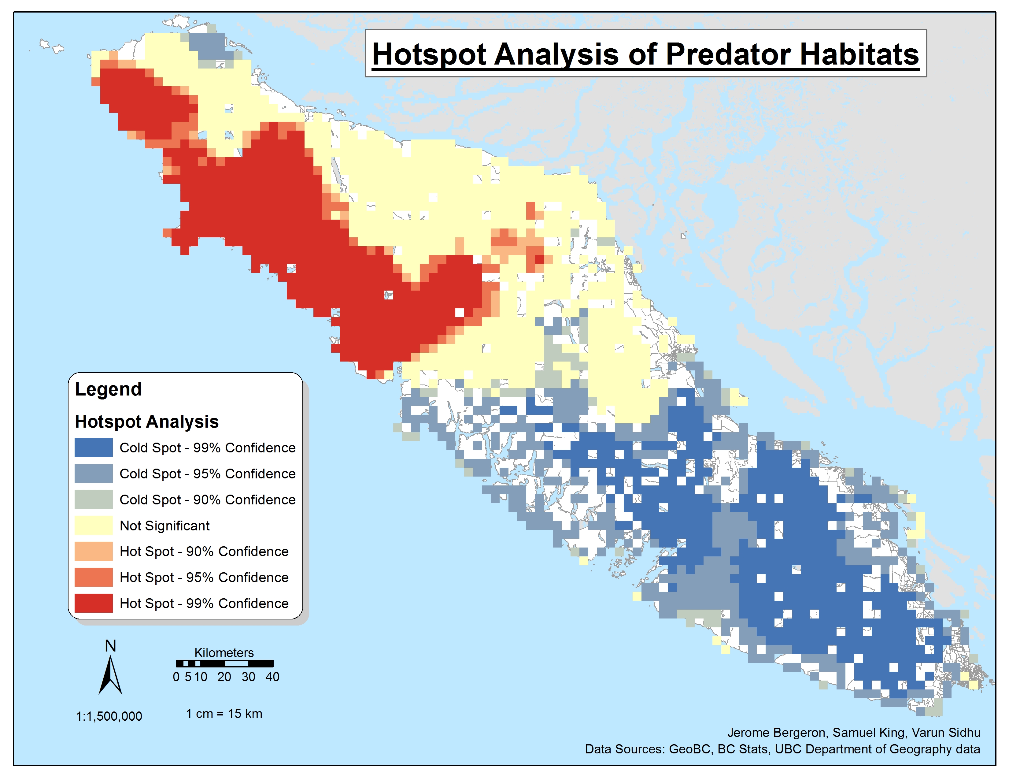
To emphasize the regional trends discussed in the final predator overlap analysis, we have included the above hot spot (or Getis-Ord Gi*). While this map helps to simply and distinguish larger regions as high predator density (red) and low predator density (blue), it should not be directly used in deciding where to reintroduce Marmots. Due to our base results being much finer than the hot spot map’s pixel size, the map suffers from heavily from the ‘Mixed Areal Unit Problem’ and must only be used as a general reference on which sections of the island see more of the 3 predators.
To conclude, these analyses of predator suitabilities were conducted as a resource for researchers to decide what regions exhibit high risks for predation on the Vancouver Island Marmot. Previous work on modelling suitable regions for the species had been conducted yet, their limitations typically cited lack of predator modelling which we aimed to rectify with this research. Our analysis alone is not enough to state where Marmots should be reintroduced into the wild but, can be used in conjunction with Marmot specific MCEs. For further reading on modelling a Marmot specific MCE can be found here written by fellow University of British Columbia graduates, Caitriona Feeney and Lauren Taylor.
View interactive Final Overlay map: Click here for results through Google Maps
View interactive Hotspot map: Click here for results through Google Maps
Limitations:
A very visible issue with our Golden Eagle maps is its far smaller suitability range than expected. Some have commented these maps that, while the chosen variables and their weights are appropriate, their range should intuitively be larger than the land predators as the Eagles can fly great distances to catch prey. While the point is accurate, the short coming is not specifically with the Eagles range but with all the predators. Each predator can travel large distances in a single day in order hunt its prey which means that all the points given on our final predator overlay map are somewhat disingenuous as they do not represent how far a predator typically travels outside its preferred habitats to catch prey. As such, our final overlay should be considered a distribution of predator “home conditions” were they are expected to base their populations around though not necessarily stay exclusively in. In order to account for this, we have included a ‘predator heat map’ beneath our final predator overlay map in order to highlight increase in risk for the reintroducing of Vancouver Island Marmots as we increase in proximity to these predator home locations even if they aren’t necessarily within these regions. However in the future, we would seek to put buffers on our final predator areas based on predator-specific research indicating how far on average each predator will travel in its hunt for prey.
Another large imitation was the lack of obtainable prey data for our wolf analysis. The research found for wolf habitat constraints and suitabilities frequently placed heavy emphasis on the occurrence of preferred prey being the most important factor for wolf populations existing in certain areas. As such, our initial wolf analysis was planned to put prey prevalence and density as the highest weighted factor. These prey were White-Tailed Deer and Roosevelt Elk. While both prey had presence on Vancouver Island, their geo-referenced data proved very difficult to obtain. Going through several databases, our most fruitful outcome only provided a table with Elk counts per BC municipalities. This was not only unprocessed data for only one prey but, used too large of ‘spatial bins’ for any appropriate analysis to be considered accurate. All other possible datasets were behind paywalls which even with university permissions and aid, we could not obtain. This shortcoming most likely effects the results of our wolf analysis most and would be something we would seek to change given the chance to redo this project.