Geospatial Analysis of the Alberni-Clayoquot Agricultural Land Reserve
Our analysis of the Agricultural Land Reserves (ALR) in the Alberni-Clayoquot Census District can be found at the following link: GEOB270-Alberni-Clayoquot-Final-Report
This project was performed to look critically at the current situation of British Columbia’s ALRs. As the name implies, ALRs are land that has been set aside mainly to be used for agricultural purposes by the provincial government. As a class we worked in groups to assess the ALRs of individual census districts to examine how the land is actually being used in these areas and also the suitability of this land for agricultural purposes. We worked in a team of four students and assigned the members of our group different main responsibilities based on our personal strengths and then assisted each other with the other aspects of the analysis and the report end product. Because of this I believe each member of our team contributed in a significant way and we were an effective team. Personally I led the technical aspects of the GIS analysis using ArcGIS and was assisted by my group members on tricky aspects of the analysis. Lucas Worsdell was our lead cartographer and created our initial draft maps that we then improved on, while Nicole Lacis took the lead on organising our team and along with Derek Wiens led the generation of our final report.
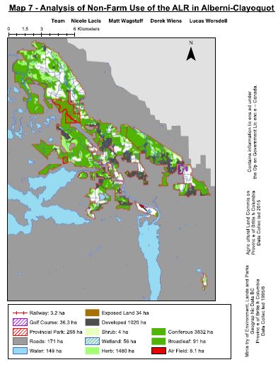
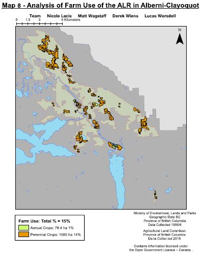
While we didn’t learn many new GIS analysis techniques working on this project, this was a tremendously valuable learning exercise as it required us to bring all of our new GIS skills together and apply them to conduct this complex analysis. Our results were very interesting as I was surprised at the small amount of our ALR that was actually classified in our land cover data as being used for agricultural purposes. By the time we had removed other non-farmable land (such as rivers and roads etc), we were only left with 15% of the area that is currently classified as ALR. Based on this, we believe the area of land stated as ALR in BC is generally exaggerated. We also identified issues with publicly available data as a lot of it is out of date. For example one of our data sets included the location of the Port Alberni Airport, however when we later checked satellite imagery it was clear this airport has been removed and a new one constructed in a different location.
Our team worked very well together and I believe this was a result of effective communication. When working in a team such as this on the same data it is essential that the data stays organised and everyone knows how problems are being approached. These aspects of team organisation, clear role definitions within the team and effective communication I will apply in future group project settings.