
2.1.2 – Students will investigate the physical geography of an Inuit, an Acadian, and a prairie community in Canada by exploring and reflecting the following questions for inquiry:
- Where are the Inuit, Acadian and prairie communities located in Canada?
- How are the geographic regions different from where we live?
- What are the major geographical regions, landforms and bodies of water in each community?
- What are the main differences in climate among these communities?
- What geographic factors determined the establishment of each community (e.g., soil, water and climate)?
- How does the physical geography of each community shape its identity?
- What is daily life like for children in Inuit, Acadian and prairie communities (e.g., recreation, school)?
- How does the vastness of Canada affect how we connect to other Canadian communities?
Program of Study – LearnAlberta.ca . (2018). Learnalberta.ca. from http://www.learnalberta.ca/ProgramOfStudy.aspx?lang=en&ProgramId=564423#235575
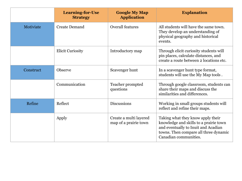
The above Alberta Education Outcome almost seemed overwhelming when I first taught grade 2. I found this week’s reading on Edelson’s Learning-for-use technology design framework had a direct connection with my Inquiry-based unit for Canada’s Dynamic Communities. This is the first time I have seen the My World GIS program; perhaps it is due to that the program is intended for middle school through college geosciences audiences and geography courses. As an elementary, I found the program not a viable option for my elementary students. In saying that, I have used a similar application, Google My Maps, that paralleled My World GIS program design and implementation features that made it more workable for this age group. Edelson, D.C. (2001) illustrates “Learning-for-use is a framework to support the design of learning that integrate content and process learning” (p. 381). Sadly, when I first taught this unit, I used the textbook (yes, there was textbook for grade 2!) and we systemically went through each unit and answered the questions at the end of each unit. It was all direct instruction and not opportunities to using a GIS tool that can “effectively develop students’ spatial awareness while they” (Perkins, N.et al. 2010 p. 218) examine how living things depend on one another for survival.
Edelson, D.C. (2001) noted technology supports inquiry-based learning and learning-for-use. Inquiry-based learning is an approach to teaching and learning that places students’ questions, ideas and observations at the centre of the learning experience. Educators play an active role throughout the process by establishing a culture where ideas are respectfully challenged, tested, redefined and viewed as improbable, moving children from a position of wondering to a position of enacted understanding and further questioning (Scardamalia, 2002). In other words, by using Google My Maps, students can explore the similarities and differences of the geographic areas and explore and search for data and understand how the vastness of Canada affect how we connect to other Canadia communities.
 Edelson, D.C. (2001). Learning-for-use: A framework for the design of technology-supported inquiry activities. Journal of Research in Science Teaching,38(3), 355-385.
Perkins, N., Hazelton, E., Erickson, J., & Allan, W. (2010). Place-based education and geographic information systems: Enhancing the spatial awareness of middle school students in Maine. Journal of Geography, 109(5), 213-218.
Scardamalia, M. (2002). Collective cognitive responsibility for the advancement of knowledge. In B. Smith (Ed.), Liberal education in a knowledge society (pp. 67–98). Chicago, IL: Open Court.