We might notice Vancouver has a nickname “Raincouver.” When heavy rain hit Vancouver, is there chances of Flooding? In this lab, we will look at some of the potenial area vulnerable to flooding risk in Vancouver. Another risk is storm surge that is normal in the condition of low pressure squeezing underneath of high pressure and receiving high wind speed. In this case, hurricane feeds on the warm water in the ocean, and the high wind speed circulating around the eye causes sea level rises when it makes a landfall.
In the case of storm surge, we can conduct a stimulation of a storm surge that would have immedaite effect on determined by 1 kiliometre inland from the shoreline and up to 6 meter above sea level.
In my process, the steps are followed:
- Reclassifying areas using a digital elevation map by categorizing elevation that are below 6m has potenial flooding.
- Using the buffer tool on areas of 1 kilometer within and outside of shoreline of Vancouver
- The process of raster to polygon tool and intersect tool to combine step 1 & step 2 into one polygon layer
- Select features that intersect with potenial flooding areas by using query.
- Editor tool to clip Vancouver hospital area, and potenial areas around hospital that are at risk of flooding.
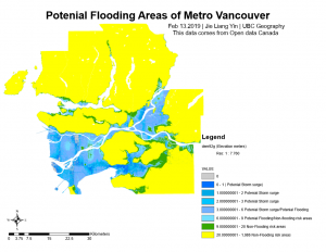
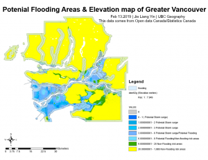
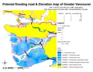
Our first step is to add all data relevant to Vancouver’s base map, and their DEM. Reclassifying and buffering is our main methodology to conduct analysis. We only interested that intersect satisying the two condition that are within one kilometer of shoreline and below 6m in elevations.There are 749358 pixels that have values of 6 meters or less in Metro Vancouver. We will mutiple pixel size area by pixel value to obtain area in km square. The total area effected is 468348.75 km square. We added the streets that are effected in the case of an flooding event (Figure 2). We determined that 372896.43 km square is effected. Lastly, Vancouver’s St. Paul’s Hospital has been designated to move to the west side of the False Creek Tidal Flats in Vancouver. We have to add Vancouver St’s paul hospital into our map, and select by attribute of all schools that fall in the danger zone in those area.
Figure 1) Four maps of Vancouver that correspond to their title and further analysis