In this week’s lab work, our focus is conducting an environmental analysis on the Garibaldi Squamish Project which includes up to 124 ski trails and 21 lifts; it will be an all year-round mountain resort located on Brohm Ridge, 15km north of Squamish on Highway 99. The highlight of this project will open up to 900 construction jobs during planning process, and 2500 jobs to implement the operations. The project has initally proposed since 1997 with a range of discussion, but our role is to act as the BC Environmental Asssesment Analyst to critize and evaluate the project’s potenial effect on vegetation, wild species, river habitat, and potenial consequences from climate change.
As a natural resource planner, my role is to evaluate and assess issues that revolve round the development of Squamish Ski Resort. Throughout my process, I have determine the areas of potenial low snowfall, and plan for mountain resort locations. The highlighting issues revolve around the influence on natural habitat in those areas, and potential risks that needs to be dealt with.
I have created two individual maps to lay out the protected old growth forests, ungulate habitat areas, and protected riparian areas. Another map to visualize the hillshade of the protected areas on habitat mentioned above.
Figure 1. Environmental Impact of Squamish Ski Resort by applying buffer on River habitat and selecting Ungulate habitat areas, Old growth protected areas.
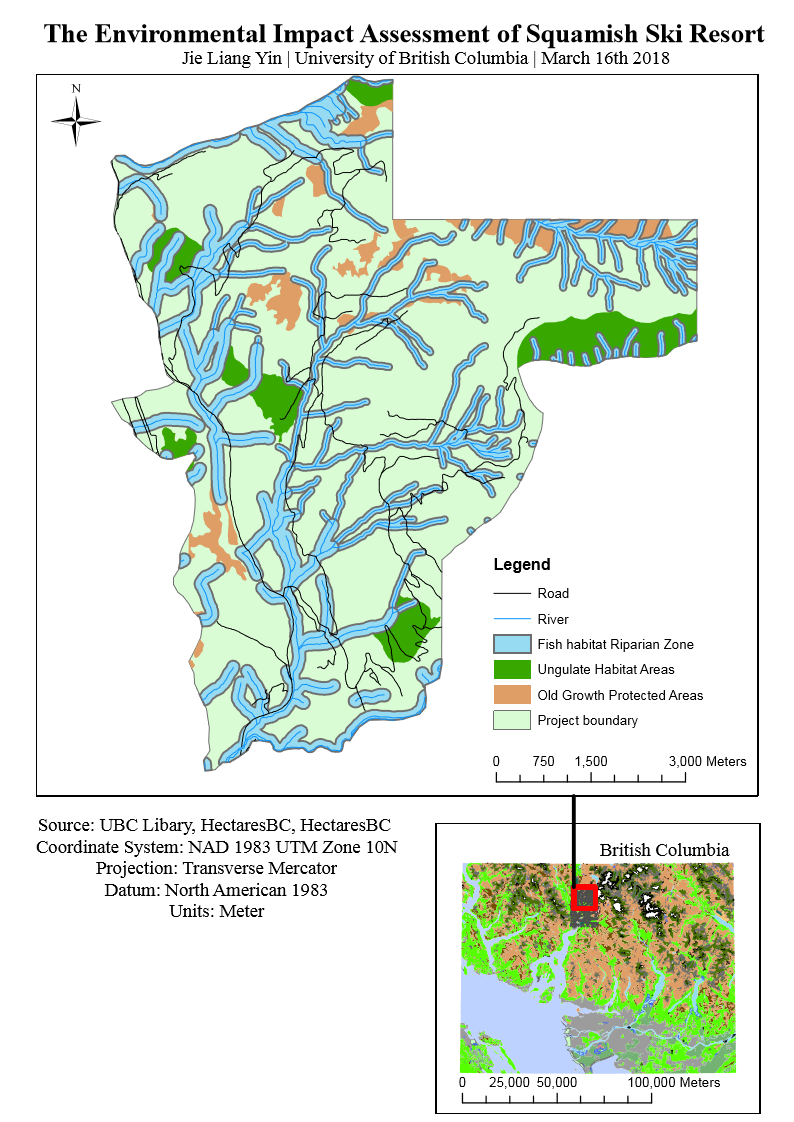
Figure 2. The hillshade effect of applying topography on study area
First of all, I parsed all of my data from UBC library, BC Data and filtered them. I found that 31.8% of our total area falls under 600m elevation. The result is that it could potentially lead to no snow falls at those area, and therefore the ski hills could be constructed in the remaining 58.2% of our total area. Another case is that 31.8% of the land may result in poor skiing conditions and would not be a great attraction in one’s perspective. In respect to climate change, the mark for elevation could potentially increase because the global temperature is rising. In cases, where if it fails to receive the ideal amount of snow each year then it could mean an even smaller area of skill hills due to areas with snow cover is smaller than project areas. After filtering the data, I was able to propose the fact that the 31.8% could be used for other purposes instead of ski hills. The ski resort is optimum alternative solution that could be built at the base of the ski resort, and by using the low elevation marker as an indicator to know how big the building area is going to be. There could be extension for tourist attractions, hotels, and recreational activities.
Afterward, we used Arc tools to clip the layers onto our project boundary to find out the area of protected Old Growth Forest cover and Ungulate habitats, which include Mule Deer and Mountain Goats. The results is 7.89% for ungulate habitat and 6.78% for old growth forest. The ungulate habitat covers 7.89% of the total project area, and they cover only a small portion of the total area in addition to overlaps with other protected areas. The high possibility is that these habitat are restricted from the resort, and therefore in decrease the amount of land use that overlaps with building construction. We can see that some of the areas are located in the 600m lower elevation so resort needs to be established carefully so it does not destroy the natural habitat in those areas. The 6.78% of old growth forest also shows more overlaps with protected streams because they are more distributed than ungulate habitat areas.
Our next stage, we used buffer tools on our rivers to cover up the fish habitat areas that are especially vulnerable. We used 100m width buffering on elevation lower than 600m and 50m for elevation higher than 600m. Our result showed that 31.04% of our total land area is covered by fish habitat. This step had to be carefully analyzed so that the river stream system does not get damaged. The river stream flow from top of the mountain to below therefore pollutants can easily dissolve and endanger the species in those areas. The buffering of 100m on elevations lower than 600m showed a higher total area than elevation higher than 600m. One of the reason is because the buffering distance is not the same, but because the lower elevation have a larger buffer; it does not affect ski runs as those areas are below the snowfall line. The 50m buffers in the higher elevation would allow a better ski condition. We used overlay, and union tools to combine our protected area to calculate the total percentage of land that is protected. The formula included fish habitat, ungulate habitat, and old growth forest. We found that 40.75% of our total area is labelled as protected area, but when we added the percentage of all protected areas that we calculated from above. Then there is a 4.96% increase from 40.75% and the reason is because the dissolve tool made the overlapping area dissolved, so there is less area in between space of habitat. After all the analysis, we still see more than 50% of the land that is usable for ski resort, and there is an open area in between river streams and other habitat in the middle of the project boundary. Therefore it serves a great environment for skiing condition. One of the challenges would be managing the ski runs according to the network of rivers, since there would be a lot of overlapping between ski runs. Another challenge would be managing the ski resort below 600m because a large portion of land is covered by protected habitat. The ski resort design and construction process would need to work around the way so it does not damage the system. The ski resort would need to work around these restriction, and because river streams are the biggest challenge; also the largest protected area therefore it is important to design the ski resort to account in all these factors. The source of errors in my analysis are the fact of buffering is not the full analysis on river streams, because there are cases of erosions; other scenarios of avalanche, climate change, increased discharge could also cause an impact on river flows. This principles applies for other habitat areas in case of natural disaster, and I considered taking in account of vulnerability increases if there is ski resort.