One of the widely dicussed topic about UBC is student’s concern in regards to sky train stations that is planned to be built from Arbutus station to UBC. This severs a chance for students to be encouraged to focus more on school work, and save more time on the road. In this project, I really wanted to take a look at what are some of the planning criteria that needed to be satisfy when setting up a translink route. With Translink’s proposal to setup a route from Broadway to UBC, and after research UBC-Broadway is the busiest bus corridor in North America. The translink station is usually set to include three types of facility with a function of: Stations (serving high-capacity and rapid transit), Exchanges (serving multiple bus routes, including bus
layover space), and Stops (serving one or more on-street bus routes). When these criteria are met, the usage of skytrain will highlight decrease the burdan of Bus routes. In the beginning of our analysis, I wanted to include the Canadian sky-train to visualize the distance between stations, as well land usage on those areas. That includes extracting data for all specific information we would need, and for an example, the layers of land use will overlay ontop of a base map of Vancouver. Afterward, we can include Census Boundaries, Vancouver streets, Bus routes, Schools, Skytrains. The general idea is that we can package a variety of maps to find the ideal stations and number of stop. The next step is extracting information of population density, age population, and neighborhoods to classify quantitive data. Each step require sentivie caution and we will a variety of tool to make sure data’s can provide sufficient knowledge to us.
In our analysis to designate the proposed transit line from Arbutus Station to UBC Station. We will focus on a few proposed stations that will maximize the benefits in neighborhoods to ensure a better traffic flow. The first step is to determine land usage data across Vancouver area and determine the limitation of our sky train and stations. Therefore, we can clearly differentiate between residential areas versus commercial streets. In map 1, that can been seen in the appendix, we mapped the land use from Arbutus station until UBC, and we see that West Broadway is the center of business sectors. The train will change into West 10th after it has reached Alma Street because then there is a school zone that would collide with our route if it had proposed to set path along West Broadway. We conducted further analysis to check for areas with commercialized land use, because it would be highly populated during peak hours. On the other hand, I notice the number of existing Canada line stations are built based on the commercialized or industrialized land use portion across Vancouver (Map 1). The usage of sky train will lower the burden for buses and slow down the traffic in an efficient manner. We notice a commercialized land use at the Sasamat Road, and we must conduct buffering to analyze the effect of sky train stations at commercialized area with high population density. One of the questions that arise in our proposed transit line is to determine the number of train stations from Arbutus station to UBC. Our goal is to minimize the burden of bus frequency from Arbutus to UBC. Therefore, we will calculate the effecient usage of time for our bus route. The results to the calculation of our route from UBC bus exchange to Arbutus and Westbroadway is 7km using Google Maps. The top speed of Canada line is expected to be 80km/hour therefore if we divide the total distance by speed then we can determine efficient time allocated on transportation. It is followed as:
Total Distance: 7000m, 7KM
Speed of Travel: 80 KM per hour
Total Distance/ Speed of Travel = Time
7/80= 0.0875 of a hour, and convert into minutes 0.0875hour x 60 minute = 5.25 minutes time used for travel
Figure 1. The land Use distribution in Vancouver
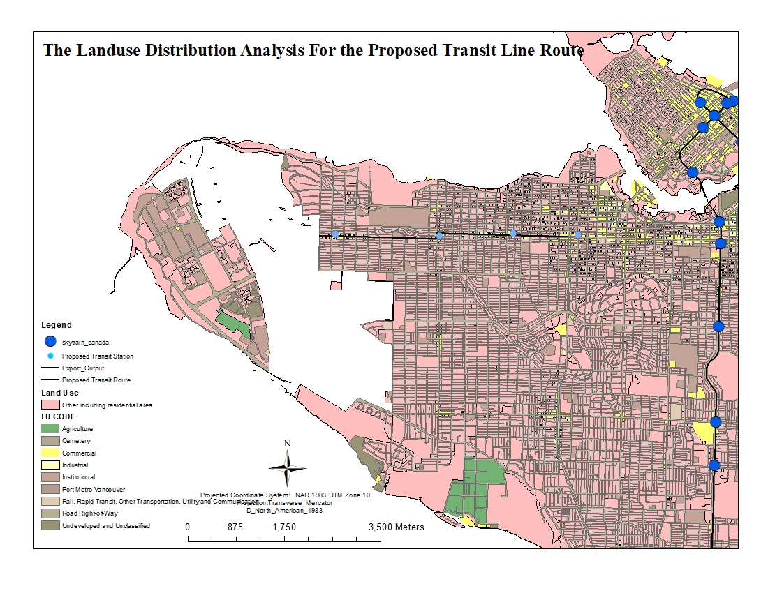
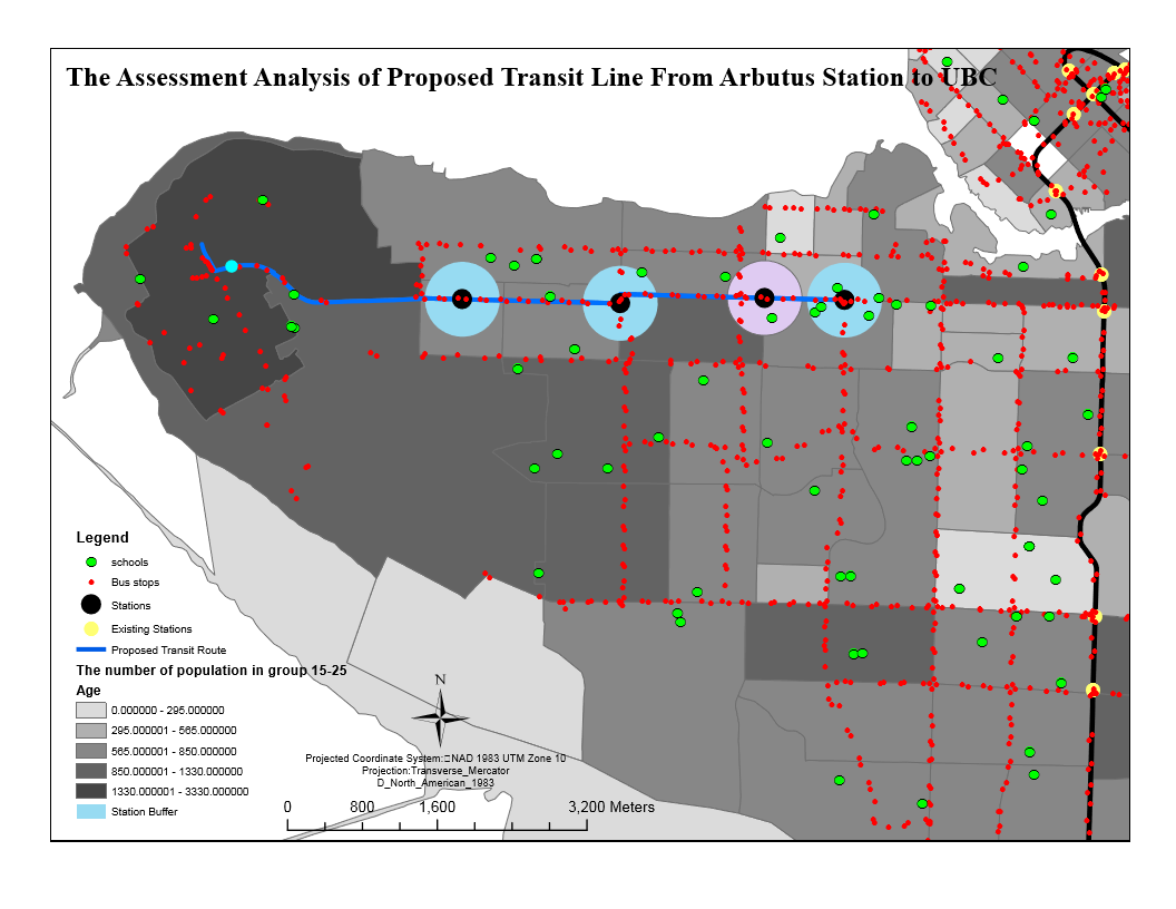
The highlight of this was that most Canada line sky train stations was built on the basis of land use of commeralized area. Part of the reason is that neighborhood area are not suited for operational matter and the noise effects is too large to be neglected. We can see that on the Canada line sky train station, the highlight of yellow land uses are matched with skytrain stations; including yaletown area with mutiple stops. Therefore we built four skytrain station that would extend into university blvd by assigning them to the best position in commercialized area. Each station will be located at Arbutus Street and West Broadway -> McDonald Street and West Broadway -> Alma Street and West 10th Avenue -> Sasamat Street and West 10th Avenue. We decided to use a buffering of 400m because it contains Arterial streets designated as transit corridors should ideally be spaced a maximum of 800 m apart to create a maximum walking distance of 400 m from the interior of each block.The travelling time of 5.25 minute from Arbutus to UBC leave us with a lot of room to set stops with longer duration because West Broadway is highlight packed with population; we can also consider for safety condition. When I looked at how land usage has a high correlation with how sky train station is built, I added quantitive data of population density in those area. I learned to extract data on number of population that uses public transportation to see plan further analysis of station stops. The results is that most sky train in commercialized area fall in the more heavily populated region. (Map 2)
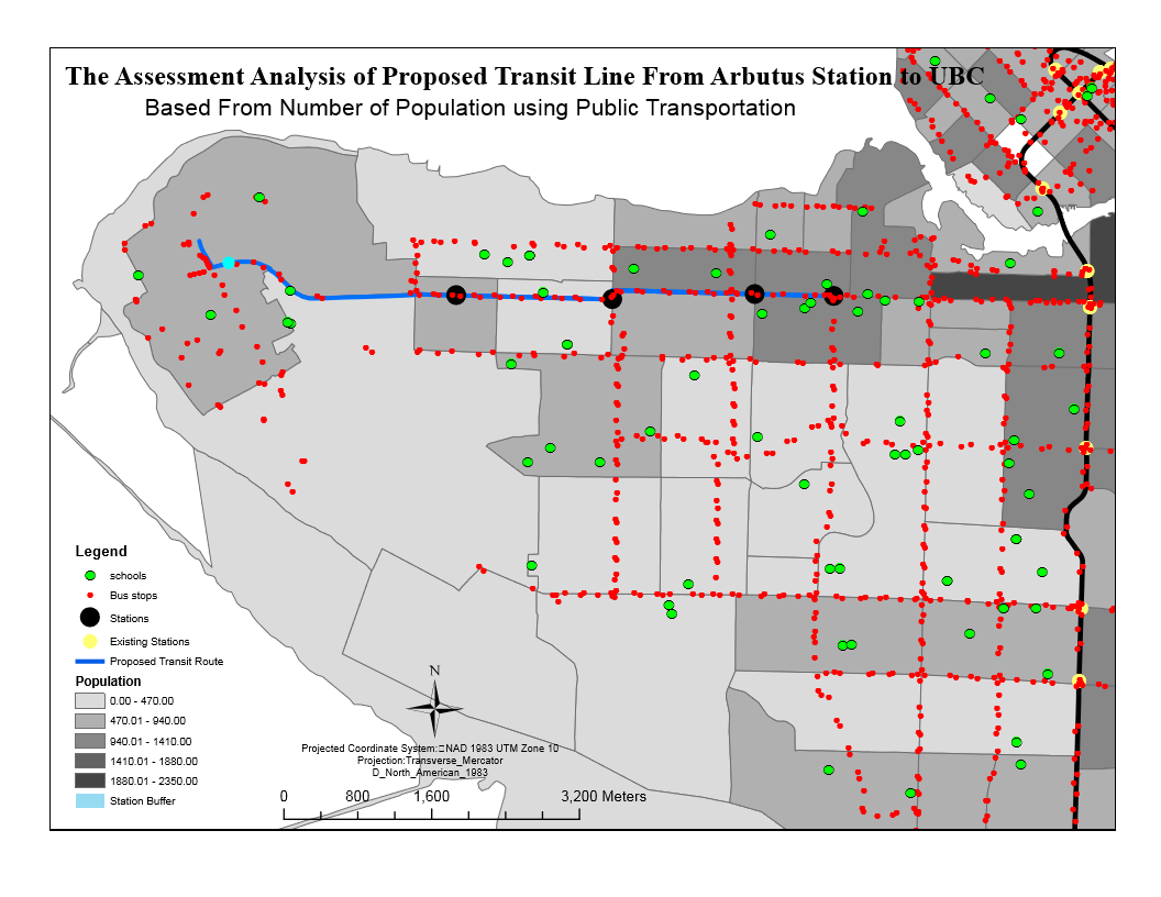
Lastly, I wanted to add combine data’s to verify the population density in Vancouver and how stations would benefit neighborhood areas. I added the all schools in Vancouver area including bus routes to visualize if it can satisfy the second condition of facility type (Exchange to serve heavy populated bus route). The map three demonstrated effective measure on routes that intersect and as well the arbutus station covered five school in the region of buffer. The other station serve as the centre between intersecting bus labelled by red dots. The darker color scale in the background represent higher population in those area, but even still for people that live higher up in the north of Westbroadway still has opportunity to take bus to the main roads. Therefore, the buffer still acts as a useful tool to help us measure the area that is covered.
Throughout the project, I learned a lot about planning process. The basic steps when building an object and their impact. It is very vital we provide accuracy assessment and the surrounding impact of development. I learned that Skytrain stops and city planning are always based on the fact it would be used in highly populated industrial area. I am not saying it is for sure, but an area developes because of skytrain development, housing improvement, or urban sector. I learned that if skytrain is modified, then it can bring a lot of changes to an area, and the space of flow. The first thing was that I built stations on areas with highly populated density and comemrcialized land use places. Afterward I learned these places are area with high bus intersections and busy routines. In conclusion, the city planning for skytrain/subway always has correlation to areas with high attraction of people flow.