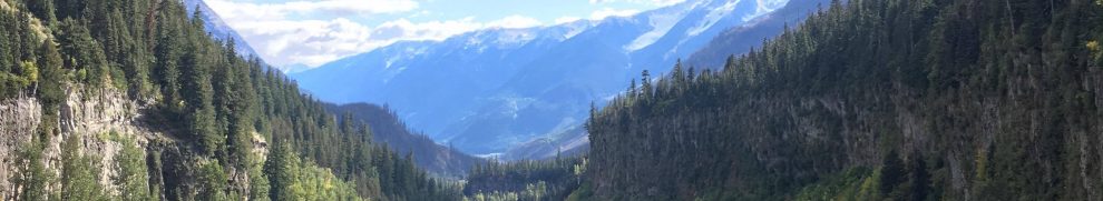
Although mass movements are not directly caused by active volcanism, they are an impressive hazard for years after eruption. Volcanic edifices are formed of weak volcanic rock, and in the case of Mount Meager, they rest on very strong intrusive bedrock creating a strong contrast. The weak volcanic rocks are highly susceptible to alteration and intrusion by water, resulting in an array of mass movements. For example, in 2010 a massive rock slide turned debris flow broke off the southern flank of Mount Meager, and dammed the Lillooet River (Figure 1) which prompted a state of emergency downstream.
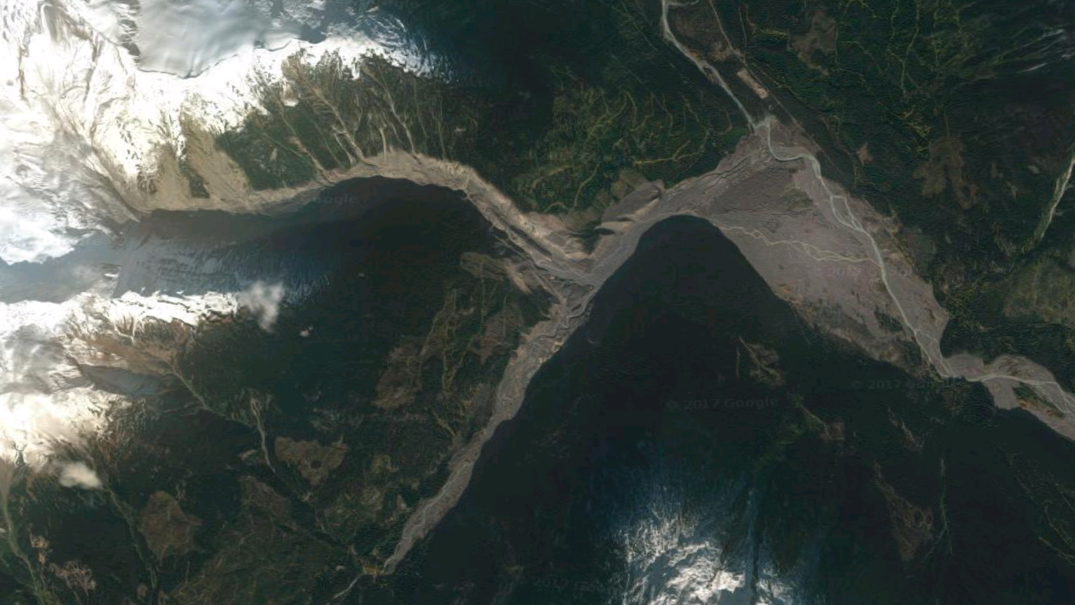
Figure 1: The scars from the 2010 rock slide-debris flow at Mount Meager. The scarp from the initial slide is visible under slight snow cover in the top left. After channelizing some ways down Meager Creek, the flow traveled up the opposing valley wall and up the valley itself before damming the Lillooet River (from Google).
Methodology: Five hypothetical instances of debris flows and rock avalanches were modeled using Laharz_py after completing a simple multi-criteria evaluation (MCE) of the volcanic complex using slope and lithology from a digitized map of Read’s (1977) work on the complex. The methodology when using Laharz_py was the same as the modeled lahars (see Lahar under Methods and Results). Slope was ranked from 1 to 0 using a linear fuzzy membership, with 1 being at the highest slope values and 0 at the lowest. Lithological ranking was slightly more complex. A generalization of their ranking is shown below in Table 1. Once ranking was complete, the lithological map was converted to raster using the MCE rank field as its value. The two ranked rasters were then overlayed using equal weights (Figure 1). General areas which appeared the most susceptible were then manually delineated and selected as source areas to model both debris flows and rock avalanches (Figures 2 and 3).
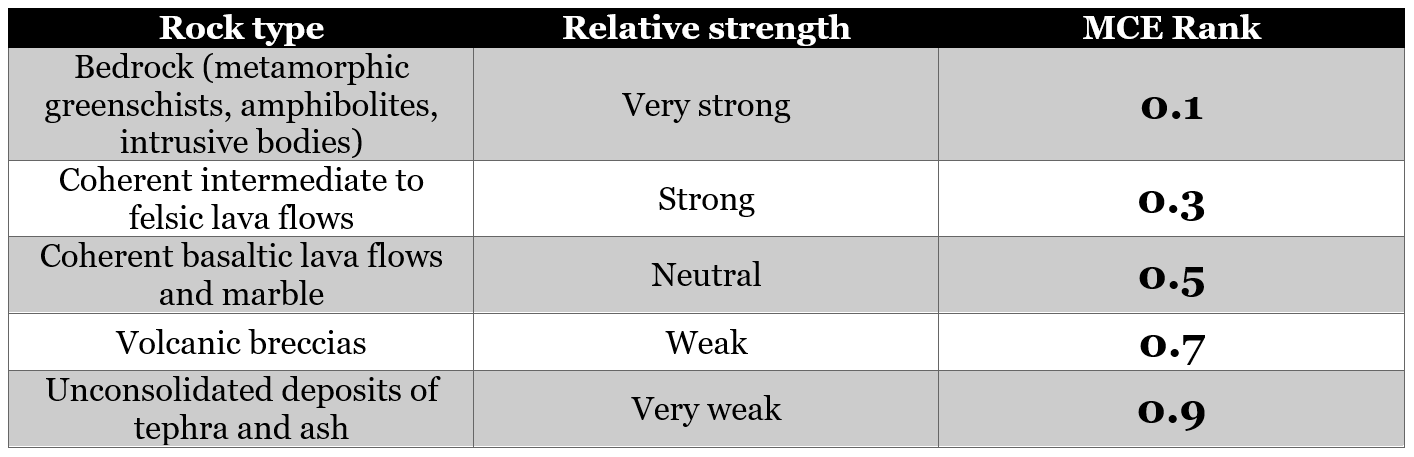
Table 1: Lithological ranking for use in multi criteria evaluation of the Mount Meager Volcanic Complex. In general, individual ranks were based on coherence of each rock or deposit type.
Results:
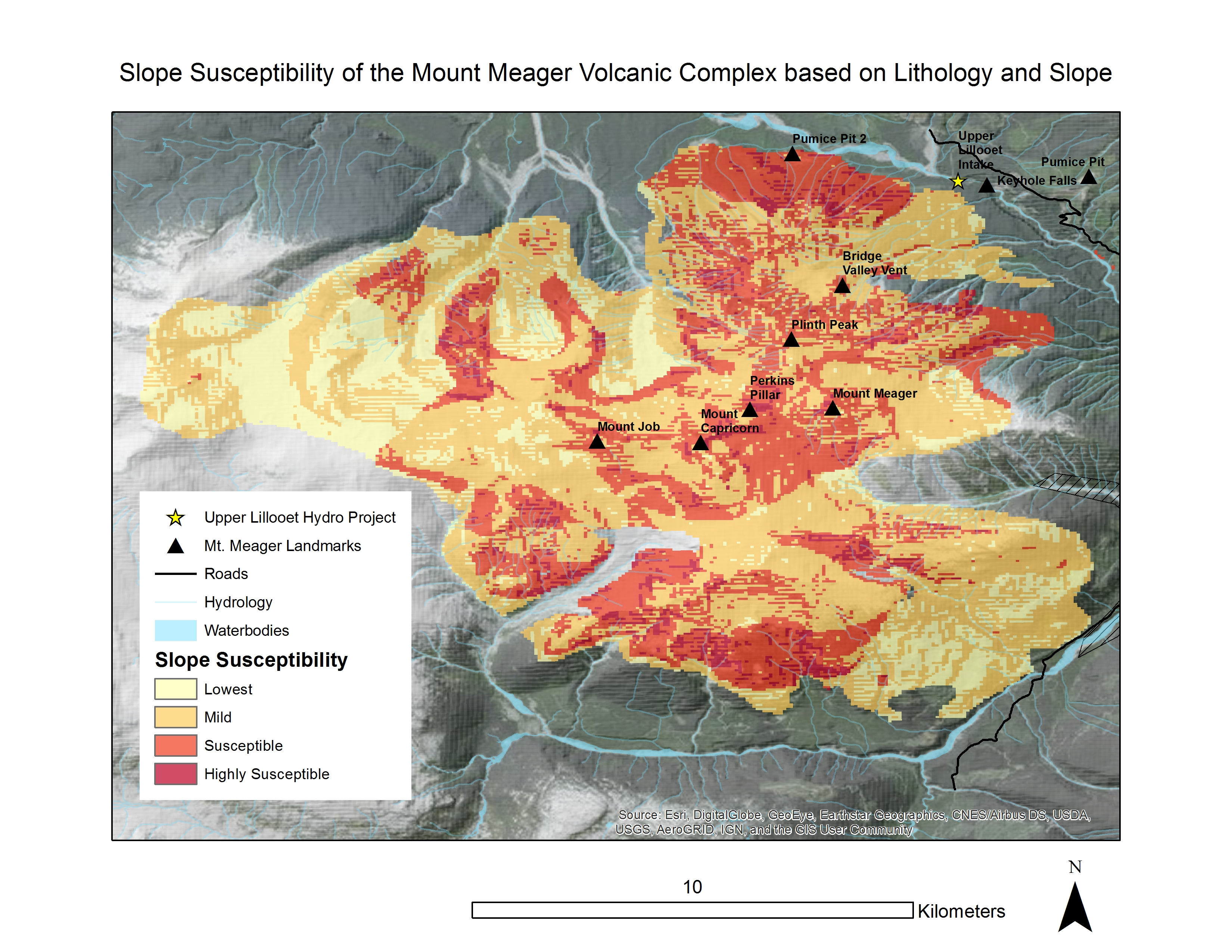
Figure 1: Slope susceptibility of the Mount Meager Complex based on lithology and slope. Breaks in categorization of susceptibility are equal breaks, representing 25% of the dataset each.
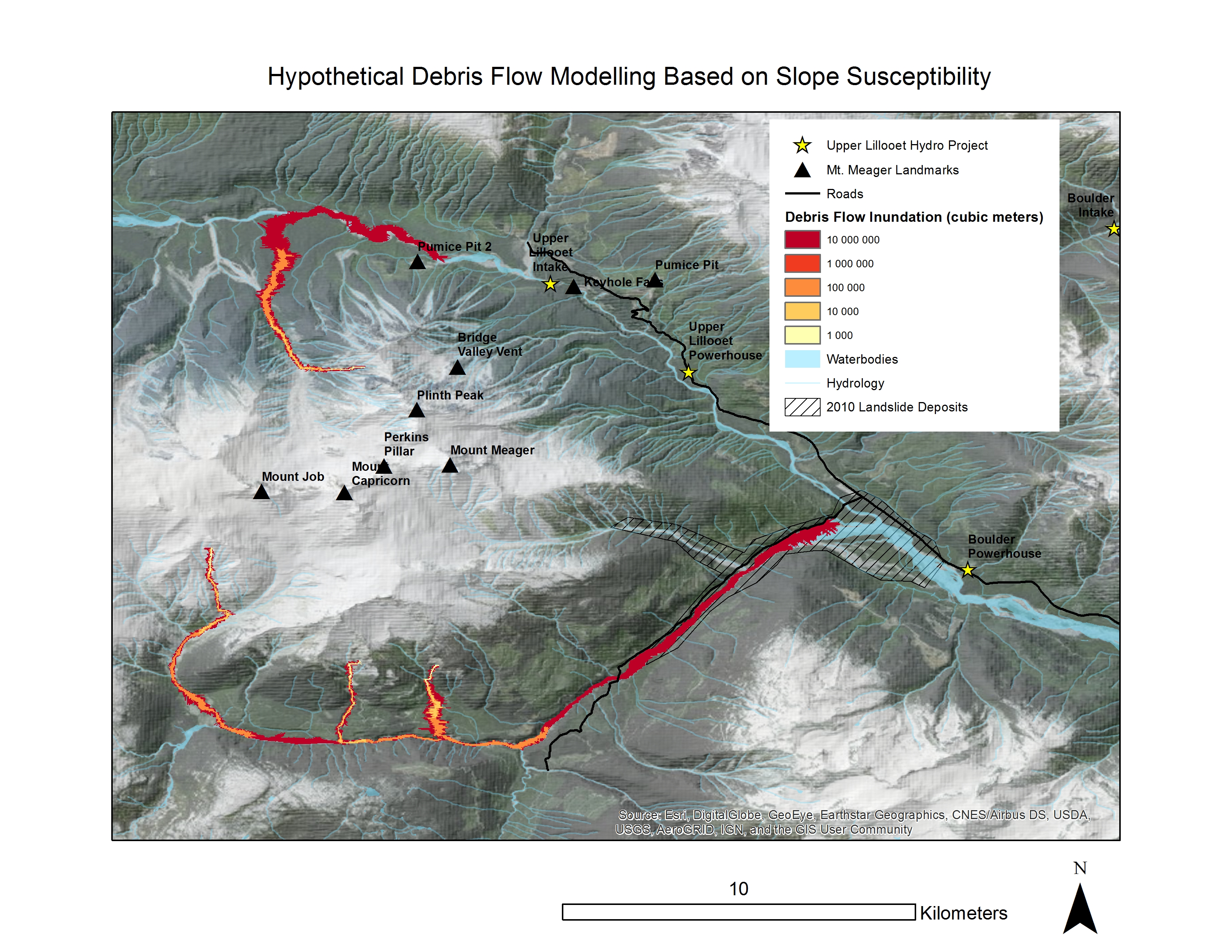
Figure 2: Hypothetical debris flow modelling based on slope susceptibility. Source areas for debris flows chosen based on areas which had the highest susceptibility based on earlier analyses (Fig. 1). Main deposits of the massive 2010 landslide marked by the hashed lines.
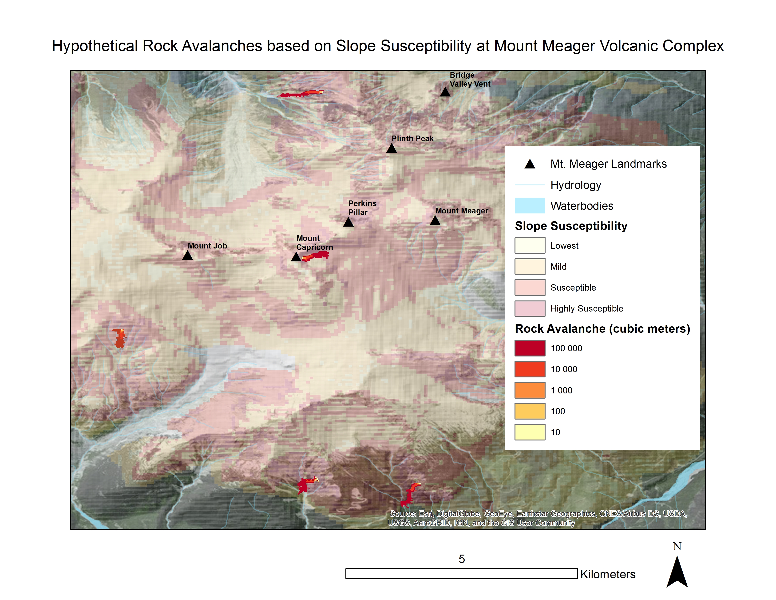
Figure 3: Hypothetical rock avalanches at Mount Meager Volcanic Complex based on slope susceptibility. Note that rock avalanches tend to evolve into debris flows especially if channelized, so any area of slope which may give has severe hazard implications downstream.
The simulations produced here, though much less daunting than the simulations of lahars, provide an example of the potential for destruction that mass movements may have. It is much more difficult to pick exact source points for mass movements, since there is not one clear source like the volcanic vent. As discussed above, I alleviated part of this issue by completing a simple MCE based on lithology and slope, but since I left out several factors the results of the MCE are uncertain (slope stability analysis of the complex merits a project of its own!). Based on the simulations, however, it is clear that a large debris flow (even on the west side of the complex) has the capacity to reach established infrastructure. Movements that occur on the south side of the complex (like in 2010) channelize themselves down Meager Creek, while north side mass movements will follow down tributaries and then down the Lillooet should they grow in size downslope. The map of rock avalanches and slope stability should be used to imagine the massive potential of weak slopes to give, produce a rock avalanche, and channelize themselves into debris flows – the true hazard. It should also be noted that debris flows, if large enough, have the capacity to dam the Lillooet once again like they did in 2010 (especially upstream of Keyhole Falls, where the river is very narrow). Damming of the river could create a dam, and a subsequent catastrophic breach which itself could travel tens of kilometers down the valley in a debris flow-like fashion.