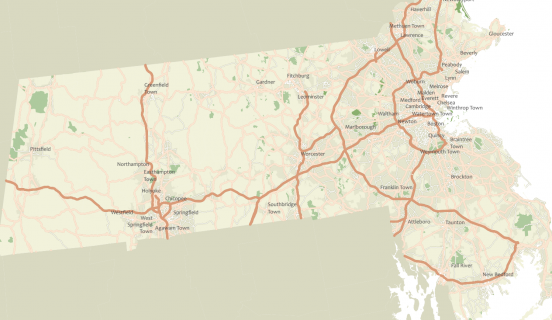
Overview:
A map is a graphic – either static of dynamic – that conveys a geographical story. In other words, a map if a visual thing that communicates spatial things. This exercise focuses on making a small-format reference map of the U.S state of Massachusetts (for printing purposes). Project for ESRI’s Cartography MOOC.
Objectives:
- Understand the mechanics of making a map in ArcGIS Pro
- Explore the ArcGIS Pro user interface, detailed property panes for symbology, labeling and legend elements.
- Work with map, layers, and layout within a project
- Learn how to symbolize and label layers, some basic symbol editing and label placement techniques.
- Set a map projection and reference scale and establish symbol layer drawing
Map: