
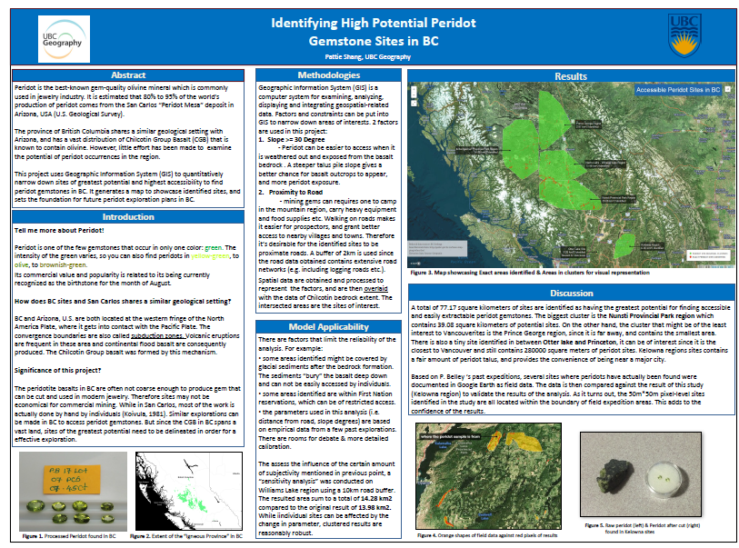
Research Question
Situated in a tectonic setting similar to San Carlos, Arizona where large economical peridot deposits have been discovered, BC also contains considerable coverage of basalt bedrock where peridot gemstones can be found. Can we use GIS to find some promising peridot sites with great rock exposures and good accessibility to individual prospectors?
Goal
Explore gem-quality peridot sites and site clusters in BC using Geographic Information System (GIS). Establish constraints to narrow down rather exact sites inside the vast extent of basalt group bedrock.
Reflect on reliability of analysis using previous field data.
Final Poster (ฅ´ω`ฅ)
Full size: https://drive.google.com/open?id=0B8bwZqR-a9UYLTB4WExWNlF0Qms
Presentation time & location:
6:30 PM – 8:00 PM Thursday, March 23, 2017. Irving K. Barber Learning Centre, Level 2 Main Concourse.
Background: Mineral Composition & Formation
Peridot is a type of olivine → olivine is a group of rock-forming minerals usually found in mafic and ultramafic igneous rocks
Tieing the Chilcotin Group to peridot:
The Chilcotin Group basalt (CGB) is located in the Interior Plateau of British Columbia and covers an area between 36500 to 50000km2 (Andrews & Russell, 2006; Dohaney, 2009; Bevier, 1982). CGB is known to contain olivine-bearing xenoliths, which in turn, implies that there is a possibility of finding a gem-quality peridot occurrence in the area.
Methodology
Mapping gem-occurrence sites through field studies can be difficult and time-consuming work. As in this case, gem-quality mineral distribution can be quite random, and there are no systematic way to pinpoint its occurrence. So we turn to focus on examining its exposure and evaluating its accessibility, to locate sites with the greatest potential of findings.
GIS is the spatial analysis tool that spatial and tabular data in a digital environment to find solution to issues that span vast land. It’s used to manage, transform, analyze data in this study. Carto – an online cartography platform is used to render the results.
Method
- Chilcotin Bedrock Extent in BC
The bedrock that potentially contains gem-quality peridot.
2 Additional Constraints:
Slope
- Establish the sites where peridot are relatively exposed, and can therefore be more accessible to be picked up / mined by individual “miners”
- identified based on previous findings and “expert’s opinion”
- Talus piles
Proximity
- Establish the consideration around accessibility – without mining companies building railroads or road extensions into the mountain area, what are the sites that are close to major roads (<10km) or to local / logging roads (<2km)