Before we began our avalanche analysis, it was essential to investigate the factors that affect avalanche formation in order to better understand the significance of each variable as well as how we would use GIS to locate hazardous terrain using this information. There are six types of avalanches: slab, loose snow, icefall, cornice fall, glide, and slush avalanches. Of these, the slab avalanches are by far the most deadly and account for the majority of backcountry avalanche deaths. A slab avalanche is a “slab” of cohesive snow which slides as a unit over the snow (Avalanche.org, 2020). The main factors which determine how likely a slab avalanche will occur are slope angle, elevation, wind, slope aspect, and slope curvature.
After obtaining and importing the digital elevation model (DEM) data, road files, lake data and wind speed data into our ArcGIS project we were able to begin our analysis. We first calculated slope angle, aspect, and curvature from the DEM, using spatial analysis tools in ArcGIS Pro. Next, we transformed the wind polygon data to a raster file in order for it to be used in the Multi-Criteria Evaluation (MCE) later. A project boundary polygon was then created and the aspect, slope angle, DEM, and wind raster were clipped to the area of interest. We then ensured all the layers were projected using the UTM Zone 10 in order to reduce error. We also performed a resample of the wind speed pixel size in order to match the DEM and to obtain a clearer MCE. The variables could then be reclassified based on the tables below. Finally, the variables were weighted in the MCE (as explained below) and transformed based on the predetermined normalization weights which are also explained below.
Slope Angle:
Slope angle is the most important factor to consider when analysing terrain for avalanche danger. The most dangerous slope angles, which we categorized as extremely dangerous, are between 35-45 degrees in the Coast Range. Below 35 degrees, slopes are still very capable of producing avalanches; however, when slope angles are below 25 degrees, slopes generally tend to be too flat to produce large avalanches. Above 45 degrees, slopes are still capable of producing sluffing events, but the slopes are less dangerous because deep snowpacks are difficult to form due to the large influences of gravity on the extreme slopes (McCammon, 2009).
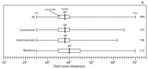
(Figure one: A study of slope angles in different climates with box plots indicating recorded avalanches and how steep the slopes they occurred on were (McCammon, 2009))
Slope Classification:
| Slope Angle (o) | Danger Classification | Weight Assignment |
| 0-25 | Low Danger | 4 |
| 25-30 | Moderate Danger | 10 |
| 30-35 | High Danger | 25 |
| 35-45 | Extreme Danger | 40 |
| 45-50 | Moderate Danger | 15 |
| Over 50 | Low Danger | 6 |
Elevation:
In the backcountry, there are three elevation classification types that concern backcountry snow users: below the treeline (BTL), treeline, and the alpine. BTL is from 0 m-1,300 m in this part of the Coast Range. It is characterized by thick forest cover (Avalanche Canada, n.d.) and is considered the safest backcountry terrain because the trees provide stability. Additionally, the snowpack is relatively protected from the elements such as the wind. The next elevation band is the treeline which is typically between 1,300 m-1,800 m. The treeline is characterized by, “sparse forest cover and is the transition between uniform forest cover below it and the alpine above it” (Avalanche Canada, n.d.). This elevation profile is more prone to slides and is definitely susceptible to being in the runout zone of avalanches that began in that alpine, but similar to the BTL this area is more protected than the alpine zones above. The final elevation band is the alpine which is typically 1,800 m and above in the Coast Range. The alpine is characterized by, “wide expanses of open, exposed terrain with few or no trees” (Avalanche Canada, n.d.). The alpine is by far the most dangerous elevation band and the one which produces the largest and most frequent avalanches.
We ranked our three elevations below and weighted them based on how likely the elevation was to produce an avalanche:
Elevation Classification:
| Elevation (Meters) | Danger Classification | Weight Assignment |
| 0-1300 | No Danger | 10 |
| 1300-1800 | Slight Danger | 30 |
| 1800+ | High Danger | 60 |
Wind:
The wind is another important element which can have a significant effect on creating a snowpack susceptible to avalanches. Wind from the windward side of an obstacle, such as a ridge, transports snow and deposits it on the leeward (downwind) side of the terrain, leading to wind loading in areas. These deposits typically develop wind slabs which are dense slabs of deposited snow that are very unstable. Wind loading is a common denominator in most avalanche accidents (Avalanche.org, 2020).
In our study, we could only locate average wind speed data for BC. The data also had no vector associated with it, meaning we could not determine where wind loading would occur. Although we couldn’t determine wind direction, areas, where wind speeds were higher, could still indicate higher avalanche danger.
Wind Classification:
| Wind speed (m/s) | Danger Classification | Weight assignment |
| 1.46-2.77 | Least Danger | 5 |
| 2.77-4.08 | Little Danger | 10 |
| 4.08-5.39 | Moderate Danger | 17 |
| 6.70-6.7 | High Danger | 28 |
| 6.7+ | Most Danger | 40 |
Aspect:
Aspect can be a significant factor in predicting avalanche-prone terrain. However, it is far from a perfect indicator because, throughout the year as the weather and seasons change, the aspect that is unstable may be different from what would be expected. In early and midwinter, in the northern hemisphere, the northern and northwestern aspects, receive significantly less sun than the southern aspects. This can limit the amount these slopes are able to consolidate leading to an increased risk of avalanche (Avalanche Canada, n.d.). In the late spring, however, the opposite can be true; southern aspects can become particularly unstable to wet slides because of intense solar radiation. In our study, we are going to focus on mid-winter. We chose to weight all of the aspects somewhat similarly because the slope aspect instability can vary so significantly, even within a single day.
Aspect Classification
| Aspect (Degrees) | Danger Classification | Weight Assignment |
| 280-360 (NW) | Most Dangerous | 40 |
| 0-90 (NE) | Moderate Danger | 30 |
| 180– 280 (SW) | Slight Danger | 20 |
| 90-180 (SE) | Low Danger | 10 |
Convexity and Concavity:
The curvature of the slope is also an important element of avalanche terrain evaluation. Convex terrain is well documented as being particularly problematic for avalanches. Slab avalanches can form and propagate along convex terrain, so particular caution must be taken when backcountry users identify convex terrain around them. In our study, the DEM we could acquire had a spatial resolution of 20m. After creating a curvature layer in ArcGIS we realized this resolution was too low to generate a curvature map of high enough quality for this project. Thus, we chose to ignore this important element of avalanche evaluation for this project; however, it would be an important addition to follow up research, if DEM data with a higher spatial resolution could be obtained.
Analytic hierarchy process (AHP):
An AHP was used to determine the weight of each variable being used in the Suitability Modeler. The process determines the relative importance of each factor once each factor has been compared to all the others. They were compared with respect to their ability to affect avalanche risk. The weights obtained by the AHP are shown below. We also performed a sensitivity analysis by altering the weights to determine how sensitive the results are to the chosen parameters. After applying equal weights to each layer, we found that the map produced was not significantly different, thus we chose not to include it in our results.
MCE Weights:
| Factor | Weight |
| Slope | 0.44 |
| Elevation | 0.29 |
| Wind | 0.16 |
| Aspect | 0.11 |