
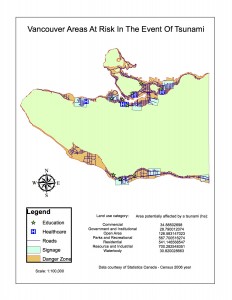
Percentage of total Vancouver area which is in danger in the event of a tsunami:
By accessing the “Statistics” window for the attribute table for the Vancouver_Danger layer I found the sum of the “Shape_Area” to be 20314805.867912 m^2. By accessing the attribute table for the Vancouvermask layer I found the “Shape_Area” to be listed as 131033339.950334 m^2. As the Vancouvermask layer represents the total area of the City of Vancouver and the Vancouver_Danger layer represents the area affected in the event of a Tsunami we can calculate the percentage of the City of Vancouver’s total area which is in danger as:
[(20314805.867912 m^2)/(131033339.950334 m^2)] x 100%= 15.50353969%
Healthcare and educational facilities within the Vancouver danger zone:
Educational facilities within the City of Vancouver danger zone:
EMILY CARR INSTITUTE OF ART & DESIGN (ECIAD), INSTITUTE OF INDIGENOUS GOVERNMENT (IIG), HENRY HUDSON ELEMENTARY, FALSE CREEK ELEMENTARY, ST FRANCIS XAVIER, VANCOUVER MONTESSORI SCHOOL, ST JOHN’S INTERNATIONAL, HERITAGE 3R’S SCHOOL, ST ANTHONY OF PADUA, ECOLE ROSE DES VENTS,
Health care facilities within the City of Vancouver danger zone:
FALSE CREEK RESIDENCE, VILLA CATHAY CARE HOME, COAST WEST COMMUNITY HOME, BROADWAY PENTECOSTAL LODGE, YALETOWN HOUSE SOCIETY
To get these answers I used “selection by location” to select features from Vancouver_Healthcare and Vancouver_Education with the source layer of Vancouver_Danger. I then clicked on “Data” for each layer and used the “Export Data” function to export “selected features” and create a new layer for each of the healthcare and education facilities within the Vancouver danger zone. I checked the results visibly by turning on and off the selected features in the Vancouver_Healthcare and Vancouver_Education layers.