Monthly Archives: October 2017

GEOG 481 Blog 3 – Foreign Exchanges: Emigration From Japan

Although not considered a nation many would emigrate from, Japan, like many countries around the globe has often been the point of origin of citizens spanning many nations, namely in Asia, North America, and South America. The patterns of these emigrational flows are products of history as much as they are of geography, and revolve primarily around geo-political relations, and economic incentives. They are dichotomized, however, by region. As emigration to the Americas, and to Asia is based on fundamentally distinct power dynamics between Japan and those respective regions.

The Americas

The early twentieth century was characterized by several waves of emigration of Japanese laborers, to Hawaii, California, and British-Columbia. These emigrants were known as dekasegi. These destinations changed however, as Japanese sentiment during the period before the Second World War prompted emigrants to shift their prospects from North-America to South-America, namely Brazil and Peru. These migrations ceased with the outbreak of the war, as Canada, the United-States, and Latin American countries closed their borders to Japan. By 1940, about 500,000 Japanese migrants and their descendants were estimated to be living in North and South-America.

The end of the Second World War reopened formal relations between Canada, the United-States, and Latin American countries with Japan. A small number of Japanese migrants made way for the U.S., Canada, Paraguay, Brazil, and Argentina in the immediate aftermath of WWII. These migrations reflected Japan’s post-war devastation, as a lack of employment opportunities, a result of the destruction of key economic centers, coupled with the restrictions enacted under the unconditional surrender, effectively incapacitated the nation and its populace. At its peak, Japanese emigration exceeded 15,000 migrants in 1958. As the Economic Miracle began to take form, these numbers started to dwindle. In 2000, 790,000 Japanese emigrants were permanent residents of the nations they migrated to, of this, around 36% resided in the United-States, and 12% in Brazil. In total, some 1.4 million Japanese emigrants lived abroad in 2000, 670,000 in the U.S., 1.3 million in Brazil, and 80,000 in Peru.

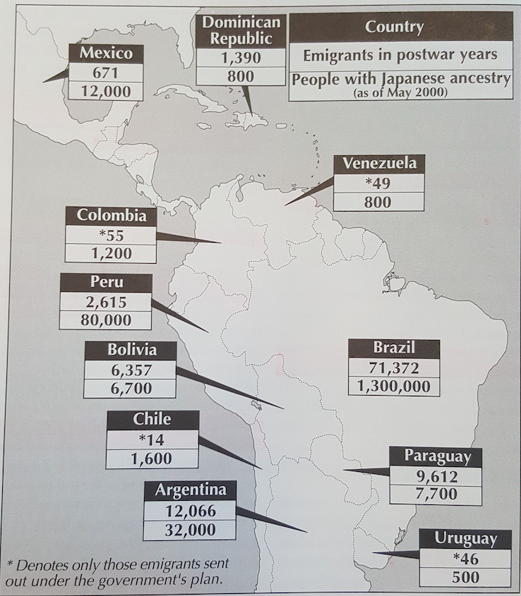
fig. 1. A map detailing the number of Japanese emigrants living in Latin America, divided by post-war emigrants and people with Japanese ancestry as of May, 2000

In an attempt to manage the war-ravaged economy and 6 million civilians and military personnel repatriated from former Japanese colonies and occupied territories in Asia, the Japanese government made attempts to encourage emigration. Central and South American countries were considered to be ideal candidates for emigration, as these nations had a storied history of Japanese settlement. The social infrastructure of previous Japanese settlers existed in these countries, and more importantly during the post-war atmosphere, little anti-Japanese sentiment existed in them. Despite this, many Japanese settlers faced unfavorable conditions and a lack of infrastructure in Latin American countries. Worse yet, the Japanese government did little in addressing these concerns or raising them with foreign diplomats. In 1951, the Brazilian government agreed to accept 5000 Japanese families for emigration into the Amazon region. To aid with emigration efforts, the Japanese government created the Federation of Japan Overseas Associations, setting up a special government corporation to extend soft loans for emigration with funds borrowed from American banks. Under the organization, and ten year emigration plan was devised to send out 426,000 emigrants. This process was anything but smooth, however, as the interministry struggle for leadership between the Foreign Ministry and Agriculture and Forestry Ministry hindered the development of infrastructure needed to improve the land designated to emigrants. The first wave of post-war migrants arrived to the Amazon region in 1953. Less than a month after their arrival, however, many of the emigrant families had deserted their assigned settlements. In total, some 6000 Japanese citizens emigrated to the Amazon region during the postwar era. In 2000, around 13,000 people of Japanese descent lived in the region, located in three settlements: Guama, Quinari, and Bela Vista.

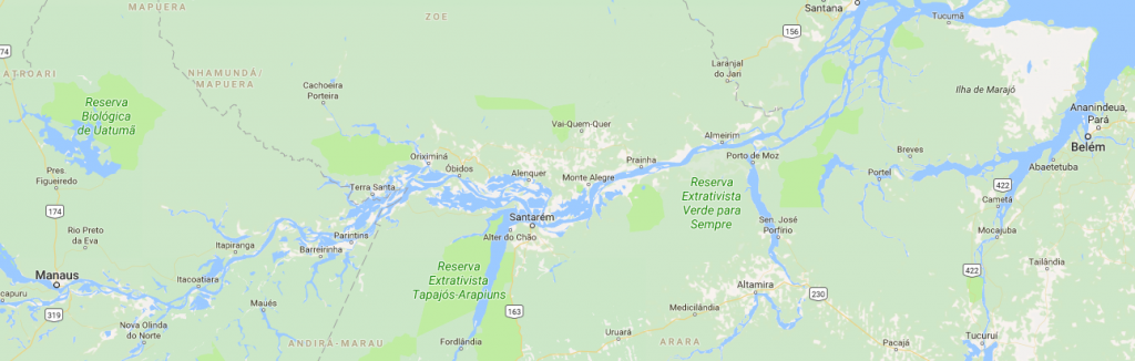
fig. 2. A Map of the Amazon River detailing some of the settlements Japanese emigrants migrated to in 1953, in this map Belem and Manaus are visible

Asia

In response to the end of relations with American countries, Japanese laborers emigrated to newfound colonies and territories, such as southern Sakhalin, Taiwan, Korea, and Manchukuo. This was done to alleviate population pressure faced in Japan and to provide relief from the economic depression that had spread since the early 1930’s. In the period between 1929 and 1937, Japanese migrants to Manchukuo increased from 814,000 to around 1.8 million. This was reciprocated with a considerable influx of Korean and Chinese migrants into Japan. Between 1942 and 1945, around 4 million people left Japan (military and civilian) for Manchukuo. To offset this massive drop in population, Japan forcefully migrated some 400,000 Koreans to meet labor shortages. The end of the war ended this emigration/migration flow, however, as roughly 5.7 million Japanese returned to Japan, and 1.2 million Korean and Chinese migrants were returned to their respective countries.

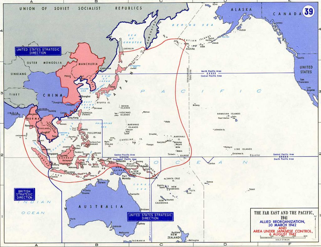
fig. 3. A map detailing the extent of the Japanese Empire, at its height, in 1942

Sources:

Karan, Pradyumna P. “Japan In the 21st Century: Environment, Economy, and Society”. The University Press of Kentucky, 2005. p.187 – 190

Header image: http://d-maps.com/carte.php?num_car=3264&lang=en

fig. 1. Karan, Pradyumna P. “Japan In the 21st Century: Environment, Economy, and Society”. The University Press of Kentucky, 2005. p. 188

fig. 2. Google Maps

fig. 3. http://www.emersonkent.com/map_archive/pacific_1942.htm

GEOG 481 Blog 2 – Disaster Early Warning Systems & the 2020 Olympic Games

Due to its location on the Pacific Rim, Japan is an island nation with a storied history of being inundated by natural disasters. The nation has experienced, and proven, its resilience through a myriad of typhoons, earthquakes, and tsunamis. Each event proves as a valuable learning opportunity, wherein the nation’s defenses, and disaster mitigation strategies are retooled to be more effective. An integral part of this disaster mitigation strategy are Japan’s preventive early warning systems. These systems detect and give warnings in the event of both earthquakes and tsunamis, and stand as the most advanced on Earth. Pushed to their limits during the 2011 Tohoku Triple Disaster, the two systems will play an important part in ensuring safety during the 2020 Olympic and Paralympic games in Tokyo.

fig. 2. A tectonic map of the North-East Pacific, detailing the fault lines Japan rests on

Kinkyu Jishin Sokuho

Launched on October 1st, 2007, the Japan Meteorological Agency provides residents with earthquake early warnings. This system is formally known as the EWS and collects seismic data from a network of over one thousand seismographs, nationwide. It provides estimates of seismic intensities along with a rough arrival time of principle motion, derived from wave data near the epicenter. What sets it apart from most detection centers, however, is the fact that the data is then used to alert instant warnings. These include texts messages, alerts on television and radio networks, and the automatic slowing down and stoppage of trains, elevators, and factories. The extent to which this system has been integrated into Japanese life will prove valuable in the event of an earthquake during the games.

However, the system is not without its flaws. Primarily, the time between initial detection, and the main tremor is a matter of seconds if not tenths of seconds. Moreover, magnitude estimation along with seismic intensity estimation can be flawed. The system has issues with differentiating between simultaneous yet separate events. Furthermore, the greater the intensity, the harder it is for the system to provide a magnitude estimate. Drawing on data from individual seismographs can likewise be risky, as accidents, lightning, or systemic failures can trigger false alarms. In a scenario wherein strategies must be formulated within seconds, these errors can make the difference between survival and catastrophic loss of life.

Deep-ocean Assessment and Reporting of Tsunami (DART®) stations

The DART system, developed by the National Oceanic and Atmospheric Administration (NOAA), in the United-States, serves as the second pillar of Japan’s Tokyo 2020 early warning and disaster mitigation strategy. The system, comprised of over thirty-nine buoy-mounted detection systems, measures ocean pressure in tandem with sea-surface height estimates, to provide advanced warnings on developing tsunamis. Each detection system consist of an anchored seafloor bottom pressure recorder (BPR) attached to a moored surface buoy, for real-time communication. An acoustic link transmits the data from the BPR to the surface buoy. The BPR collects temperature and pressure measurements at 15-second intervals, and these pressure values are corrected for temperature effects. The pressure is then converted to an estimated sea-surface height (height of ocean surface above seafloor), by using constant 670 mm/psi. DART uses two reporting modes; event and standard. Operating routinely in standard mode, four spot values of the regular 15-second interval data are collected and reported during the scheduled transmission times. Once the internal detection software identifies an anomaly, the system ceases standard operation and enters event mode. In event mode, the system transmits 15-second interval data while providing 1-minute averages. It also records the initial time of the anomaly, in the event that an estimated time between tsunami formation and landfall is calculated. The system does not return to standard mode until 4 continuous hours of regular 1-minute averages have been recorded.

fig. 1. A diagram of the DART II System

Given Japan’s location on the North American, Pacific, Eurasian, and Philippine tectonic plates, the nation (and its detection systems) are used to tectonic activity. Regardless, this has not made Japan apathetic to even slight tremors, but more watchful of any sized events. Most Olympic committees fear political turmoil or terrorist activity may harm the success of their games. Tokyo 2020’s committee must worry about human factors in tandem with the high-possibility of a tectonic related disaster. As the wounds of the 2011 Triple Disaster have yet to heal, it will be interesting to see how the island nation will respond in the horrifying event of a major earthquake, or tsunami during the Olympic Games.

 Sources:

Japan Meteorological Agency. Earthquake Early Warning System, 2017, http://www.jma.go.jp/jma/en/Activities/eew.html.

Knight, Will. “How Japan’s Earthquake and Tsunami Warning Systems Work.” MIT Technology Review, 11 March, 2011, https://www.technologyreview.com/s/423279/how-japans-earthquake-and-tsunami-warning-systems-work/

Talbot, David. “Intelligent Machines: 80 Seconds Of Warning For Tokyo .” MIT Technology Review, 11 March, 2011, https://www.technologyreview.com/s/423274/80-seconds-of-warning-for-tokyo/

Birmingham, Lucy. “Japan’s Earthquake Warning System Explained.” TIME, 18 March, 2011, http://content.time.com/time/world/article/0,8599,2059780,00.html

Kumagai, Jean. “In Japan Earthquake, Early Warnings Helped.” IEEE Spectrum, 15 March, 2011, https://spectrum.ieee.org/tech-talk/computing/networks/japans-earthquake-earlywarning-system-worked

McCurry, Justin. “Olympic Task: Tokyo is already in crisis management mode for 2020 games.” The Guardian, 1 September, 2016, https://www.theguardian.com/public-leaders-network/2016/sep/01/tokyo-2020-olympic-games-crisis-management-earthquakes

(Figure. 1.) National Oceanic and Atmospheric Administration. Deep-ocean Assessment and Reporting of Tsunamis (DART) Description, 2017, http://www.ndbc.noaa.gov/dart/dart.shtml

(Figure. 2.) http://academic.emporia.edu/aberjame/tectonic/japan/japan.htm

(Featured Image) http://www.navy.mil/view_image.asp?id=98323


GEOG 481 Blog 1 – What Prompted the Meiji Restoration?

Following roughly two and a half centuries of Tokugawa Bakufu rule, Japan rapidly transformed itself into one of the world’s preeminent powers, in a transition that occurred “overnight” in historical terms. This transition, historic in both its pace and effectiveness, can be understood as the result of a number of interconnected central factors, most prominent being China’s fate during the mid-19th century, Commodore Mathew C. Perry’s “gunboat diplomacy” and the larger implications of the treaty of Kanagawa, as well as the general discontent of several daimyo towards the Bakufu system.

Fig. 1. Tokugawa Iemochi, the 14th Shogun of the Tokugawa Bakufu, ruling from 1858 – 1866

Matthew C. Perry & The Treaty of Kanagawa

Following the signing of the Treaty of Nanking, in 1842, the United-States wanted to join nations such as Britain in carving up trade opportunities and ports in China. Naturally, sailing from California, Japan is located directly on the route to China. Moreover, the North Pacific was home to thousands of whales, prompting hundreds of American whalers to hunt in these waters. These two factors of geography prompted the United-States to seek trade opportunities with the Tokugawa Bakufu, initially requesting that the Bakufu open its ports to sell coal, food, and water to American ships, and to provide emergency aid to distressed American crews near Japan. Eleven ears after the Treaty of Nanking, on July 8th 1853, Matthew C. Perry, an American navy commodore on orders from President Millard Filmore, sailed into Edo Bay to deliver a letter requesting that Japanese foreign trade be resumed. After delivering the letter, Perry left, promising to return within a year for a reply to the President’s request. On the 14th of February, 1854, Perry returned with an eight-ship armada, leveeing the threat of force against the Tokugawa Bakufu, effectively forcing an agreement to be signed. On March 31st, 1854, Japan signed the Treaty of Kanagawa (Yokohama), which opened two ports, Shimoda and Hakodate, to shipwrecked American sailors and American trade. This prompted Britain, Russia, and France to all sign similar agreements, each completed before 1856.

Fig. 2. Commodore Matthew C. Perry and his Armada, on orders from the President, arrive in Edo Bay (1854)

The Modernization Impetus 

These treaties expanded the Japanese’s understanding of the world around them. The nation was impressed by American technological superiority, and the Japanese soon realized that in order to avoid the fate of China, they would need to modernize. Many began to realize that the Tokugawa, which had ruled Japan for centuries, were inept at facing the challenges of the 19th century. In order for Japan to survive, thus modernizing, it would have to do away with the system of military governance of the past. In 1868, leaders from the two remote southern domains of Satsuma and Choshu seized the Imperial Palace in Kyoto in an effort to restore the power of the Meiji emperor. Merely fourteen years after the Treaty of Kanagawa, the Tokugawa Bakufu, ruling for over two centuries, was brought to a sudden end. Japanese leaders began reorganizing the nation, sending convoys the world over to study all facets of modern life in nations around the globe. With this data, Japan adopted practices similar to many western nations, including American business practices, French legal systems, British naval structure, and most importantly, Germany’s authoritarian military-machine. Japan modelled itself most closely along the lines of Bismarck’s empire.

Success of Modernization & Its Effects Pre-WWI

Toshio Mizuuchi, an Osaka-based geographer, has attributed the rapidly successful modernization of Japan, in all aspects, to the proper execution of development policies and the establishment of transportation facilities. He notes five specific policies as being central to this transition:

  1. Policy of river & flood control, and water resource management
  2. Road construction & maintenance
  3. Harbour construction & maintenance
  4. Railway construction
  5. Policy of city &  regional planning

Bearing these policies in mind, Japan’s remarkably efficient transition from a quasi-feudal state, into a modern world power begins to make sense. In 1894, a mere 26 years after the Meiji Restoration, Japan attacked China, forcing an indemnity payment, the release of Korea, later annexed by the Japanese in 1910, and the release of Taiwan (then referred to as Formosa). Ten years later, in 1904, Japan attacked Russia, shocking the world by winning the war on both land and sea. If Japan’s victory over China turned heads, her victory over Russia forced world powers to take note that not only had Japan become an economic power, but a prominent military force as well. Japan seized the southern half of Sakhalin Island, and Russia’s railroad and port concessions in southern Manchuria.

fig. 3. Japanese soldiers decapitate Chinese POW’s during the First Sino-Japanese War. (Utagawa Kokunimasa, October 1894)

Driven by a fear of annexation, and fuelled by a desire to modernize, the end of Tokugawa rule and the Bakufu system, resulted in the creation of a modern economic & military superpower in Japan. Her rapid succession, all these years later, still challenges most understandings of national transition, however, as history has shown, this desire for superiority would have disastrous consequences for East-Asia, and eventually, Japan itself.

Sources

Gordon, Andrew. “A Modern History of Japan”. Oxford University Press, 2014. P.47-55.

Karan, Pradyumna P. “Japan In the 21st Century: Environment, Economy, and Society”. The University Press of Kentucky, 2005. P. 61-63.

Figure 1: https://commons.wikimedia.org/wiki/File:Toku14-2.jpg

Figure 2: https://commons.wikimedia.org/wiki/File:Визит_Перри_в_1854_году.jpg

Figure 3: https://ocw.mit.edu/ans7870/21f/21f.027/throwing_off_asia_01/2000_380_07_l.html