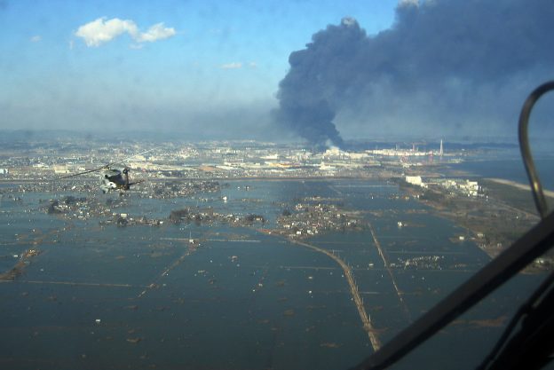
Due to its location on the Pacific Rim, Japan is an island nation with a storied history of being inundated by natural disasters. The nation has experienced, and proven, its resilience through a myriad of typhoons, earthquakes, and tsunamis. Each event proves as a valuable learning opportunity, wherein the nation’s defenses, and disaster mitigation strategies are retooled to be more effective. An integral part of this disaster mitigation strategy are Japan’s preventive early warning systems. These systems detect and give warnings in the event of both earthquakes and tsunamis, and stand as the most advanced on Earth. Pushed to their limits during the 2011 Tohoku Triple Disaster, the two systems will play an important part in ensuring safety during the 2020 Olympic and Paralympic games in Tokyo.
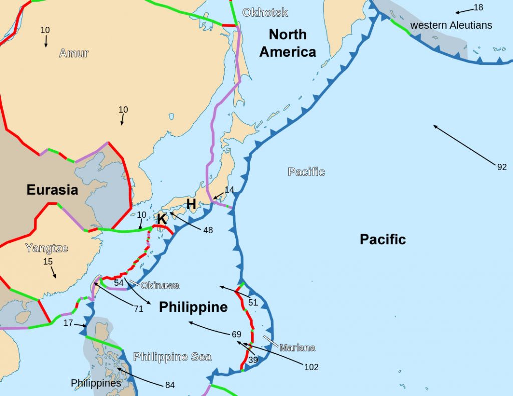
fig. 2. A tectonic map of the North-East Pacific, detailing the fault lines Japan rests on
Kinkyu Jishin Sokuho
Launched on October 1st, 2007, the Japan Meteorological Agency provides residents with earthquake early warnings. This system is formally known as the EWS and collects seismic data from a network of over one thousand seismographs, nationwide. It provides estimates of seismic intensities along with a rough arrival time of principle motion, derived from wave data near the epicenter. What sets it apart from most detection centers, however, is the fact that the data is then used to alert instant warnings. These include texts messages, alerts on television and radio networks, and the automatic slowing down and stoppage of trains, elevators, and factories. The extent to which this system has been integrated into Japanese life will prove valuable in the event of an earthquake during the games.
However, the system is not without its flaws. Primarily, the time between initial detection, and the main tremor is a matter of seconds if not tenths of seconds. Moreover, magnitude estimation along with seismic intensity estimation can be flawed. The system has issues with differentiating between simultaneous yet separate events. Furthermore, the greater the intensity, the harder it is for the system to provide a magnitude estimate. Drawing on data from individual seismographs can likewise be risky, as accidents, lightning, or systemic failures can trigger false alarms. In a scenario wherein strategies must be formulated within seconds, these errors can make the difference between survival and catastrophic loss of life.
Deep-ocean Assessment and Reporting of Tsunami (DART®) stations
The DART system, developed by the National Oceanic and Atmospheric Administration (NOAA), in the United-States, serves as the second pillar of Japan’s Tokyo 2020 early warning and disaster mitigation strategy. The system, comprised of over thirty-nine buoy-mounted detection systems, measures ocean pressure in tandem with sea-surface height estimates, to provide advanced warnings on developing tsunamis. Each detection system consist of an anchored seafloor bottom pressure recorder (BPR) attached to a moored surface buoy, for real-time communication. An acoustic link transmits the data from the BPR to the surface buoy. The BPR collects temperature and pressure measurements at 15-second intervals, and these pressure values are corrected for temperature effects. The pressure is then converted to an estimated sea-surface height (height of ocean surface above seafloor), by using constant 670 mm/psi. DART uses two reporting modes; event and standard. Operating routinely in standard mode, four spot values of the regular 15-second interval data are collected and reported during the scheduled transmission times. Once the internal detection software identifies an anomaly, the system ceases standard operation and enters event mode. In event mode, the system transmits 15-second interval data while providing 1-minute averages. It also records the initial time of the anomaly, in the event that an estimated time between tsunami formation and landfall is calculated. The system does not return to standard mode until 4 continuous hours of regular 1-minute averages have been recorded.
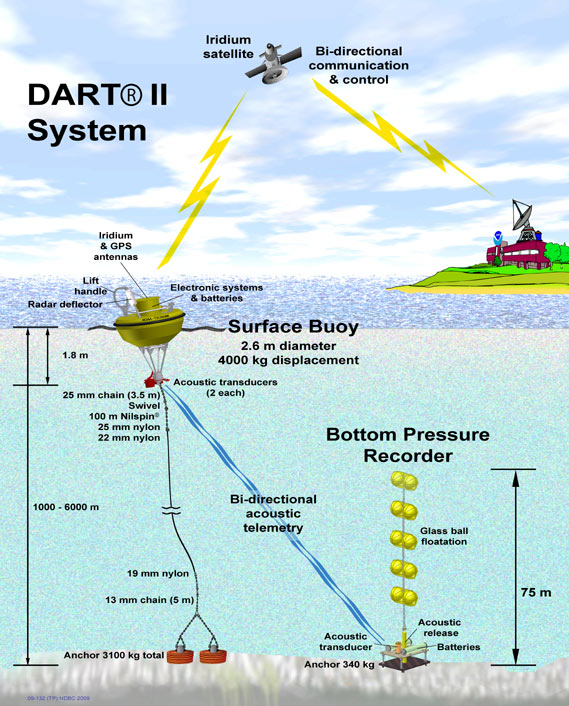
fig. 1. A diagram of the DART II System
Given Japan’s location on the North American, Pacific, Eurasian, and Philippine tectonic plates, the nation (and its detection systems) are used to tectonic activity. Regardless, this has not made Japan apathetic to even slight tremors, but more watchful of any sized events. Most Olympic committees fear political turmoil or terrorist activity may harm the success of their games. Tokyo 2020’s committee must worry about human factors in tandem with the high-possibility of a tectonic related disaster. As the wounds of the 2011 Triple Disaster have yet to heal, it will be interesting to see how the island nation will respond in the horrifying event of a major earthquake, or tsunami during the Olympic Games.
Sources:
Japan Meteorological Agency. Earthquake Early Warning System, 2017, http://www.jma.go.jp/jma/en/Activities/eew.html.
Knight, Will. “How Japan’s Earthquake and Tsunami Warning Systems Work.” MIT Technology Review, 11 March, 2011, https://www.technologyreview.com/s/423279/how-japans-earthquake-and-tsunami-warning-systems-work/
Talbot, David. “Intelligent Machines: 80 Seconds Of Warning For Tokyo .” MIT Technology Review, 11 March, 2011, https://www.technologyreview.com/s/423274/80-seconds-of-warning-for-tokyo/
Birmingham, Lucy. “Japan’s Earthquake Warning System Explained.” TIME, 18 March, 2011, http://content.time.com/time/world/article/0,8599,2059780,00.html
Kumagai, Jean. “In Japan Earthquake, Early Warnings Helped.” IEEE Spectrum, 15 March, 2011, https://spectrum.ieee.org/tech-talk/computing/networks/japans-earthquake-earlywarning-system-worked
McCurry, Justin. “Olympic Task: Tokyo is already in crisis management mode for 2020 games.” The Guardian, 1 September, 2016, https://www.theguardian.com/public-leaders-network/2016/sep/01/tokyo-2020-olympic-games-crisis-management-earthquakes
(Figure. 1.) National Oceanic and Atmospheric Administration. Deep-ocean Assessment and Reporting of Tsunamis (DART) Description, 2017, http://www.ndbc.noaa.gov/dart/dart.shtml
(Figure. 2.) http://academic.emporia.edu/aberjame/tectonic/japan/japan.htm
(Featured Image) http://www.navy.mil/view_image.asp?id=98323