Results
The map below shows the results of the Multi Criteria Evaluation. There are two main areas of interest highlighted in green that show the sites with the highest suitability for a new well. One potential site is in the northwest of the Sechelt municipality, and the other is in the central-east.
These areas have fulfilled the criteria regarding a large underlying aquifer (hence higher water resource potential), low cost of establishment, low levels of disruption, low risk of contamination and great accessibility. Both sites have an existing water main going through the area and it would therefore be relatively easy and less costly to connect the new well to the water main network. Another beneficial characteristic of these sites is that they are in areas with a soil type of high porosity which can hold large volumes of water, and additionally they have high precipitation levels, low slope and a surface flow leading towards them hence more water accumulation.
Furthermore, both areas are located far from any other big well thereby reducing the stress inflicted to the aquifer and increasing the potential of the well to supply a large amount of households in the long-term. By situating the well in an area that can sustain a large level of water extraction, the impact on local wildlife and the water table will also be reduced. This is because excessive extraction of water, faster than it can be recharged, leads to a range of negative impacts such as lowering of the water table, reduction of water in streams and lakes, loss of riparian vegetation and wildlife habitat, and land subsidence (USGS, 2013).
Unfortunately we do not have exact information on the size of the aquifer, the actual volume of recharge nor the water supply deficit in summer, therefore we are unable to calculate whether a single well would be enough to completely solve the issue of water insecurity or specifically how much water this well would need to provide. Despite this, the map is very useful in determining the potential sites for a new large-scale well to assist the Sunshine Coast Regional District in their decision making. Hence, the map can be used in further planning efforts to improve year-round water supply for the businesses and residents of Sechelt.
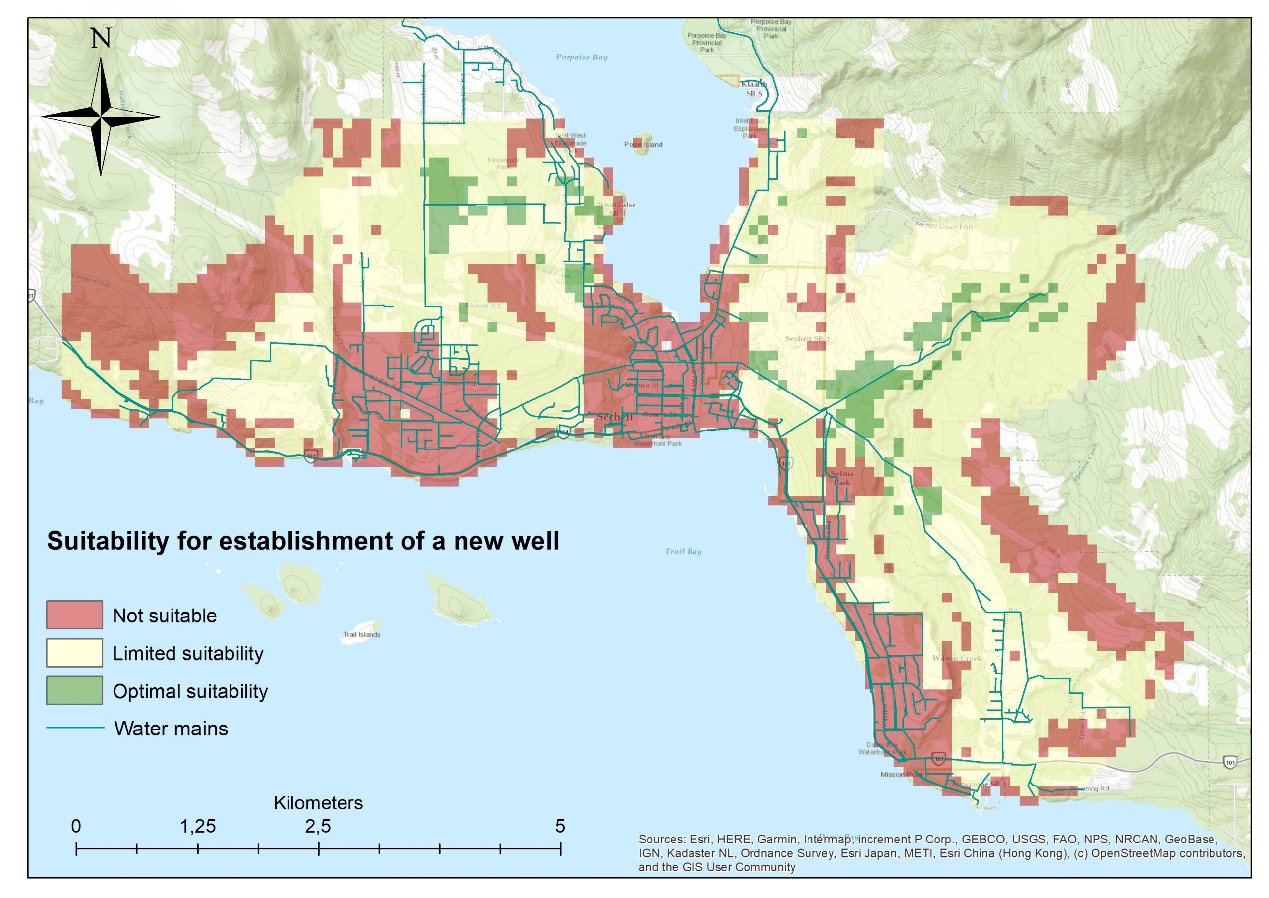
Map of site suitability for a new well in the municipality of Sechelt (Source: ArcMap)
(PDF version of the final map available here)
Discussion
One of the most important factors in the MCE was the land cover, however this data is relatively old and so there is a level of uncertainty associated with it. We decided to investigate this further to see if there has been any development in recent years that has not been included in our analysis.
When looking at a satellite photo from Google Maps, it can be seen that the area in the central-eastern part of the municipality, which was identified by our MCE as a suitable site for the new well, is actually part of a gravel pit, indicated by a red circle. The extent of this gravel pit had not been adequately represented in the land cover data we had obtained, and so unfortunately this area can no longer be considered suitable.
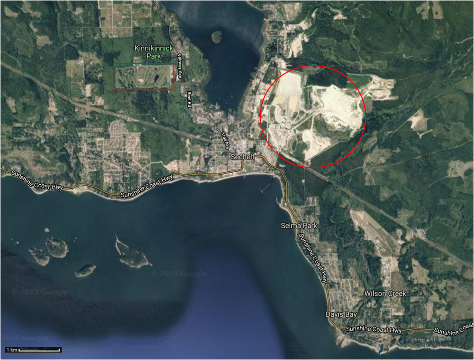
Satellite picture of the municipality of Sechelt showing the gravel pit and golf course (Source: Google Maps)
Removing this area as a potential site for the well leaves only the northwestern site. Investigating this further, we found that it is in close proximity to a golf course, indicated by a red rectangle in the image above, however the northern part of the site is outside the golf area and covered by forest leaving this as the optimal place to situate a new well. There might also be some smaller areas in the eastern part of the municipality. Additionally, we do not have any information regarding the pollution sources from this golf course however it is possible that the lawns are maintained with fertiliser and so there may potentially be a higher concentration of nitrogen in the groundwater in this area.
When we constructed the land cover map, the urban area was set as the ‘least wanted’ land cover type due to possible pollution sources and the higher cost of establishing a site within such urban areas. However, the pollution could potentially extend past the physical limits of the urban area and be gradually decreasing with increased distance, therefore an additional buffer around urban areas could have improved the accuracy of the investigation.
Another consideration to highlight is that of the coarse resolution of the data, specifically of the input raster data sets which were 100m x 100m. This is relatively large considering we want to locate a site for a well that might only require 5m x 5m. When all vector layers were converted to raster layers the resolution was set to 5m in order for the buffers to be displayed correctly as raster, but the high resolution of these layers is lost in the final analysis due to the lower resolution of the precipitation and DEM layer which was 100m x 100m to start with. At the same time there are larger uncertainties associated with the analysis leaving the issue regarding the resolution as a less meaningful problem.
Some of the larger uncertainties affecting the MCE include the way in which the weights were assigned. Whilst the weights we chose were supported by a general understanding from literature of the conditions favourable for well construction, we could have improved the reliability of the weights by conducting a spatial regression analysis. This would have provided information regarding the spatial relationship between each factor and the location of existing wells, which would have highlighted the factors which have the strongest relationship with the distribution of current wells hence should be given a higher weighting. Additionally, many of the classification choices were based on the distribution of the data, logic or other arbitrary reasoning. This might therefore be our largest uncertainty and is important to consider.
Additional points to consider in reference to our MCE results include the fact that many of the map layers are from different years and therefore not equally as updated or relevant, some data needed to be extrapolated which has its own associated uncertainty, and in general the data was gathered from many different places and were all potentially affected by a possible bias from those collecting the information having their own mandates, data quality control checks etc.
To sum up, our general approach to this project has made it relatively simplified but was required to enable us to reach a purposeful conclusion regarding the most-suitable potential sites for a new well and has kept the analysis understandable and transparent.