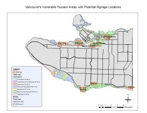
Created using ArcGIS in order to answer a few key questions regarding Tsunami Hazard Areas in Vancouver:
Q: What percentage of the city of Vancouver’s total area is under danger?
A: Total Vancouver Area: 131,033,339 Sq. Meters
Total Area Vancouver Danger Zone: 20,314,806 Sq. Meters
Total Percentage of Vancouver’s area that lies within Hazard Zone: 15.5%
I obtained these numbers through combining spacial attributes into layers and examining attributes for each layer corresponding to potential tsunami threat. This examination produced a number of useful statistics relating to both the total area of Vancouver and the area that lies within hazard zones.
Q: List the healthcare and educational facilities within the Vancouver danger zone.
A: Education in the Danger Zone:
ST ANTHONY OF PADUA
ECOLE ROSE DES VENTS
HERITAGE 3R’S SCHOOL
VANCOUVER MONTESSORI SCHOOL
FALSE CREEK ELEMENTARY
EMILY CARR INSTITUTE OF ART & DESIGN (ECIAD)
HENRY HUDSON ELEMENTARY
ST JOHN’S INTERNATIONAL
ST FRANCIS XAVIER
INSTITUTE OF INDIGENOUS GOVERNMENT (IIG)
Health Care in the Danger Zone:
FALSE CREEK RESIDENCE
BROADWAY PENTECOSTAL LODGE
COAST WEST COMMUNITY HOME
YALETOWN HOUSE SOCIETY
VILLA CATHAY CARE HOME
I came up with these facilities through creating a new layer within ArcMap combing spacial data of hazardous locations with the locations of Health Care and Educational facilities. The overlapping area provides useful information concerning facilities within the danger zone.