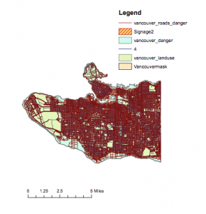
Danger Zone in Vancouver
12 percent of the city of Vancouver would be in danger if the tsunami hits. To calculate this, first I found the area of each layer: Vancouvermask_danger and Vancouvermask. To do so I found the area of the layers by creating an AREASQKM field in the attribute table, then calculating the geometry of the area in square kilometers.
Vancouvermask_danger: 15.8 sqkm
Vancouvermask: 131.0 sqkm
15.8/131= 0.120
= 12% of Vancouver in the danger zone!
Facilities Within the Zone
False Creek Residence, Villa Cathay Care Home, Broadway Pentecostal Lodge, and Yaletown House Society are the healthcare institutions that are in danger if the tsunami hits.
The educational institutions in danger are Emily Carr Institute of Art and Design, Henry Hudson Elementary, False Creek Elementary, St. Anthony of Padua, and Ecole Rose Des Vents.
To find these I used the select by attributes tool and selected healthcare and education where it intersects with Vancouver_dangerzone. I found the specific institutions by looking in the highlighted area of the healthcare attribute table, then the education attribute table.

