
GIS PROJECT: UBER HUBS PLANNING IN VANCOUVER
Disclaimer: This is an imagined scenario and we do not have any affiliation with UBER. During this project, we just imaged we are preliminary UBER Employees and our research report to UBER Vancouver.
Sadly, Uber everywhere, but not Vancouver : (
Project Files: Click links below to open
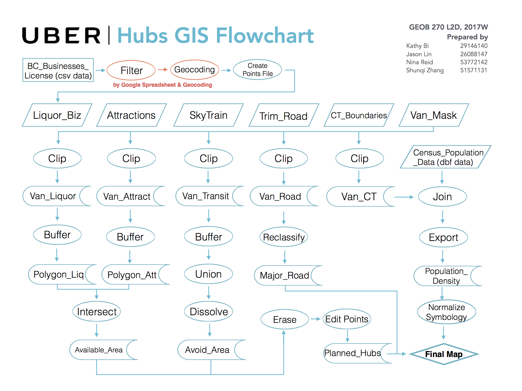
Flowchart (Also available in JPG File below)
PROJECT SUMMARY
Recent news shows that BC government has shown friendly signal to ride-share services, UBER might be able to enter Vancouver by 2018 at fastest. (Uber Vancouver: B.C. government announces support for ride-hailing services)
Our team aims to find out 15 optimum UBER Hub locations in Vancouver. Noting that UBER already has “suggested pick-up points” function that shows multiple virtual pick-up points on the phone app, we plan to design the physical UBER Hubs that serves as a big meeting points to facilitate faster and easier pick-ups in crowded areas where Address pick-ups might be not applicable due to heavy traffic and pedestrian flows. The faster pick-ups not only increases drivers’ and riders’ user experiences, but also opens up more opportunities by providing services like Free WiFi access, advertising/media, connivence shops/street vendors, newsstands, public art, drinking taps, social activities and even strangers’ icebreakers (like traffic light ping-pong games in Germany/Montreal Duracell Bus Stops). And these services not only promote the brand’s image but contribute to building the public spaces by adding spatial performance, and adds the affectivities in our hypermodern urban life, making city a more livable and vibrant place.
The project’s data is based on the activities during the daytime and nighttime.
PROJECT MANAGEMENT
Our team members collaborate and acquire preliminary data and perform GIS analysis on ArcGIS platform. All our data acquired is from Public open database and UBC GeoData server. Our team members meets on a weekly basis during the scheduled lab time to conduct the study.
THINGS LEARNED & LIMITATIONS
Initially we were planning to map the “suggested pick-up points” in Vancouver, however noting that these points are automatically generated by computer based on certain criteria, and they are everywhere too, therefore, we are unable to map these points with our current knowledge background of GIS and programming technique. Certainly there is a big leeway between our final project and our initial proposed idea.
Throughout this study we have learned a lot of interested things. Especially when we have to learn how to transform these tabular data with street address and transform them to ArcGIS compatible file. We used Google Spreadsheet’s geocoding function then created a point feature class in ArcGIS with all these Longitude and Latitude coordinates.
I was also in charge of making the flowchart during the research. Although making a flow chart ( a seemingly easy job ) is in fact a real hassle and it was time-consuming, making the flowchart allowed you to go through all the processes again and figure out the problems so my next GIS project will be far more efficient.
We also note the importance of constantly saving the data and back-up the data. Another lesson we have learned was that the GeoDatabase must be kept neat with good naming and organizations, otherwise these files with random names will make our life VERY hard.
However this study also has many limitations, we have listed details in the attached report. The two key issues are: 1. Data. There are many factors that determine the pedestrian flow, however many data is not publicly available, therefore proprietary data, and big data is quite important for a commercial company to carry out a research. 2. We are working on a manual basis, certainly I believe for this kind of topic it requires computer algorithm take all the big data in and calculate the best locations in combination with empirical information. I believe in the age of big data, the computer algorithm is able to generate a much more precise result.