Category Archives: B. LfU

LfU and Math

In what ways would you teach an LfI-based activity to explore a concept in math or science?  Draw on LfU and My World scholarship to support your pedagogical directions.  Given its social and cognitive affordances, extend the discussion by describing how the activity and roles of the teacher and students are aligned with LfU principles.


I would like to start off by saying how much I enjoyed this week, especially the working with the article Learning-for-Use: a framework for the design of technology-supported inquiry activities written by Daniel Edelson (2001).

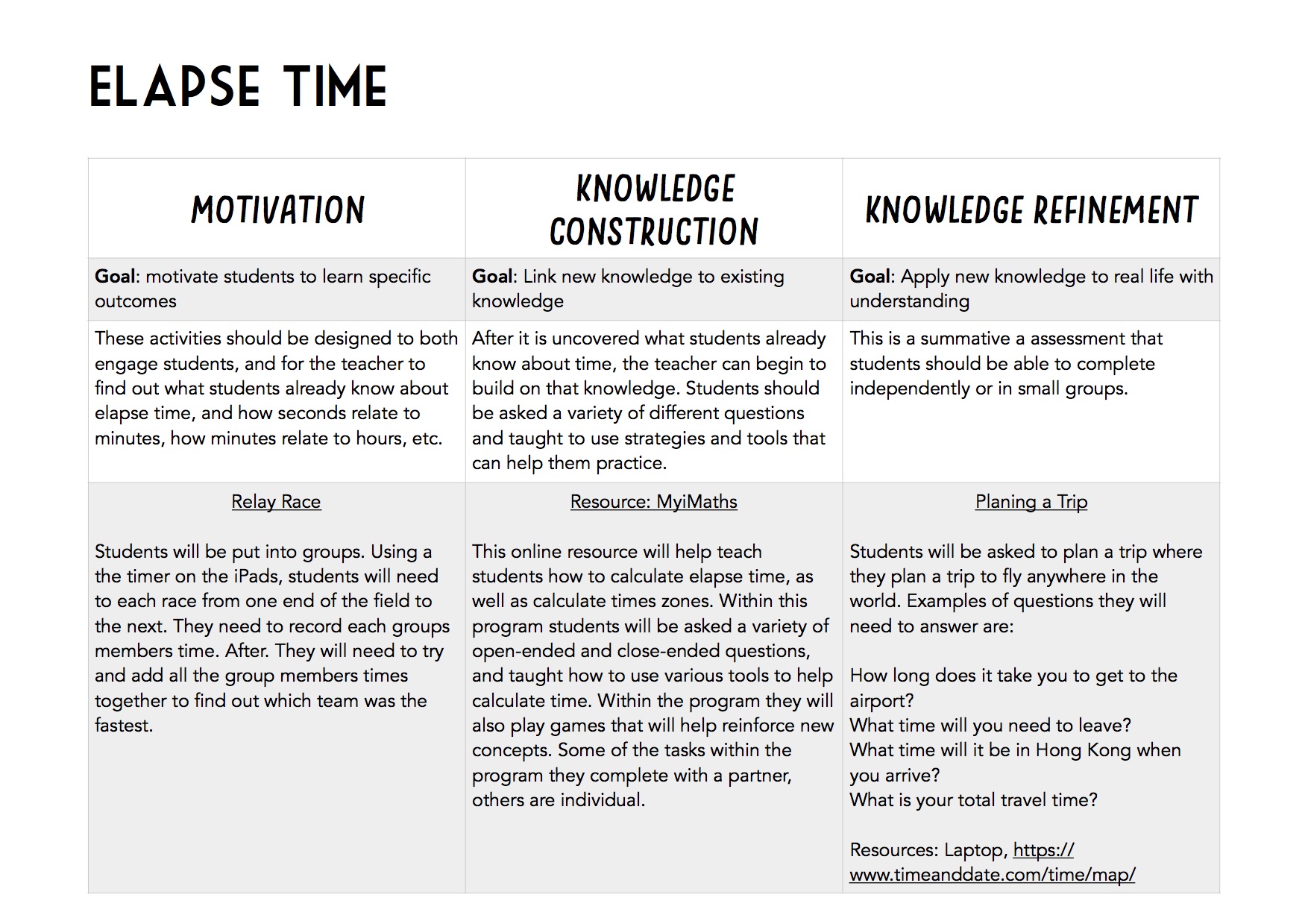
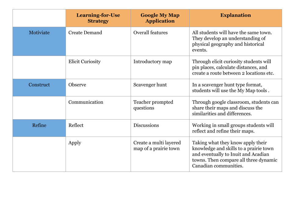
The LfU model provides students and educators with a framework with the aim of supporting deep and robust learning experiences.  The framework follows four central principles: importance of construction and modification of knowledge structures, goal-directed knowledge construction, environmental/circumstances of knowledge construction effects future retrieval, and knowledge must be constructed in a form that supports use before it can be applied.  To achieve these principles, the LfU outlines three fundamental steps toward knowledge application; motivation, knowledge construction and knowledge refinement.

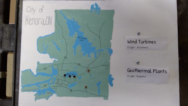
As I read through the example provided by Eldelson, The Create-a-World Project, I started creating my own project along the margins of my paper.   His paper focuses on the inquiry process in science classrooms but I wonder if I would be able to implement similar steps in math.  I wanted to focus on math because I already feel that I have been successful in integrating inquiry into my science curriculum; however, I feel that I am still struggling to provide these deep learning experiences for my students in math.  Reflecting on my own learning experiences in math, the content for this project would focus on probability in upper elementary grades.

To motivate my students and have them excited to learn about probability, I would like to begin with a card trick.  One of those card tricks that have students scratching their head, questioning how it is possible but simple enough that students would be able to figure out how it was achieved.  Without providing any answers, I would assign each students into a small group, provide each group with a deck of cards, and have them work together to recreate the trick.  As students develop their communication skills and begin the inquiry process (questioning and exploring), I would observe and find the misconceptions that my students have.  The second stage in the LfU model is knowledge construction and linking new knowledge to existing knowledge.  During this phase I would introduce my students to important terms, address the misconceptions I had observed, and we would work through the steps of probability.  Additionally, I would like to have students simultaneously adding to a thought blog as a way of incorporating technology to record students learning process.  The final step is knowledge refinement and reflection.  In this stage I would reintroduce students to the existing card trick (maybe a new one?) and have them apply the information they have learned to work through a new problem or create one of their own.

This is only the skeleton of a unit, but the readings this week are making me very excited to try it out.  Any suggestions on how to add to these ideas?  In what ways could I use more technology (or is it necessary)?


Edelson, D. (2001). Learning-for-Use: a framework for the design of technology supported inquiry activities. Journal of Research in Science Teaching, 38(3), 355-385.

Lfu-Gr. 2 Social Studies

2.1.2 – Students will investigate the physical geography of an Inuit, an Acadian, and a prairie community in Canada by exploring and reflecting the following questions for inquiry:  

  • Where are the Inuit, Acadian and prairie communities located in Canada?
  • How are the geographic regions different from where we live?
  • What are the major geographical regions, landforms and bodies of water in each community?
  • What are the main differences in climate among these communities?
  • What geographic factors determined the establishment of each community (e.g., soil, water and climate)?
  • How does the physical geography of each community shape its identity?
  • What is daily life like for children in Inuit, Acadian and prairie communities (e.g., recreation, school)?
  • How does the vastness of Canada affect how we connect to other Canadian communities?

Program of Study – LearnAlberta.ca . (2018). Learnalberta.ca. from http://www.learnalberta.ca/ProgramOfStudy.aspx?lang=en&ProgramId=564423#235575

The above Alberta Education Outcome almost seemed overwhelming when I first taught grade 2. I found this week’s reading on Edelson’s Learning-for-use technology design framework had a direct connection with my Inquiry-based unit for Canada’s Dynamic Communities. This is the first time I have seen the My World GIS program; perhaps it is due to that the program is intended for middle school through college geosciences audiences and geography courses. As an elementary,  I found the program not a viable option for my elementary students. In saying that, I have used a similar application, Google My Maps, that paralleled My World GIS program design and implementation features that made it more workable for this age group. Edelson, D.C. (2001) illustrates “Learning-for-use is a framework to support the design of learning that integrate content and process learning” (p. 381). Sadly, when I first taught this unit, I used the textbook (yes, there is a textbook for grade 2!) and we systemically went through each unit and answered the questions at the end of each unit. It was all direct instruction and not opportunities to using a GIS tool that can “effectively develop students’ spatial awareness while they” (Perkins, N.et al. 2010 p. 218) examine how living things depend on one another for survival.

Edelson, D.C. (2001) noted technology supports inquiry-based learning and Learning-for-Use. Inquiry-based learning is an approach to teaching and learning that places students’ questions, ideas, and observations at the centre of the learning experience. Educators play an active role throughout the process by establishing a culture where ideas are respectfully challenged, tested, redefined and viewed as improbable, moving children from a position of wondering to a position of enacted understanding and further questioning (Scardamalia, 2002). In other words, by using Google My Maps, students can explore the similarities and differences of the geographic areas and explore and search for data and understand how the vastness of Canada affect how we connect to other Canadian communities.

Edelson, D.C. (2001). Learning-for-use: A framework for the design of technology-supported inquiry activities. Journal of Research in Science Teaching,38(3), 355-385.

Perkins, N., Hazelton, E., Erickson, J., & Allan, W. (2010). Place-based education and geographic information systems: Enhancing the spatial awareness of middle school students in Maine. Journal of Geography, 109(5), 213-218.

Scardamalia, M. (2002). Collective cognitive responsibility for the advancement of knowledge. In B. Smith (Ed.), Liberal education in a knowledge society (pp. 67–98). Chicago, IL: Open Court.

LfU – Experiences from K to 12

In modern education, it would be difficult not to see the benefit of the LfU framework which emphasizes the need for teachers to create demand for knowledge, elicit curiosity, provide direct experiences, elicit communication, and provide opportunities to apply and reflect on their knowledge (Edelson, 2001, p. 360). Similarly, Radinsky, Oliva and Alamar (2010) support that idea that “scientists generate new knowledge through a collective, contested, negotiated process, based on communication and mutual accommodation of ideas, rather than simply through the individual exercise of abstract logical reasoning” (p. 619).

Now I could proceed with this post by suggesting hypothetical applications of the LfU framework, but I thought it would be more interesting to share some related experiences from the school I work in. Fortunately, aspects of the LfU framework are already built into our curriculum which is driven by similar core values. For instance, our Kindergarten teacher incorporated a series of critical thinking activities to help students understand food science, food waste, and business models:

Motivate – (Create Demand) JK/SK students were given the task to design their own pizzas. (Elicit Curiosity) Servery staff worked with the students to understand what goes into a pizza and how they are made.

Construct – (Direct Experience) Students created their own pizzas based on the knowledge gained from the Servery staff. (Elicit Communication) Students received feedback on their pizzas from teachers and other students for their size, shape, and choices of toppings.

Refine – (Apply) Students worked in groups to create their own pizzerias with menus / table arrangements, and executed a lunch service for staff and students. (Reflect) Food waste was weighed and students discussed changes in the pizzas/menus/service to reduce waste in the future.

In Senior School, application of an LfU-type framework has naturally been more complex. In some cases, they have been augmented by partnerships with other educational organizations.

Motivate – (Create Demand) As part of an interdisciplinary course, groups of students were challenged by the U of T, Munk School of Global Affairs to develop a technological solution for the world birth registry crisis. (Elicit Curiosity) Each group studied the issue in different countries and decided on one country to develop a solution.

Construct – (Direct Experience) One particular group explored different technology-based solutions including developing a Smartphone app. (Elicit Communication) The group consulted with various experts, government officials, and technology companies within the country.

Refined – (Reflect) Due to the country’s emerging infrastructure, the group developed a solution that incorporated a text-messaging system that was more cost effective and easier to implement. (Apply) The group presented the solution first to a panel of local experts and then communicated it to leaders in the target country. That country is now implementing a system based on the group’s solution.

I believe the power of this LfU framework is fully realized when motivation is situated in a challenge that is real to the student(s) and ideally has no solution. This can be frightening for teachers as they usually present concepts knowing the answers already. I would love to hear your thoughts on these experiences and whether they exemplify the LfU framework.

Edelson, D.C. (2001). Learning-for-use: A framework for the design of technology-supported inquiry activities. Journal of Research in Science Teaching,38(3), 355-385.

Radinsky, J., Oliva, S., & Alamar, K. (2009). Camila, the earth, and the sun: Constructing an idea as shared intellectual property. Journal of Research in Science Teaching, 47(6), 619-642


Learning For Use – Earthquakes

  • Imagine how LfU principles might be applied to a topic you teach. Now switch out the My World technology. What other domain specific (and non-domain specific) software might help you achieve these principles while teaching this topic? By domain-specific, we mean software designed for STEM education, and by non-domain specific, we mean software or other forms of technology that could be used generally in multiple domains (eg. Wikis). Other GIS software can be selected for the switch.

Learning for Use (LFU) is a constructive teaching pedagogy that emphasize on constructing and refining relationships between abstract concepts. Distinct from other learning approaches, LFU includes ways in which people can support social emotional states when learning (i.e. motivation). This learning model strives to decrease misconceptions by refining conceptual relationships. Another definitive feature of LFU is that learners must apply their knowledge. More specifically, “learning how to use conceptual knowledge must be part of the learning process, if the knowledge is to be useful.” (Edelson, 2001, p.357) Uniquely, LFU theorists suggests that although this model is relatively linear, it also synergistic in a sense that as students work through their inquiries, they are more motivated to learn. Their reflection also promotes opportunities to expose learning gaps, hence, motivating them to learn.


Design

Instead of My World, this design employs a collection of educational tools to support understanding of earthquake’s epicenter and magnitude. Designed for students grade 6 or higher, learners work through labs to understand how to use data from seismograms to determine the location of the epicenter of an earthquake.

Motivating learners

Edelson (2001) supports that students have to become aware of their own learning gaps and should be motivated fill in these knowledge gaps. Here, it activates students’ prior knowledge of earthquakes and exposes misconceptions.

Students are given seismograms to observe and consider. Students design a map as a response to the following scenario: If an earthquake magnitude of 5.0 happened in downtown Vancouver, locate safe areas for emergency responders build an earthquake refuge. Using the earthquake simulator, compare student created maps and actual map. Students redraw new locations for possible areas of safe refuge.

Knowledge Construction

Edelson (2001) claims that an important part of this stage is to allow students to investigate and observe information by using simulations to further decipher the relationships between variables.

In pairs, watch through Virtual Reality Earthquake Simulation (i.e. Pai-away) to develop basic knowledge about earthquakes. Learners also work through a Gizmos lab (i.e. Earthquake 1) to supplement their understanding about seismographs. Students work through the activities guideline to learn strategies to study about the relationship between incoming signals, time difference and distance. Engage in whole class discussion about factors that contributes to an earthquake and signs about the distance from the epicenter.

Knowledge Refinement

Reflection and application are two key features of this part of the learning (Edelson, 2001). Students have to critically analyze information and use observations to support their claim about the relationship between concepts.

Students work through an additional Gizmos lab (i.e. Earthquake 2) to learn about using seismographs to determine the epicenter. Students screenshot their findings and publically share strategies of finding the epicenter of the earthquake.

Knowledge Application

In order to make conceptual relationships between variables more memorable, students has to demonstrate that they can apply their knowledge.

In a small group design data for a hypothetic earthquake and provide graphs and corresponding map to show the epicenter of an earthquake and locations of possible earthquake refuges.

LFU & Big Data

Interestingly, there is a connection between LFU and big data. In essence, My World and other GIS software are databases with inquiry tools. Notably in WISE and LFU, students are asked to analyze information available in a database. They conduct experiments to collect and analyze data. Research in big data inquiring about drug discovery and databases suggests that these tools facilitates collaboration and allows users to use one simple interface to generate hypotheses and possible novel solutions (Ekins, Clark, Swamidass, Litterman & Williams, 2014). Hence, using inquiry methods, these learning spaces allow students to collaboratively learn about a topic.

The Future of LFU

Using Jonassen, Carr & Yueh’s (1998) idea of technology as tools to share cognitive load, imagine the future of LFU. With applications like Science Journal, with a phone’s sensors, users are able to easily collect local data for experiments. This provides hopeful outlook on independent experimentation. Students are no longer reliant on access to collaborative databases. Rather, they can easily and systematically peruse scientific inquiry by using technological tools to generate data, document and annotate findings.

Discussion Directions

Consider the use of Pai-Away VR simulation in this design. How can VR support LFU?

LFU is designed to help learners to become a data analyst. Agree or disagree. Why?

Reference

Edelson, D.C. (2001). Learning-for-use: A framework for the design of technology-supported inquiry activities. Journal of Research in Science Teaching,38(3), 355-385.

Ekins, S., Clark, A. M., Swamidass, S. J., Litterman, N., & Williams, A. J. (2014). Bigger data, collaborative tools and the future of predictive drug discovery. Journal of computer-aided molecular design28(10), 997-1008.

Gizmos Labs https://www.explorelearning.com/  

Jonassen, D.H., Carr, C. and Yueh, H.P. (1998) Computers as mind tools for engaging learners in critical thinking. TechTrends, 43, 24-32. http://dx.doi.org/10.1007/BF02818172

Multi-narrative Scavenger Hunt with LfU

As you probably know by now, I am not a math or science teacher, but rather, an ELA teacher. However, as I was reading through the LfU materials and exploring the GIS tools, I was struck by how easy it would be to use these sorts of resources, and of course, the framework, in designing and enhancing a lesson for my Creative Writing classroom.

For example, in LfU, each lesson follows the path of 1) motivation, 2) knowledge construction, and 3) knowledge refinement (Edelson, 2001). To further detail this process, there is 1) create demand, 2) elicit curiosity, 3) Observe, 4) Communicate, 5) Reflect, and 6) apply (Edelson, 2001). Using this more detailed look at LfU, an idea for an enhancement of a writing project quickly came to mind.


Motivation

The students could be informed that they are going to be writing a narrative story of a group of people in a race to get a cash prize (think Rat Race style). A sample type scavenger hunt could be made that would utilize the classroom or even the school campus. After students engage in the hunt, they could reflect on what kinds of things helped their team, and what kinds of things hindered them.


Elicit Curiosity

Perkins et al. (2010) noted that students need to develop more and more their special literacy. This writing project would use the tool of Google Map to help them not only improve their special literacy, but also bring an element of reality and logistical thinking to their writing. Each student would be given a certain amount of “money” and told that this is what their character would have at their disposal to make it across the country and get the cash prize. It would be up to them to budget and plan the trip using Google Maps and online information about fuel efficiency and other modes of transportation. The person whose character was able to make it to the prize (while still weaving these elements into their story and making it entertaining) would win the prize. Also, the clues that they found on the initial scavenger hunt would also contain special bonuses that were hidden on the map, using the MyMap function on Google Maps. When they would locate one of these “power-ups,” they would find a word that would give them bonus time or money.


Observe

Google Maps is a tool that most adults today use on a regular basis. It has powerful, up to date information not just about directions, but also traffic and alternate paths. There was a time that GIS were difficult to navigate and not readily accessible (Perkins et al. 2010), but those days are long gone. Students can quickly and easily access the GIS through their 1 to 1 Chromebooks and begin to actively participate in the process of plotting a path, using time, distance, money, accommodations, and modes of transportation. All of this information would be logged in a timeline.


Communicate

All of the students’ findings would be compiled together in a first-person narrative of a person involved in the race for the prize. Through the process of writing, they would be able to not only bring the information alive but also make their character come to life as they use what they find. All of the stories would be compiled together in a single book and the time, money, and distance traveled would be recorded, as well as a map of their journey.


Reflect

By reading through and discussing other people’s stories, students would have a chance to reflect on the decisions that they made and the process that they used to get there. They will have the chance to learn better methods from their classmates and adapt their method for the next time.


Apply

The applications for this are numerous, but the most obvious would be in trip planning. By thinking through the money, time, paths, food, fuel, accommodations, etc that are necessary for a road trip, students will have a better appreciate not only for the planning on trip, but also spacial awareness and narrative writing.


Sources:

Edelson, D.C. (2001). Learning-for-use: A framework for the design of technology-supported inquiry activities. Journal of Research in Science Teaching,38(3), 355-385. http://ezproxy.library.ubc.ca/login?url=http://dx.doi.org/ 10.1002/1098-2736(200103)38:3<355::aid-tea1010>3.0.CO;2-M


Perkins, N., Hazelton, E., Erickson, J., & Allan, W. (2010). Place-based education and geographic information systems: Enhancing the spatial awareness of middle school students in Maine. Journal of Geography, 109(5), 213-218. http://ezproxy.library.ubc.ca/login?url=http://dx.doi.org.ezproxy.library.ubc.ca/10.1080/00221341.2010.501457

LfU – it’s good for you.

Last year, as a culminating activity for the grade 9 electricity unit, I co-designed a project on energy sources.  Students chose a city (from a given list) somewhere in Canada and were tasked with creating a plan to supply it with electricity.  They needed to research the benefits and disadvantages of each type of power plant, decide which were most appropriate for their location, and do a cost analysis indicating how they could supply the energy under the one-time building and monthly costs budgets.  GoogleEarth was used to search each location for geographical features that could be used for power generation.  The final product was a constructed scale map on press board (we used GoogleEarth to help) showing the types and locations of the various plants they chose to power their city, using different coloured lights connected to switches using parallel and series circuits.  Their choices needed to be connected to a legend on the map, meet the power demand and budgets, and be justified with written explanations.

The use of ArcGIS would give further options to this project – students could do an analysis of what type, how many, and where Canada has power plants, and which types of power generation should be expanded further.  Population data can be analysed to see which plants could be used to meet the needs of the region.

I believe this project could fit the LfU model.  This model consists of a 3 step process including motivation, knowledge construction and knowledge refinement (Edelson, 2001).  Edelson sees motivation as being caused by a need for new knowledge – a limitation or gap of the learner’s prior knowledge.  This project helps students to recognize that they need more information – about the city, the energy sources, and the financial costs.  Motivation can be separated into demand and curiosity, (Edelson, 2001), where a need for more information drives the desire to find out more.

Through this project, knowledge is co-constructed as the students research information, and incrementally build their knowledge on power generation and their locations.  Edelson, 2001, divides this step into observations and communication.  Communication is seen when students discuss the pros and cons together and work to develop a consensus of ideas and priorities.  I think observation could be expanded by using ArcGIS to determine current plant usage and populations as discussed above.

The third step of LfU is knowledge refinement which Edelson breaks into reflection and application.  Reflection is seen when students go back over their learned information to assess what their priorities are, and if they meet the stated parameters.  Application is covered by the project being imbedded in a real-world context, where students need to determine the best approach for that region or city.  Radinsky et al emphasize this as well, stating students need to be immersed in the “context of the complex, messy world of actual data”, (2006).

I could also make this project more inquiry based by assessing prior knowledge – asking students to make predictions about which type of power plant is most common, cheapest, or most efficient – to rouse their curiosity.  Additionally, starting with cities with known parameters, will allow students to assess the effectiveness of the current energy plan and energy sources and make comparisons with other cities in the region using ArcGIS.  Collected data and research information could be stored using portfolio-type software such as Progress Portfolio, discussed by Edelson (2001).

Radinsky et al (2006) researched the effectiveness of different assessment strategies.  I did already have a unit test on the material as well as the submitted project, but I think it would be good to add presentation and interview components.  There is great value in using triangulation of assessment to gain a clearer picture of understandings: “Each assessment allowed a somewhat difference glimpse into what students understood and how they understood it and could apply it. The system of assessments provided a more nuanced view of students’ understanding than what would have been possible with only one or two of these”, (Radinsky et al, 2006).  A presentation component enables students to share their ideas and justify their solutions to an audience, while providing evidence of what the group had constructed as a whole, and also some of the understandings of individual group members.  Finally, I would add an individual interview component.  The interview would consist of a series of structured questions to prevent leading questions or a giving away of the answers, and to allow opportunity for spontaneous sharing of understandings.  According to Radinsky, (2006), interviews are the best way of eliciting partial understandings, and this process often yields rich information about what students know.  Using a variety of assessment methods would give a better picture of students’ overall understandings.

  • Edelson, D.C. (2001). Learning-for-use: A framework for the design of technology-supported inquiry activities. Journal of Research in Science Teaching,38(3), 355-385.
  • Radinsky, J., Sacay, R., Singer, M., Oliva, S., Allende-Pellot, F., & Liceaga, I. (2006, April). Emerging conceptual understandings in GIS investigations. Paper about forms of assessment presented at the American Educational Research Association Conference, San Francisco, CA. Available from Google Scholar.


Lfu to reduce our carbon footprint

First, I have to say that the resources that we were introduced to and explored further were a bit overwhelming (MyWorld GIS, WorldWatcher, ArcGis, and Google Earth). I say “introduced to” because many of them were new to me and I was shocked that I had not heard of most of these as some of them are great for getting students excited and motivated about what they are learning in the classroom. The only program that I had any knowledge or experience with was Google Earth. I however, have only explored it at a very basic level with my students. One of my goals this year, is to try and find ways to connect what my students are learning to real life situations or experiences. Far too often, our students are learning different concepts and they don’t understand how it was important to their life or when they would ever use it again. I definitely will need more time to explore these applications and programs, but this week was a great start to get me thinking about how I can integrate them into my grade 7 class.

“The Learning-for-Use [Lfu] model is a description of the learning process that can be used to support the design of content-intensive, inquiry-based science learning activities” (Edelson, 2001, p. 355). The new BC curriculum encourages teachers to move away from the focus being on reciting and memorizing, but rather focus on a deeper conceptual understanding. This can be done by providing students with opportunities to communicate, collaborate, critical think, question, ponder, infer and make predictions. Lfu is based on a three-step process that includes motivation, knowledge construction, and knowledge refinement. Students are motivated when they find the concepts/activities relevant and interesting. As they are “constructing knowledge,” students are guided by the questions that interest them or that they wonder about. These questions/wonders can be discovered by having them complete a KWL chart or allowing them to brainstorm in small groups or partners. I often do a “pair-share” activity to get students thinking and collaborating on a new topic. Finally during the “knowledge refinement” stage students should be provided with lots of time to reflect upon their learning and apply their understanding to real life situations or scenarios (Edelson, 2001).

Since, I am teaching grade 7 this year, I wanted to explore a topic in the science curriculum. The topics include evolution, chemistry, electromagnetic forces and climate change. One area that I was interested in exploring a little further (as it is a unit that I am currently developing) is climate change. We will be starting an earth challenge in April and May, and the four main topics we will be covering are water-wise, waste-wise, invasive species and air quality. At the end of the month, we will be having a “challenge” game with the other grade 7 classes. Each team of students will be asked questions on these different topics in a Jeopardy style game setting.  

As an introductory activity (and to get students motivated), I would have the students brainstorm what they already know about Climate Change (if anything). I have a range of students in my class, so I would most likely have students work in random groupings of 3-4 students and have one student record all of the ideas. This way students would all be able to participate, regardless of whether or not they can write down the ideas (I have a few students with written-output issues). This activity would guide my future lessons. If students have very little knowledge of what climate change is, we would participate in some introductory activities. Nasa has some great activities, including fun facts, videos and interactive activities to get students’ excited and to give students a basic understand of what climate change is (https://climate.nasa.gov/). There are quick one minute videos on a variety of topics to pique students’ interest (Greenland Ice, Sea-Level Rise, etc.), as well as some quizzes and 3D virtual videos. Once students were given some time to explore this site, I would let them break into groups to discuss what they found interesting, what they still had questions about or didn’t understand. and what they wanted to explore more about.

The next activity (I found on the ArcGIS website) is about climate change and how it has affected temperature. It is a geoinquiry map investigating regional patterns to changes in temperatures. Students are able to explore different parts of the world to see how temperatures have changed from year to year. This would lead into an activity that has the students choose a city (could be any place in the world) and month of the year. They would create a graph (math connection) of how the temperature or precipitation has varied from year to year. Another map that I found on ArcGIS is called “Climate Change Stress Index” and it focuses on the degree of change in temperature, precipitation, vegetation and habitat between history and the (projected) future. Depending on time (and student interest), I might have students explore only one or two of these topics.

Once my students have a basic understanding and are excited (that’s my goal!) about climate change, they will choose a topic (water or waste-wise, air quality or invasive species) that interests them and form small groups. The students will be allowed to present the information that they discover in anyway they choose (poster, PowerPoint, Google Slides, etc.). This allows students to be as creative as they want. To help students refine their knowledge, they will be given opportunities to think about what changes in their life they can make in order for them to reduce their carbon footprint. Another possibility is for the students to implement a program at the school to help with the climate change issue (school community garden, composting, etc.). Much of this last part will be determined with student input.

Edelson, D.C. (2001). Learning-for-use: A framework for the design of technology-supported inquiry activities. Journal of Research in Science Teaching,38(3), 355-385.

Let’s stop “doing science”!

  • In what ways would you teach an LfU-based activity to explore a concept in math or science? Draw on LfU and My World scholarship to support your pedagogical directions. Given its social and cognitive affordances, extend the discussion by describing how the activity and roles of the teacher and students are aligned with LfU principles.

One of the resources that I had recently come across, with the help of a classmate in this class, was also mentioned in lesson 3 on canvas, realworldmath.org. It is a great resource to take learning outside of the classroom and falls right in line with Lfu principles. This website provides certain lessons and activities to help with the delivery of content and is embedded with inquiry in it. I would use the lesson on Measurements for grade 8 students to understand Surface area unit of their curriculum.

This lesson on Measurements on realworldmath.org fulfils the three steps of Lfu model listed by Edelson in her article. “The goal of the Lfu model is to overcome the inert knowledge problem by describing how learning activities can foster useful conceptual understanding that will be available to the learner when it is relevant” (Edelson, 2001, pg. 356). This lesson on Measurements, along with the other lessons on realworldmath.org, help students overcome the inert knowledge problem by creating an atmosphere for students to see how useful this learning can be. First step that is described in Edelson’s article is to motivate. Using the lesson on Measurements- first example of complex area will motivate my students to ask themselves, what would the surface area of a complex area like this would look like. My students will be curious about finding area of surfaces that are not just one shape (a square, rectangle, triangle) but a combination of shapes. My students will only have knowledge of how to find surface area of basic shapes before looking at this problem. At this point, students will be asked to observe and try to see if it is possible to find area of a surface that is not explicit ally a shape that they can name. This will fall under the second step of Lfu of constructing knowledge. After this inquiry-based task, students will receive direct communication to help them reach the solution; where the students who did not figure out on their will be assisted with realizing that it is a combination of squares and rectangles. The third step of Lfu says that students should be able to apply their knowledge, which students will do at this point and divide this shape into squares and rectangles and find the surface area for themselves. Students will be asked to reflect on this problem in the end where students will be expected to have understood that the area of a surface can be determined if the surface can be divided into shapes that we know of.

“If we conceive of both science and learning as social endeavors with shared intellectual ownership, how should we assess students’ progress toward “thinking like scientists”, or “doing science”? (Radinsky, Oliva, & Alamar, 2010, pg. 620). This quote triggered a memory in my memory-lane where I was observing an elementary school teacher before doing my teaching degree to get some volunteer hours in a classroom. She was a great teacher with great teaching techniques but I still remember her using the words, “put your math away now, we are going to ‘do science’ now”. I remember these words did not settle well with me back then but I did not know what was so wrong with saying “do science now”. “In traditional science classrooms, content and inquiry skills are taught separately through separate learning activities” (Edelson, 2001, pg. 356).

Edelson did an amazing job at defending today’s science teachers feeling torn apart with the amount of pressure put on them from the administration to incorporate technology and inquiry while delivering a high density of content in a classroom; and all of that without any real support to help teachers achieve all of this. Edelson makes a great point by noting that traditional science teachers think that content and inquiry skills must be taught separately, which is why they would refer to “thinking like scientists” as “doing science”, in my opinion. ‘Doing science’ indicates that a student must ‘do science’ for the given period of time and then forget about it once they leave the classroom, leave the learning behind because that is where they ‘do science’. On the contrary, when the students are motivated to “think like scientists”, they are forced to take that with them outside of classroom because it becomes a part of their thinking process. We need our students to take learning outside of the classroom, virtually and physically. Lfu is a great teaching framework that provides us with tools that can help teachers encourage students to take their learning outside of the classroom.

Edelson, D.C. (2001). Learning-for-use: A framework for the design of technology-supported inquiry activities. Journal of Research in Science Teaching,38(3), 355-385

Radinsky, J., Oliva, S., & Alamar, K. (2009). Camila, the earth, and the sun: Constructing an idea as shared intellectual property. Journal of Research in Science Teaching, 47(6), 619-642.

LfU to enhance cross curricular learning

In what ways would you teach an LfU-based activity to explore a concept in math or science? Draw on LfU and My World scholarship to support your pedagogical directions. Given its social and cognitive affordances, extend the discussion by describing how the activity and roles of the teacher and students are aligned with LfU principles.

I was intrigued when reading about the Learning for Use (LfU) model. It seems so straight-forward – but why haven’t I used it or heard of it before? Its aim is to think about the design of activities to stimulate and encourage “robust, useful understanding” (Edelson, 2011, p. 359). When following the three phase design process, the students understanding should develop at a deeper level. The Create-a-World project modelled the LfU design theories soundly and the project was engaging for middle school science students. I appreciated Edelson’s comparison of content-focused motivation versus achievement-based motivation (p. 373) and that it seemed to shed light on my initial question. Not all students are motivated by achievement but often the way our curriculum and exam processes are organized imply that they are. Having students engage more deeply with cross-curricular content is something that I had in mind when I designed a concept to explore through LfU.

For this post, I decided to look at combining the topics of math and geography for my grade 6 students by exploring both eco-friendly houses and area and perimeter. I found the provided Learning for Use framework to be very helpful in creating this. Further, after exploring the Google earth software, I believe that this can be a helpful tool to delve deeper into these topics. I based my plan off the table provided in Daniel Edelson’s (2001) work (p. 360).

Motivate

Create a demand for the new knowledge and elicit curiosity

We will start by looking at our own houses and investigating footprint of our house. Initially, this has to do with the size and the shapes of rooms. The students will come to school with measurements and we will then be able to make some calculations – for example, calculate the perimeter of their yard and the area of rooms inside their own houses. The teacher can use their own house to model this activity. The student will then use Google Earth to locate our own houses in Manchester and use the function of Street View to explore our own communities in more depth. To develop the idea of our own house’s ecological footprint even further, we will explore what types of energy we consume in our houses. They will need to discuss this with the guardians in their household. We would then discuss and research, how could we build a more eco-friendly house?

Construct

Provide learners with the direct experience and facilitate communication

Thinking about size of house and more sustainable energy choices, children will work together to design an eco-friendly house. This will draw on their knowledge of area and perimeter, as well as on our geographical knowledge of renewable energy sources. This phase to be initially created with pencil and paper, allowing students to be creative and get all their ideas out. This allows learners of all levels to work to their own abilities. Students communicate with each other and teachers to support and scaffold as needed.

Refine

Learners apply knowledge and reflect upon learning experience

Students will then use Google earth to decide where they might build their house – can they find a spot that will be most suitable? What climate are they looking for?  It would be great if they could use an online tool to display their plan. I’ve had a search but nothing has stuck out to me. Does anyone have any ideas of what app or website would work in this instance?

This cross-curricular project would help students to apply the knowledge of area and perimeter in a more hands-on way. Further, it will help them to think about energy sources in a more applicable way. It involves problem solving and having to apply their knowledge in new ways. This plan also creates more ecological aware citizens for the future. We would reflect on what concepts we could take from our designed houses and apply to our real lives to become more ecologically aware citizens.

I think that this approach would engage the students and that they would enjoy using Google maps and Google earth. I was interested to read Kulo and Bodzin’s (2011) analysis of their study on eighth grade classes using geospatial technologies in their energy unit. The authors found that using the geospatial technologies received both positive and negative reactions from the students. They found that some students, after initial excitement, found the tasks too repetitive if using the same program day after day. This speaks to me directly as I think that, as with many theories and tools within education, balance and variety are ultimate necessities.


References

Bodzin, A. M., Anastasio, D., & Kulo, V. (2011). Integrating geospatial technologies in an energy unit. Journal of Geography, 110(6), 239-251.

Bodzin, A. M., Anastasio, D., & Kulo, V. (2014). Designing google earth activities for learning Earth and environmental science. Teaching science and investigating environmental issues with geospatial technology, 22(1), 25-36.

Edelson, D.C. (2001). Learning-for-use: A framework for the design of technology-supported inquiry activities. Journal of Research in Science Teaching, 38(3), 355-385.

Time with LfU

I really appreciate the features of the LfU framework. LfU is a model that teachers at any level can adapt and work onto an inquiry enriched context. One aspect I think all teachers would enjoy is that it is broken up into three sections. You often see frameworks and models that are multilayered, but LfU managed to embed and include essential features of multiple teaching and learning theories into three parts which makes it a manageable user-friendly model. By adopting this type of framework, teachers can ensure that students aren’t merely memorizing facts but instead building knowledge through activities that foster conceptual understandings. Learners can then apply what they are learning in their real life (Edelson, 2000). Furthermore, the framework also lends itself nicely to technology integration. By adding this layer allows learners to work on their spatial literacy. The advantage to this is that students will be able to “manage, visualize, and interpret information” which Perkins et al. (2010) describe as something that will be necessary for employees in our future workforce.

One concept that my Grade three students often struggle with is the concept of time and specifically elapsed time. Time is one of shape and space outcomes that I see as being one that is most applicable to real life, but often not a lot of time (ironically) is spent on it in school. This is why I chose this outcome. Below is a table that I created and included an activity for each section of the LfU model. One crucial aspect that is not on this table is ‘reflection.’ While I haven’t covered it here, I think it is one that is of utmost importance in any subject. One activity I might have my students do is repeat the motivation activity and have them reflect on how their knowledge improved and what strategies and tools they used the first time and what ones they used the second time.


Edelson, D.C. (2001). Learning-for-use: A framework for the design of technology-supported inquiry activities. Journal of Research in Science Teaching,38(3), 355-385

Perkins, N., Hazelton, E., Erickson, J., & Allan, W. (2010). Place-based education and geographic information systems: Enhancing the spatial awareness of middle school students in Maine. Journal of Geography, 109(5), 213-218.