Trans Mountain Expansion (Programs) Student
September 2020 – December 2020
Reflective Analysis of Learning in my Third Co-op Work Term at Transport Canada
For my third co-op term at Transport Canada (TC), I had a huge opportunity to shift my work from the Corporate Services branch over to the Programs branch, which falls more closely in line with my field of study. In Programs, I provided support to managers and colleagues, and assisted on a wide range of projects as part of the TC Pacific Regional Secretariat supporting the implementation of initiatives related to the Trans Mountain Expansion (TMX) Project. These initiatives include 8 accommodation measures and 16 Canadian Energy Regulators’ (CER) recommendations. Transport Canada leads 3 of the 8 accommodation measures, with those being the Enhanced Maritime Situational Awareness (EMSA) initiative, the Marine Safety Equipment and Training (MSET) initiative, and the Quiet Vessel Initiative (QVI). My main responsibilities as a co-op student included managing the TC TMX General Inbox, along with creating a comprehensive spreadsheet in Excel to record and track all engagement with the TC led and implicated accommodation measures and recommendations. I also provided support on internal and external inquiries from other departments, stakeholders, and Indigenous communities, as well as working on a variety of projects, which you can find listed in more details below.
Projects
Phase IV Engagement Tracker
The biggest project I worked on during my co-op term was the TC TMX Phase IV Engagement Tracker, in which I created a comprehensive 17 tab Excel spreadsheet to monitor, record, and track all engagement with Indigenous communities on the TMX accommodations and recommendations. The purpose of the spreadsheet was to streamline inquiries for updates on engagement for each measure and recommendation, as well as to keep all records organized. The document was made for internal use at Transport Canada, and to make the document more user friendly, I worked in coding so that the document would open on the table of contents each time it was opened, which provided links to each of the tabs on the spreadsheet. Throughout the term I contentiously worked on improving the spreadsheet to store additional information that included contacts, resources, and links to other documents. Mid way through the term, I provided a presentation to the TC TMX Phase IV Working Group so that others would be able to access the information for their usage. At the end of the term, I trained the next employee on how to update and use the spreadsheet for continuous record keeping.
Micro Mission: The Impact of Covid-19 on the Mental Health of Public Service Employees
Midway through my co-op, I participated in a 6-week part time micro mission to assist in data collection, analysis and the presentation for a pacific region pulse survey. During the micro mission, I helped conduct quantitative analysis and create infographics on the results of a mental health survey to assess the well-being of Public Service employees during the Covid-19 pandemic. There were three of us who worked on the quantitative aspect of the survey, and I assisted our team by creating a PowerPoint of infographics that were visually pleasing and easy to interpret. The infographics were then presented to the BC Federal Council committee, who will assess and discuss what the next steps will be to provide better support and assist employees with their well-being and mental health during the ongoing pandemic.
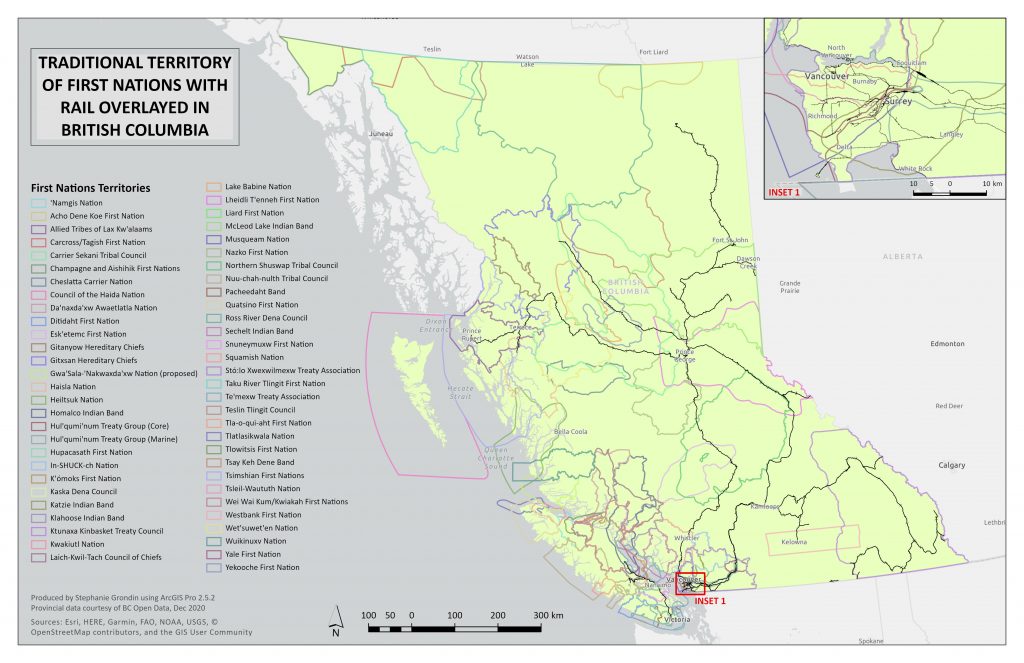
Maps: The Intersect of Railways and Indigenous Territories in British Columbia
During the last month of my co-op term, I assisted my manager in creating 8 maps using ArcGIS Pro, which focused on railways that intersected with Indigenous communities, territories, and reserves in British Columbia. A sample of the first map is provided below, which gives an overview to the complexity of overlapping Indigenous territories in British Columbia. The black line represents railways that cross into numerous Indigenous territories, with a closer look of the Lower Mainland in the inset. I also worked on 5 other maps, which zooms into sections of BC (ie. Northern, Southern Interior, Fraser Canyon, Lower Mainland, and Vancouver Island) and provides a spatial analysts of railways (with a 5km buffer) that intersect and cross through Indigenous territories. The last 2 maps I created provided an overview of Indigenous communities that fall within 5km of rail in BC, and also railways that pass through Modern Treaties in BC. All data was provided from BC Open Source data catalogue.