Water Chain Assessment:
The main component of this will be a “water chain” assessment of Surrey’s water system. A water chain assessment is a simple method that categorizes a water system into its upstream and downstream components [2]. Upstream components are characterized as the primary, freshwater water resources that enter the regional water system and have not yet been used or altered in any way. As these upstream resources are transformed, moved, and used in different ways, they become classified as downstream components. Within the water chain assessment, each component is connected in a step-by-step fashion by the processes that affect how the water moves and is altered in terms of quality and quantity, and the pathways that show the direction of where the water flows (figure 1).
Figure1: The water chain framework. As water resources enter a water system as an input, they are classified as upstream resources. As they move through the water system and are affected by different processes (for example: infiltration, surface runoff, drainage, detention, etc.), the properties of the resource may change. Throughout the water system, each water resource may be used to achieve any variety of water system goals, (for example: recreation, agricultural production, aquatic habitat, etc.). An arbitrary water system boundary may be delineated whatever scale is appropriate for the subject of the assessment.
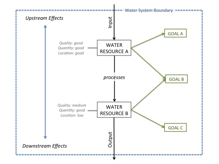
In this way, a water chain is a useful tool for creating simplified representations of how water moves through time and space, and can be used to assess how well an overall water system is functioning. When resources of any kind become unavailable or scarce, there are three possible courses of action:
- Improve the efficiency of how the resource is used,
- Find a new source of the resource, or
- Reduce losses of the resource from the system.
By breaking a water system into a simple step-by-step flow, a water chain assessment can precisely identify where these inefficiencies, opportunities, and vulnerabilities exist within the water system. Consequently water managers can use it to target specific pathways or processes for improvement or remediation, in order to achieve a variety of goals and to integrate upstream and downstream issues.
Suitability Assessment:
Once the water chain analysis illustrates how water flows through time and space in space in Surrey, a “suitability assessment” can be conducted for each water resource. The focus of the suitability assessment in this project is agricultural production; however different combinations of parameters may be used to determine the suitability of each water resource for different purposes. This water suitability assessment for agriculture will include the following 5 parameters:
- What is the location of the water resource? (e. What is the geographical proximity of the water resource to agricultural land?)
- What is the quality of the water resource? (e. Are there any pathogens, contaminants, metals, or physical properties of the water that make it unsuitable for some forms of agriculture?)
- What is the quantity of the water resource? (e. Is it available in sufficient supply to support a cropping system?)
- What is the timing of availability of the water resource? (i.e. Is it available at reliable timing throughout the growing season?)
- Who has jurisdictional claim over this water resource? (i.e. Can it be legally be acquired and used by the city of Surrey or its residents?)
The information gained from the resource suitability assessment and flow pathway information provided by the water chain analysis can then be combined to identify new opportunities for agricultural production in Surrey.
Surrey’s Water System:
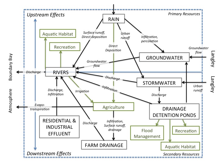
Surrey’s water system (figure 2) is composed of 3 main primary resources: rain, groundwater, and the three rivers; that flow into 3 main secondary resources: stormwater runoff, drainage detention ponds, and diked farm drainage. The system boundary for this assessment is aligned with Surrey’s municipal boundary for the purpose of focusing on the water resources and flow processes over which Surrey has jurisdictional power; however, it should be noted that several of the resources cross beyond these jurisdictional boundaries. Several groundwater aquifers lie between the borders of Surrey and Langley; stormwater runoff flows from Surrey from the highly urbanized city of Langley; and Surrey’s three rivers flow into Boundary Bay. At this time, the Surrey’s water resources work to achieve three goals: to enhance agricultural productivity; to create recreation opportunities for Surrey residents, and to provide environmental services such as aquatic and wildlife habitat.
It should be noted that domestic waste exists in an entirely segregated flow pathway in Surrey, and therefore is not included in this water system assessment. Surrey’s domestic water supply originates from the watersheds in North Vancouver, and the consequent grey and black water from domestic use exit the system as sewage, and are transported to the wastewater treatment facility at Annacis Island.
Figure 2: Surrey’s water system.
Water Chain & Suitability assessments:
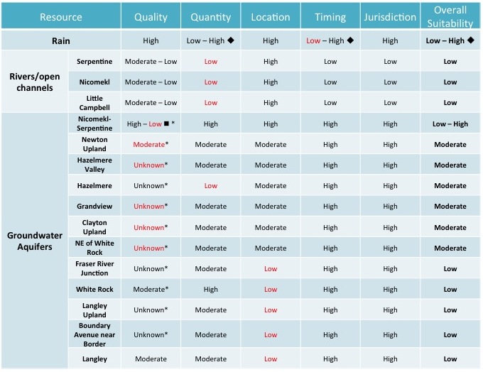
The resources are ranked on a scale from “none/unknown – low – moderate – high.”
Rivers: Low potential for agricultural production
Current Functions: agriculture; recreation; wildlife and aquatic habitat
The primary output of Surrey’s three rivers is to provide water for agricultural production; however they also provide other outputs in the form of recreational benefits and wildlife habitat. For agricultural purposes, all three rivers provide water for irrigation and livestock watering. They provide recreation opportunities in the form of fishing, boating, and parkland; and the Campbell River also has two locations at which swimming is available. All three rivers provide aquatic habitat and spawning grounds for threatened species of Coho and chum salmon [3] and cutthroat and steelhead trout, [4] and all three rivers also operate fish hatcheries for these species.
Location: high
Talk about flow pathways; i.e. entry into and exit from surrey; proximity to ALR; description of rivers (length, flow rate, tributaries, land use, etc.) talk about the lower diking in the lower stretches of the N-S
Quality: Medium-low potential for agricultural production
The headwaters of all three Surrey rivers originate from groundwater flow – the Serpentine originates in North Surrey and the Nicomekl and Campbell originate in central and southern Langley respectively. Groundwater inputs also contribute to their base flow. The quality of the rivers is primarily affected by the following processes and water inputs: surface runoff of urban stormwater; drainage from agricultural operations; and discharge and infiltration from residential and industrial sources.
The City of Surrey participates in 2 water quality monitoring programs: the Boundary Bay Assessment and Monitoring Program (BBAMP) and the Adaptive Management Framework (AMF) of Surrey’s Integrated Stormwater Management Program (ISMP). The BBAMP is operated as a partnership between Surrey, Delta, White Rock, Metro Vancouver, the BC Ministry of the Environment (BCME), First Nations groups, and several NGOs; and it focuses on monitoring the quality of Boundary Bay and its tributaries, for the purpose of meeting environmental, recreational, and agricultural objectives. These quality assessments are conducted twice a year (summer and winter) on an annual basis. As part of its ISMP, Surrey also monitors its watersheds, a few watersheds per year on a five-year cycle, for the objective of managing contamination from urban stormwater.
Urban Stormwater:
The Serpentine and Nicomekl Rivers have their headwaters in highly urbanized areas of North Surrey and the city of Langley, and thus receive high amounts of surface runoff from the impervious surfaces in these regions, [5] as well as from the naturally impervious stony marine clays and till that are the common geological under layers in the Newton, Clayton, and Langley uplands. [6] In general, urban runoff has a negative effect on water quality, and has been found to contribute toward fecal contamination [7], heavy metal and industrial pollution [8], and higher stream temperature, stream flow volume and stream bank deterioration [9] in Surrey’s rivers. As a result of urban stormwater intake, all three rivers at times exceed the recommended objectives for fecal contamination, and the Campbell River also frequently exceeds objectives for turbidity and suspended solids. [10] These water quality issues lead to a reduced range of suitable agricultural crops, decreased recreational opportunities, and deteriorations in aquatic habitat.
In some regions, stormwater is allowed to settle and naturally filter in drainage detention ponds before it is re-released into the river system [11], thus reducing the amount of contaminants that enters the rivers.
Agricultural Drainage:
The primary land use in Campbell, Nicomekl, and Serpentine river watersheds is agriculture; thus agricultural activities have a large impact on the water quality of the three rivers. [12] Extensive agricultural diking of the Nicomekl and Serpentine rivers has resulted in low water velocities and high water temperatures, [13] and nutrient-rich agricultural runoff has contributed to non-point source pollution, and consequent failures to meet fecal contamination, turbidity, and dissolved oxygen objectives [14] [15]. As a result, the rivers are sometimes unable to meet their agricultural, environmental, and recreational objectives. The rivers frequently experience periods when they are unable to support aquatic life, a problem which has sometimes resulted in large scale fish kills [16]. Furthermore, the use of irrigation and crop-washing water contaminated with fecal matter has led to the contamination of raw produce and outbreaks of food-borne illness in the past [17].
Residential & Industrial Effluent:
The rivers also receive contaminants from residential and industrial operations. There are four septic tank tile fields that are located less than 100m from tributaries of the Campbell and Nicomekl Rivers. [18] Infiltration of water from these septic tank tile fields has the potential to release fecal coliforms and nutrients into the rivers. There are currently ten industrial operations that are permitted to release treated wastewater into the rivers. In the past, mismanagement of some effluent has led to the release of PCBs (polychlorinated biphenyls) into the Serpentine River. [19]
Quantity & Timing: low potential for further diversion
The mean annual discharge is estimated to approximately double in volume from the Campbell to the Nicomekl River, and then approximately double again from the Nicomekl to the Serpentine River. The 3 rivers experience their highest discharge from November to March when precipitation is highest; and then rely primarily on groundwater for their summer base flows. The Nicomekl and Serpentine Rivers experience low flows in August, during which time there likely exists periods in which the flow of the rivers are insufficient to provide the total sum of the water licenses that are currently allocated to Surrey farmers, [20] as this is also the period of peak demand. The Campbell River also frequently experiences very low flow conditions in July and August, which can augment water quality issues [21]. As a result, agricultural water shortages are likely to occur during the peak irrigation demand period of the growing season in all 3 river watersheds. Furthermore, periods of extremely low flow, combined with the subsequent decrease in water quality, can add serious stresses on aquatic and wildlife habitat and can reduce or eliminate recreational opportunities. Water quantity monitoring, in the form of streamflow measurements and stream level measurements is conducted by the city of Surrey on a daily basis.
Jurisdiction: Provincial – highly regulated; low potential
Water is considered a public good in British Columbia, and therefore those resources that are not under aboriginal title are “owned” and managed by the provincial government. As a result, the agricultural water-licensing program is under the jurisdiction of the BC Ministry of the Environment, and the city of Surrey is unable to issue any additional water licenses. Water licenses are required for all surface water withdrawals under the regulation of the provincial Water Act. [22] Through this legislation, water is allocated on a first come, first serve basis – thus giving senior water license holders priority over junior water license holders in times of water shortage. Each water license is tied to a specific quantity of water, parcel of land, and use for the water. In Surrey, the majority of water licenses are allocated for agricultural purposes, (including irrigation, frost protection, flood harvesting, and livestock watering); [23] however some licenses are also allocated to environmental protection (protection of aquatic habitat), and domestic water use. [24] The water licenses operate on a “use it or lose it” basis – if licenses are not used in full, the ministry is able to decrease the quantity of water specified by the license; however, the amount of water actually used by each licensee is generally not monitored at this time in Surrey, so the actual quantity of water use is unknown. Water licenses never expire and are able to be transferred.
Rain: Medium potential for agricultural production
Current function: agriculture
Rainwater directly contributes to a small portion of agricultural production in the city of Surrey. As of 2010, approximately 3,344 ha of the 4,963 ha under agricultural production were irrigated (BCMA, 2013), [25] leaving only 1,619 ha that rely solely on rainwater inputs for production. Of this unirrigated area, approximately three quarters (1,223 ha) of it is used for forage and pasture production, 14% (230 ha) for berries, 4% (59 ha) for vegetables, 3% (47 ha) for cereals, and 3% (46 ha) for specialty crops. [26]
Quantity & Timing: low potential during growing season
Without modification, the temporal availability of rainfall affects its ability to support agricultural production. Surrey receives a large amount of precipitation on an annual basis; however over half of it falls in the winter months, and the growing season months receive the least amount of rainfall. In order to use rainfall reliably for crop production, a storage area must be constructed to save the precipitation from the off-season.
Flow Pathways:
Precipitation is a direct input into Surrey’s water system. Upon landing on the surface, rainwater is affected by one of three processes: infiltration, evaporation, or surface runoff. The water that infiltrates into the soil profile may be taken up by plants, or may contribute to the recharge of groundwater aquifers. In regions where infiltration is poor or surfaces are impermeable due to urbanization, rainwater may pond on the land surface and re-enter the atmosphere via the process of evaporation; or it may travel over the land surface as runoff, and drain into catchment channels such as ditches, creeks, rivers, or ponds. Water infiltration is generally poor on the Surrey, White Rock, and Langley uplands, where the most common surface materials are fine-grained silt and marine clays. [27] [28] As a result, the majority of precipitation travels to the lowland areas in the form of surface runoff, and little groundwater recharge occurs in these areas. The lowland areas, characterized by peat, sand, and silt materials, are poorly draining due to the shallow water table and flat surface; [29] therefore precipitation in this area is likely to pond on the surface or is artificially drained into the extensive diking network in the region.
Quality: high potential for agricultural production
Rainwater is generally considered to be of high quality for agriculture, as it is free from heavy metals, salts, and other common impurities. The contamination of rainwater most frequently occurs in areas with high amounts of air pollution, or during the storage period.
Jurisdiction: none
Rainwater has received little legislative or regulatory attention to date in BC. It is not currently regulated under British Columbia’s Water Act; therefore it is considered common property subject to the law of capture. [30]
Groundwater: Medium to high potential for agricultural production
Function: none/unknown
Groundwater is not currently used for any official function in the city of Surrey; however the use private wells is currently unregulated, so there are likely some users drawing groundwater for agricultural, commercial, and domestic use at this time. Furthermore, several of the aquifers that overlie the city boundary are used for domestic, commercial, and agricultural consumption in Langley.
Location: low-high potential for agricultural production
The Nicomekl-Serpentine aquifer lies beneath the largest portion of Surrey’s ALR. The other aquifers that are present beneath ALR lands include the Newton Uplands, Hazelmere, Hazelmere Valley, Grandview, and Langley Uplands aquifers.
Nicomekl-Serpentine Aquifer:
Quality: poor to high suitability for agriculture (variable)
Quantity: high suitability for agriculture (see below)
The Nicomekl-Serpentine aquifer underlies the largest portion of the ALR in Surrey. The aquifer, 194.1 km2 in size, is a confined sand and gravel aquifer that is overlain by a thick layer of stony clay, [31] making it relatively resistant against surface infiltration and thus contamination from surface activities. It is considered to be a moderately productive aquifer in terms of the quantity of water that it is able to supply, [32] and is characterized by the presence of artesian wells. It is recharged primarily by groundwater flow from the uplands – thus the groundwater generally flows from the uplands towards the central portion of the Nicomekl-Serpentine lowlands between the two rivers. [33] Groundwater quality is influenced by the marine deposits in the lowlands and the inflow of water from the upland aquifers, and therefore varies from unsuitable to excellent quality for agriculture throughout the aquifer. The poorest quality water is located in the central portion between the rivers, where the high chloride, sulfate, sodium, and total dissolved solid (TDS) levels make it generally unsuitable for any form of livestock watering or irrigation. [34] High arsenic concentrations are also known to be present in the groundwater of this general region. [35] Along the edges of the aquifer, recharge from upland aquifers occur and the water appears to be of much higher quality – some groundwater test sites have returned results considered to be of excellent quality for agriculture. [36] As a result, there may be potential for the margins of Nicomekl-Serpentine aquifer to be used for agricultural purposes; however water testing should be conducted prior to use because the water quality is highly variable and the hydrology of the aquifer is still somewhat poorly understood.
Newton Uplands Aquifer:
Quality: moderate suitability for agriculture
Quantity: moderate suitability for agriculture
The Newton Uplands aquifer lies beneath small portions of the northwestern sector of the ALR. It is approximately 137.4 km2 in size, [37] and is confined by layers of marine and glaciomarine stony silty clay and sand gravel till, making it resistant to infiltration and contamination from surface activities. [38] Overall, it is considered to have high productivity, [39] although it appears that productivity diminishes towards its eastern border, [40] the region of highest proximity to ALR lands. The Newton Uplands aquifer has few known water quality concerns, [41] although minimal testing has been performed and the hydrology of the aquifer is poorly understood. Sporadic testing of municipal wells on this aquifer has indicated some slightly elevated levels of manganese, [42] which could make the water unsuitable for crop washing.
Clayton Upland (Upper):
Quality: unknown
Quantity: moderate suitability for agriculture
Clayton Upland is a smaller (35.3 km2) aquifer that overlays the Nicomekl-Serpentine aquifer and underlays a small portion of the northeastern sector of the ALR. It is a confined aquifer overlain by a thick layer of glaciofluvial gravels and sands, and it classified having low vulnerability to infiltration and contamination, and moderate productivity. [43] The Clayton Uplands aquifer has few known water quality concerns, [44] although minimal testing has been performed and the hydrology of the aquifer is poorly understood. Sporadic testing of municipal wells on this aquifer has indicated some slightly elevated levels of manganese and iron, [45] which could make the water unsuitable for crop washing.
Langley Upland, Hazelmere, Hazelmere Valley, NE of White Rock, and Grandview Aquifers:
Quality: uknown
Quantity: low to moderate suitability for agriculture
These aquifers are all small confined sand and gravel aquifers that underlay the southern sector of the ALR. They are classified as low to moderately productive and have low vulnerability to infiltration and surface contamination. These aquifers have few known water quality concerns; [46] although minimal testing has been performed in this region and the hydrology of the aquifers are poorly understood. High arsenic concentrations are known to be present in the region due to the influence of the marine sediments, [47] indicating that further testing should be conducted before any of these aquifers are used for agricultural production.
Jurisdiction: none currently, but soon to be regulated by the Water Sustainability Act
Groundwater is not currently regulated under any legislation; however it will be when the Water Sustainability Act comes into effect in 2016. In recognition of the connectivity of water systems, the new act strives to increase integration between ground and surface water management and prioritizes environmental causes. [48] Groundwater will be licensed in a similar fashion to surface water: on a “first come, first serve” basis and designated according to quantity, location, and use. People who use groundwater for domestic use will not be required to obtain licenses or pay fees, and in times of water scarcity, water use for domestic purposes will take precedence over other uses, regardless of the seniority of the water license holders. [49] In order to determine the priority dates of the new licenses, the well users will be required to provide proof of the date of their first use of the well. In times of water scarcity when there is a risk of serious harm to aquatic habitat or fish populations, the water purveyor has the right to temporarily cease licenses for other water uses, in order to protect the stream and wildlife.
In order to ensure that groundwater protection standards are maintained and improved, the new Water Sustainability Act will include an updated Groundwater Protection Regulation. [50] This regulation will establish standards regarding well location, type, construction, maintenance, and de-commissioning, for the purpose of ensuring that groundwater resources are safeguarded into the future.
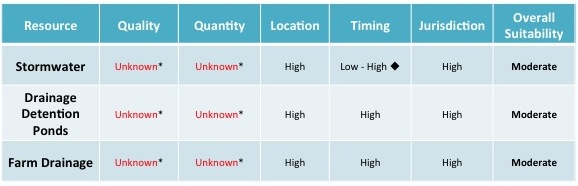
Drainage Detention Ponds: High potential for agricultural production
Function: flood management; aquatic habitat; recreation
The primary purpose of Surrey’s drainage detention ponds is to provide flood management for stormwater runoff originating from the urbanized and impervious upland areas in Surrey, White Rock, and Langley. In area where rates of surface runoff are high, detention ponds can provide space for water to be stored and slowly infiltrated into groundwater or drainage channel systems. Furthermore, the ponds provide the additional of benefit of slowing down the velocity of the runoff and providing opportunity for the water to settle and filter, thus reducing contamination and improving the water’s quality. The ponds can be found in wet (above ground) or dry (below ground) forms. In Surrey, many wet drainage detention ponds are vegetated and landscaped in order to also provide both wildlife habitat and a park setting for Surrey residents.
Location: high potential around ALR boundaries
Due to the geologic and topographic nature of Surrey’s uplands and lowlands, water tends to flow from the impermeable upland areas to the lowlands. Urban development, with its tendency to include high amounts of impermeable surfaces, can accentuate this natural direction of water flow.
Quality: unknown
Stormwater runoff can contain a variety of impurities coming from urban sources, including fecal matter, road salts, heavy metals, and industrial pollution. The quality of drainage detention ponds is not monitored by the city of Surrey at this time.
Quantity: unknown
The quantity of water entering and being held in drainage detention ponds is not monitored by the city of Surrey at this time; however the number of detention ponds in existence indicate that there are significant quantities of stormwater that require management.
Timing: high potential
Although stormwater detention ponds receive the bulk of their water inputs in the winter months when precipitation is highest, their ability to store and filter water may enable them to provide significant quantities of high quality water for agriculture during the summer growing season months.
Jurisdiction: City of Surrey
Stormwater and drainage detention ponds are currently managed by the Engineering Department of the City of Surrey.
Summary:
Works Cited:
[1] Loucks, D. P. (2000). Sustainable Water Resources Management. Water International, 25(1), 3–10. http://doi.org/10.1080/02508060008686793
[2] Huibers, F. P., & Van Lier, J. B. (2005). Use of wastewater in agriculture: The water chain approach. Irrigation and Drainage, 54(SUPPL. 1), 3–9. http://doi.org/10.1002/ird.181
[3] Page, N., Rood, K., Holz, T., Zandbergen, P., Horner, R., & McPhee, M. (1999). Proposed Watershed Classification System for Stormwater Management in the GVS & DD Area. Burnaby. Retrieved from http://www.raincoastappliedecology.ca/wp-content/uploads/2012/05/Proposed-Watershed-Classification-System-for-the-GVSDD-Area.pdf
[4] Swain, L., & Holms, G. (1988). Ambient water quality objectives for Boundary Bay and its tributaries, Fraser-Delta area : overview report. BC Ministry of Environment and Parks: Water Management Branch, Resource Quality Section. BC Ministry of Environment and Parks.
[5] Finkenbine, J. K., Atwater, J. W., & Mavinic, D. S. (2000). Stream health after urbanization. Journal of the American Water Resources Association, 36(5), 1149–1160.
[6] Halstead, E. (1978). Nicomekl-Serpentine Basin Study, British Columbia. Fisheries and Environment Canada: Inland Waters Directorate, Pacific and Yukon Region, Water Resources Branch. Vancouver: Fisheries and Environment Canada.
[7] Juteau, C. (2008). Ministry of Environment. Surrey. Retrieved from http://www.env.gov.bc.ca/epd/regions/lower_mainland/water_quality/reports/ltl-campbell-riv/pdf/LCR-wq-monitor.pdf
[8] Bull, J., & Freyman, L. (2013).
[9] Finkenbine, et al. (2000).
[10] Bull, J., & Freyman, L. (2013).
[11] City of Surrey. (2015). City of Surrey Website. Retrieved July 20, 2015, from Sustainable Drainage: http://www.surrey.ca/city-services/3646.aspx
[12] Bull, J., & Freyman, L. (2013).
[13] Page, N., et al. (1999).
[14] Bull, J., & Freyman, L. (2013).
[15] Juteau, C. (2008).
[16] Town, C. A., Mavinic, D. S., & Moore, B. (1989). A study of water quality in an urban river and potential improvement using a prototype instream aerator. Canadian Journal of Civil Engineering, 316, 308–316.
[17] Payette, K. (2004). Water Quality Assessment of Watercourses Used for Irrigation of Ready-To-Eat Produce in Cloverdale, BC: Summer 2002-Spring 2004. Surrey. Retrieved from http://www.env.gov.bc.ca/epd/regions/lower_mainland/water_quality/reports/ready-to-eat/ready_to_eat.pdf
[18] Bull, J., & Freyman, L. (2013).
[19] Bull, J., & Freyman, L. (2013).
[20] Golder Associates. (2005). Report on Nicomekl – Serpentine Water Supply and Quality Assessment. Abbotsford.
[21] Zevit, P., Page, N., & Goble, H. (2008). Ministry of Environment Characterization of Potential Pollution Sources in the Little Campbell River Watershed. Surrey. Retrieved from http://www.env.gov.bc.ca/epd/regions/lower_mainland/water_quality/reports/ltl-campbell-riv/pdf/pollution-ltl-camp-riv.pdf
[22] Water Act (RSBC 1996, C483) Retrieved from: http://www.bclaws.ca/civix/document/id/complete/statreg/96483_01
[23] Golder Associates. (2005).
[24] Zevit, P., Page, N., & Goble, H. (2008). Ministry of Environment Characterization of Potential Pollution Sources in the Little Campbell River Watershed. Surrey. Retrieved from http://www.env.gov.bc.ca/epd/regions/lower_mainland/water_quality/reports/ltl-campbell-riv/pdf/pollution-ltl-camp-riv.pdf
[25] BCMA. (2013). Land Use Inventory Report: City of Surrey – Summer 2010. Abbotsford.
[26] BCMA. (2013).
[27] Zevit, P. et al. (2008).
[28] Natural Resources Canada. (2005). GeoMap Vancouver. Retrieved July 26, 2015, from Natural Resources Canada: http://ftp2.cits.rncan.gc.ca/pub/geott/ess_pubs/209/209909/gscof_3511_e_1998_mn01.pdf
[29] Zevit, P. et al. (2008).
[30] Duke, K. (2014). Ownership of rainwater and the legality of rainwater harvesting in British Columbia. Appeal, Review of Current Law and Law Reform, 119, 21–42.
[31] Golder Associates. (2005).
[32] BCME. (2015). BC Water Resources Atlas. Retrieved June 30, 2015, from BC Ministry of the Environment: http://maps.gov.bc.ca/ess/sv/wrbc/
[33] Halstead, E. (1978).
[34] Golder Associates. (2005).
[35] Wilson, J., Schreier, H., & Brown, S. (2008). Arsenic in Groundwater in the Surrey-Langley Area For : Environmental Health Services.
[36] Halstead, E. (1978).
[37] BCME. (2015).
[38] Golder Associates. (2005).
[39] Golder Associates. (2005).
[40] Golder Associates. (2005).
[41] BCME. (2015).
[42] Golder Associates. (2005).
[43] BCME. (2015).
[44] BCME. (2015).
[45] Golder Associates. (2005).
[46] BCME. (2015).
[47] Wilson, J., Schreier, H., & Brown, S. (2008). Arsenic in Groundwater in the Surrey-Langley Area For : Environmental Health Services.
[48] Province of British Columbia. (2015). Licensing Groundwater Use Under British Columbia’s Water Sustainability Act. Retrieved July 30, 2015, from http://engage.gov.bc.ca/watersustainabilityact/files/2015/07/LicensingGroundwaterUse-Web-Copy.pdf
[49] Water Sustainability Act (2014, Bill 18) Retrieved from: http://leg.bc.ca/40th2nd/3rd_read/gov18-3.htm
[50] Province of British Columbia. (2015b). The New Groundwater Protection Regulation Under B.C.’s Water Sustainability Act. Retrieved from http://engage.gov.bc.ca/watersustainabilityact/files/2015/07/GroundwaterProtectionRegulation-Web-Copy.pdf4