In this Lab, we created a map of Vancouver that showed areas susceptible to a tsunami and located health and educational facilities within the danger zones as well as placed polygons for potential signage areas.
Here is the map of Vancouver with danger zones and roads/facilities affected:
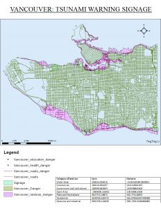
The following healthcare facilities situated in the danger zones are:
- False Creek Residence
- Villa Cathay Care Home
- Broadway Pentecostal Lodge
- Yaletown House Society
The following education facilities situated in the danger zones are:
- ECIAD
- Henry Hudson Elementary
- False Creek Elementary
- St. Anthony of Padua
- Ecole Rose Des Vents
I was able to locate these facilities by creating a new layer that intersected only the points (representing the facilities) that lie within the danger zones. Then, I looked in the layer’s attributes table to find their names.
Next, I created a map that approximately outlined where St. Paul’s Hospital will be, under the context of the previous map of Vancouver with hazardous areas.
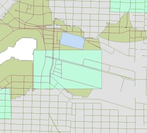
As you can see, the blue polygon, which represents the hospital, is located exactly within the green area. Green areas represent places that will be heavily affected by a tsunami. Not only is the hospital in danger, but the roads accessing the hospital are also mostly red, which means these roads are also in danger.
St. Paul’s Hospital is making a mistake in this location in terms of a tsunami. The hospital itself is under threat and ther is also no way to remove patients or staff from the hospital safely because the roads surrounding it are also under threat.