During the last few weeks of our GEOB 270 Introduction to Geographic Information Sciences class, we were assigned a final project where we had to assess and analyze a problem using maps and ArcGIS tools. My group mates Gillian, Ramon and Nathan decided to evaluate the viability of the Salish Sea as a continued habitat for the Southern Resident Orca Whales (SROW).
Our project will identify the areas of poor habitat in relation to the SROWs which will then allow us to determine if the Salish Sea is a viable area for a cetacean sanctuary. Our study area is the Canadian portion of the Salish Sea which includes the Juan de Fuca Strait, the Georgia Straight and the Johnstone Straight. As of the most recent study in 2014, there are only 78 SROWs remaining in the Salish Sea (NOAA Fisheries, 2015) as they are being faced with intense habitat disruption which includes aquatic noise pollution from daily ferry, tanker and cruise ship traffic (Ramanujan, 2010), lower salmon populations for their daily food supply as well as many industrial sites that are along the coasts that produce copious amounts of industrial waste (NOAA Fisheries, 2015)
Project Management
All four of the group members participated in acquiring data, the research, the proposal of the project, the analysis of our maps and the final report write up. We met every Tuesday during our lab time to discuss the maps and to divide out sections of the final report that each person was responsible for writing. We also met outside of our lab time to allow extra time for us to ensure that our project would be completed on time.
Project Results
Our maps below highlight different impacts to the Southern Resident Orca Whales. As of a study in 2014, it was revealed that only 78 Southern Resident Orcas remained (NOAA Fisheries, 2015). Some of these impacts to the SROW habitat are ferry routes, cruise ship routes, shipping terminals, coastal industry sites, dams and saltwater fish farms.

In our first map, we outline the specific vessel routes that would produce aquatic noise pollution for the SROWs. We learned that vessel noise travels 19 kilometres from the original source (BC Cetacean Sightings Network, n.d.). We applied a buffer layer to our map with this 19-kilometer buffer around all vessel routes but when we did that we found that the map was illegible as there was no empty space that the SROWs could live in. Even though ships produce variable levels of noise, any noise levels will affect the Southern Residents and the noise will have prolonged and serious population impacts (Weilgart, 2007).
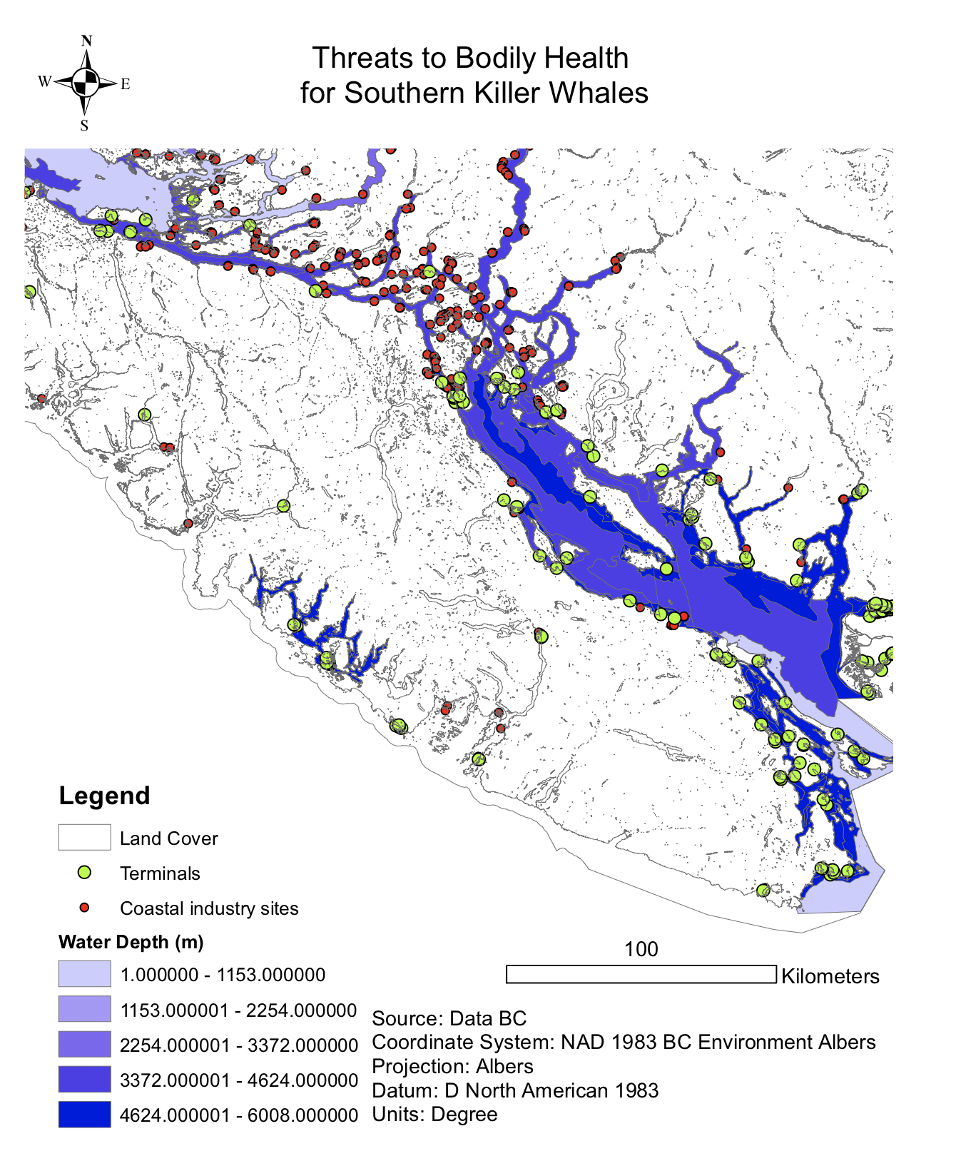
In our second map, we analyzed the effect that coastal industry sites had on the SROWs. We found that through bioaccumulation, the buildup of chemicals within organisms through the food chain (Michigan Government, n.d.), the SROWs are facing very concentrated and large amounts of toxins from the waste that the sites are producing. Biomagnification occurs when small organisms take in these dangerous toxins and since they are not digestible, they accumulate in the animals and become more concentrated as they are passed up through the food chain (NOAA, n.d.). The pollutants that are being spread throughout rivers and the sea can cause diseases, genetic mutations, birth defects, reproductive difficulties and death in marine animals (NOAA, n.d.). Toxins can also be passed from an adult female to its calf through lactation which makes the concentration in adult males 30% more than in adult females because they pass a large, concentrated amount of toxins to their baby (BC Cetacean Sightings Network, n.d.).
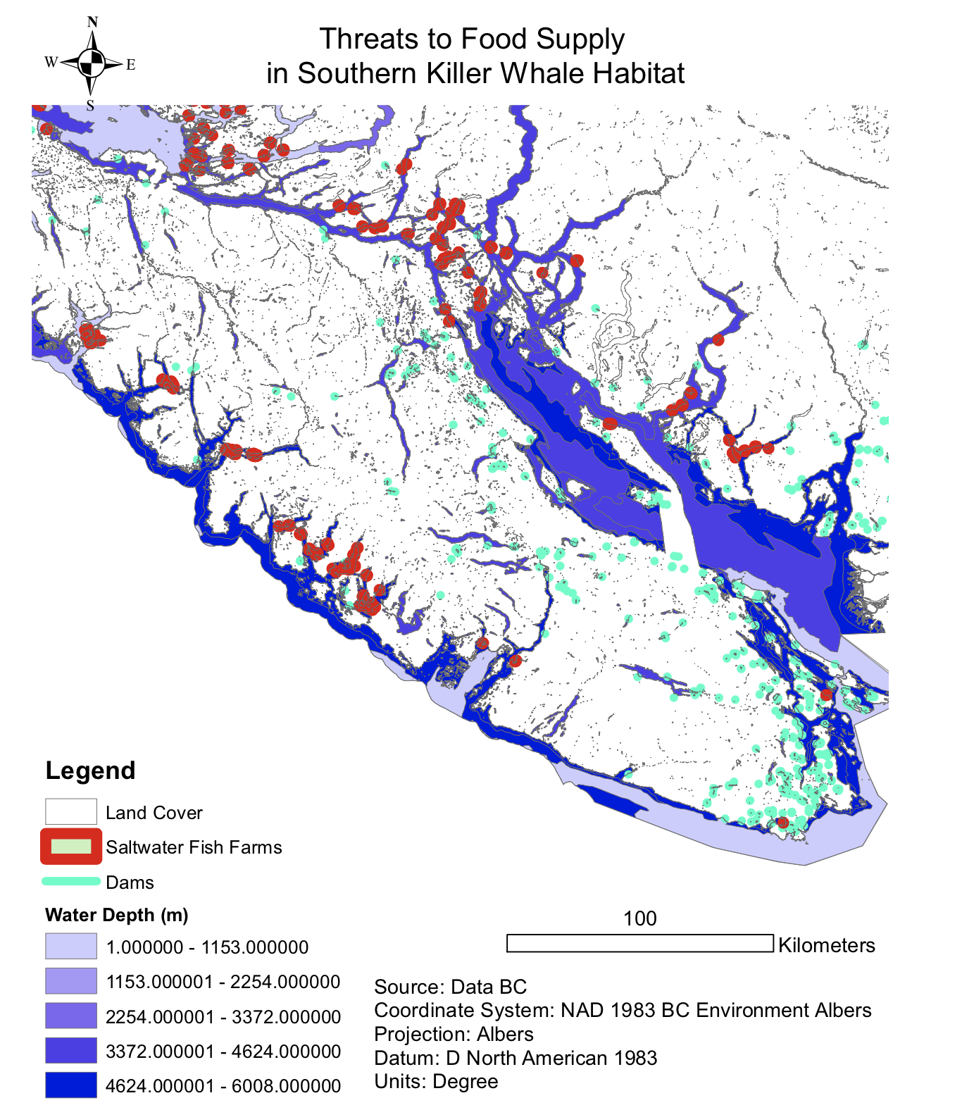
In our third map, we analyze the threats to the killer whale’s food supply. This map shows the dams and salt water fish farms that are impacting this supply of salmon. The dams block access for spawning wild salmon which further impacts the number or returning salmon to the spawning grounds resulting in a lower population overall. Parasitic Sea Lice is endemic to the Atlantic salmon populations which affects the wild salmon populations. The sea lice have a direct effect on the scales of the fish and juvenile salmon are quite susceptible. An article published in 2016 says that up to 40% of juvenile wild salmon has been killed from the fish farms and their poorly timed treatments and the warm environmental conditions that have created a larger our break of the sea lice (Bateman, 2016).
Fish packaging plants that harvest the Atlantic salmon have been dumping the blood of the salmon remains directly into the ocean. The biohazardous waste can contain viral infections that are endemic to Atlantic salmon.
The migration routes of the salmon are on a path of the industrial sites, the fish farms and the fish packaging centres which are reasons as to why the SROW food populations are diminishing.
All three of these maps work together to prove that the Salish Sea is not a viable habitat for the SROW and that intense actions are needed to transform this area into a cetacean sanctuary as it would involve a drastic reduction of aquatic noise, strict controls on coastal industry, and banning fish farms that are in the migration routes of the wild salmon.
Error and Uncertainty
There are always notable limitations when gathering data from the government. One error was when the DataBC layer had an island in the Strait of Georgia that was connected to Vancouver Island. We also had difficulty gathering specific information on the salmon runs and cetaceans sighting as when we requested this data, we were denied access to it. The lack of transparency with this data is concerning. We also had to generalize some of our findings as the fish farms were produced as very small polygons so we had to fit them to our scale and apply a large outline so they were visible. This could impact the accuracy of the points and create error. Another error is that the dammed streams within our analysis were not all necessarily Chinook bearing streams.
Further Research and Recommendations
We recommend that further research can be conducted on what realistically needs to happen in order to turn the Salish Sea into a cetacean habitat and how that can be accomplished. Research can be conducted on how to diminish emittance of aquatic noise and the amount of sea vessel traffic and what kind of polices or incentives can be implemented to made sure that there is a reduction of impacts on the SROW. We also recommend that proper and thorough environmental impact assessments are done on large projects that might interfere with the SROW. For example, the Kinder Morgan Trans Mountain Pipeline Expansion project would increase tanker traffic by seven times (Kinder Morgan, n.d.) but there was not an environment impact assessment done on the impact that this project would have on the SROW because they felt that it was not necessary and that the expansion would not impact the habitat of the SROW.
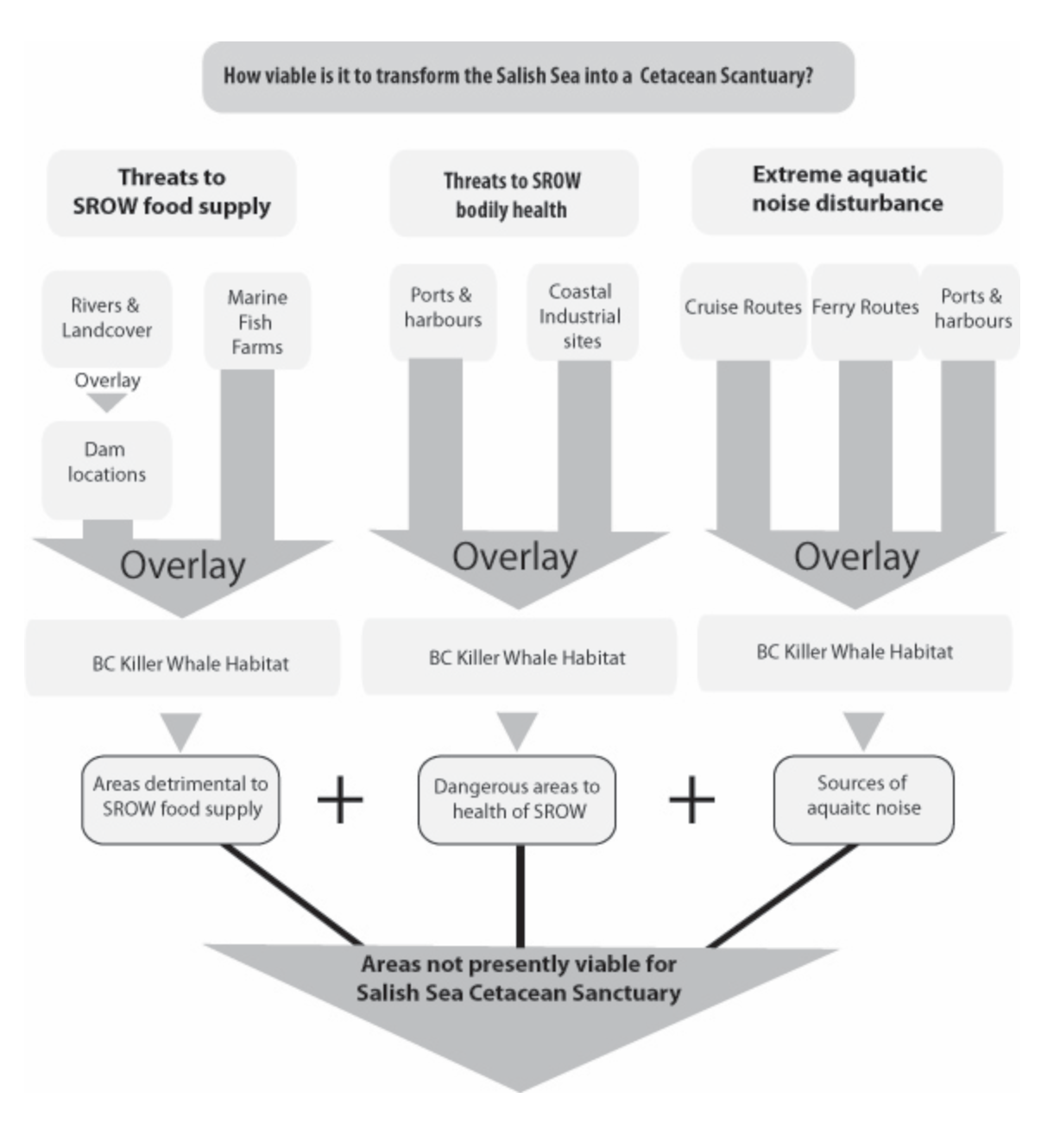
Flow Chart
Below is the flow chart that includes a detailed look at the steps we used using the program ArcGIS to create all of our maps.
 Conclusion
This project has been very eye opening as I had no clue at the start of the project of how threatened these amazing mammals are and how there are so many impacts to the SROW and if nothing happens then their population will continue to diminish until they are an extinct species.
If you are interested in reading our full report on the Viability of the Salish Sea for the Southern Resident Orca Whales then please use the link below:
Evaluating the Viability of the Salish Sea as a Cetacean Sanctuary at Present
References:
Bateman, A. W., Peacock, S. J., Connors, B., Polk, Z., Berg, D., Krkošek, M., & Morton, A. (2016). Recent failure to control sea louse outbreaks on salmon in the Broughton Archipelago, British Columbia. Canadian Journal of Fisheries and Aquatic Sciences,73(8), 1164-1172. doi:10.1139/cjfas-2016-0122
BC Cetacean Sightings Network. (n.d.). Noise. Retrieved December 04, 2017, from http://wildwhales.org/threats/noise-and-cetaceans/
Kinder Morgan – Canada. (n.d.). Kinder Morgan – Trans Mountain Expansion Project. Retrieved November 20, 2017, from https://www.kindermorgan.com/pages/business/canada/tmep
NOAA. (n.d.). Biomagnification. Retrieved December 04, 2017, from http://oceanexplorer.noaa.gov/edu/learning/player/lesson13/l13la1.html
NOAA Fisheries. (2015, June 22). Species in the Spotlight: Southern Resident Killer Whale. Retrieved November 21, 2017, from http://www.nmfs.noaa.gov/stories/2015/06/spotlight_srkw.html
Ramanujan, K. (2010, February 22). Acoustic maps of ocean noise reveal how shipping traffic affects whales. Retrieved November 21, 2017, from http://news.cornell.edu/stories/2010/02/sound-maps-reveal-whales-and-noise-pollution
Weilgart, L. (2007). The impacts of anthropogenic ocean noise on cetaceans and implications for management. Canadian Journal of Zoology, 85(11), 1091-1116. doi:10.1139/z07-101