
Retrieval of location data for all car share parking spots was difficult due to the restrictions in privacy policies. Our group contacted all four companies regarding location data, however Car2Go and Evo were not able to distribute spatial data, Zipcar had no response and Modo location data was given via email.

Source: UBC Planning
Modo
Modo location data was given for all car spots, as well as the number of cars per location. The original data was in JSON format, which we converted to a CSV file. In ArcMap, the CSV file was imported and exported as a X Y Event Layer. Since the original data had fields that specified the longitude and latitude of each parking location, a point layer with all the spots was produced, named Modo_Parking_Locations (Figure 2). Projection transformations using Project was performed to correct the datum discrepancies.
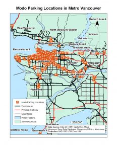
Figure 2. Modo parking locations in Metro Vancouver.
Source: Wikipedia Commons
CAR2GO
Location data for car2go was not given by the company. Instead, each car2go ParkSpot in the Metro Vancouver study area was digitized manually using Editor. A point layer ,named Car_to_go_locations (Figure 3) was created by comparing the addresses on the car2go website and using the Find tool to locate the intersections. Along with Google Maps, each point was placed in the exact location as the ParkSpot map on the company’s website. The attribute table was populated with fields that included the cities and the AdminBoundary layer name. This was done to ensure that joins or relates run smoothly in the future.
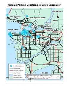
Figure 3. Car2Go parking locations (ParkSpots) in Metro Vancouver.
Source: Zipcar.com
Zipcar
Location data for Zipcar locations were also not given and had to be digitized manually using Editor. Each Zipcar parking location was created as a point layer, named Zipcar_parking_locations (Figure 4), spatially referenced by comparing the addresses on the Zipcar website. Google Maps was also used to correct for any discrepancies in the Zipcar data. The attribute table for this layer was also populated with Adminboundary and CIty fields to make address location easier in future analysis.

Figure 4. Zipcar parking locations in Metro Vancouver

Source: BCAA, Evo.ca
Evo
Location data for Evo car share locations was also not given. Instead, each parking location was digitized manually into a point layer, named evo_parking_locations (Figure 5). Addresses from their map on the website were compared with our Roads layer using the Find tool. Alike car2go and Zipcar, Google Maps was used to implement the intersections and correct for any errors in placement. Adminboundary and City fields were populated with the city names.
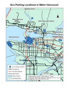
Figure 5. Evo parking locations in Metro Vancouver.
To be plotted as one layer, all four car share point layers were merged using the Merge tool under “Geoprocessing” to create the layer named parking_locations_merged (Figure 6).

Figure 6. Map showing the merged points of all parking locations in the four companies.