In this lab, I learnt how to acquire spatial datasets online, parse and filter data based on analytical objectives, evaluate and use different spatial analysis tools, and developed my cartographic and written communication skills by producing a map and short memo summarising my results for a non-technical audience.
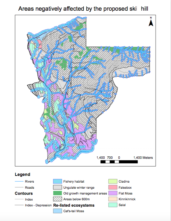
Map showing areas negatively affected by the proposed ski hill:

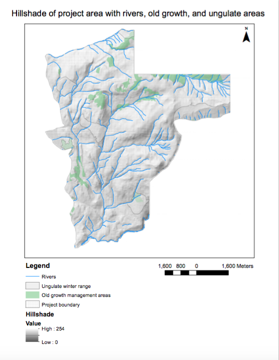
Map showing hillshade of project area with rivers, old growth and ungulate areas:

Memo:
The British Columbia Snowmobile Federation (BCSF) is a province-wide organisation of over 45 snowmobile clubs and grooming societies. The federation is focused on safety, the growth of the sport, protection of the environment and securing access to public lands for all. Since its inception in 1965, the BCSF has been campaigning for the preservation of riding areas, as well as conservation and the careful use of BC’s backcountry.
The Garibaldi at Squamish project is a proposed year-‐‑round destination mountain resort on Brohm Ridge. As of January 2016, this project has been tentatively approved, with 40 conditions and includes 124 ski trails and 21 lifts, resort accommodation and commercial developments.
As a natural resource planner, engaged by BCSF, and my job is to examine the Environmental Assessment’s recommendations and Whistler’s criticism to evaluate whether there is sufficient evidence to continue to oppose the Garibaldi at Squamish project, or whether these environmental concerns can be addressed as part of the project.
It is understood that the project proponents (Northland Properties and Aquilini Investment Group of Vancouver) submitted an application for a Project Approval Certificate under the Environmental Assessment Act in 1997. Subsequently, in 2010, the BC Environmental Assessment Office released a report stating that the Garibaldi at Squamish project lacked information on the potential effects on vegetation, fish, and wildlife habitat, and recommended a series of measures to prevent or reduce any significant environmental, social, economic, heritage and health effects. In April 2015, the project proponents filed a supplemental application that they claimed addressed these issues. During the subsequent community consultation process in May and June 2015, the Resort Municipality of Whistler submitted a letter opposing the project. In addition to its concerns over the economic viability and impact of the project, Whistler questioned the possibility of reliable skiing on the lower 600m of the vertical, considering the climate of the area and climate change.
To address the Resort Municipality of Whistler’s concern about the possibility of reliable skiing on the lower 600m of the vertical, given the climate of the area and climate change in the 21st century, I have used Geographical Information Science (GIS) and calculated the area of the project area that is below 600m. Through my analysis, it is observed that 31.8% of the proposed project area is on the lower 600m of the vertical. This is quite a significant area of the project that may not be suitable for skiing as there will not be enough snow there.
To verify the Environmental Assessment of the project area, I used GIS to calculate the area that will be negatively affected by the proposed ski hill. In order to accomplish this, I retrieved data regarding ungulate winter range, old growth management areas, project boundary, areas with red-‐‑listed ecosystems, elevation, parks and protected area boundary, roads and rivers of the area. GIS allowed me to overlay these data and produce a map to highlight the areas that will be negatively affected by the project. The project will affect areas with old growth forests, areas of Mule Deer and Mountain Goat winter habitat, areas with red-‐‑listed ecosystems, and areas that fall within fish bearing streams or within fish habitat/riparian areas around streams.
From the map produced (refer above), it is clear that 65.8% of the project area will be negatively affected by the project. Specifically, 6.78% of the project area has old growth forest, 7.89% has Mule Deer and Mountain Goat winter habitat, 24.8% has red-‐‑ listed ecosystems, and 26.3% of the project area will fall within fish bearing streams, or within fish habitat/riparian areas around streams. As such, it is observed that the two greatest environmental concerns to the project development is its effect on red-‐‑listed ecosystems and the river systems in the area.
As a natural resource planner, I believe the best way to mitigate this environmental impact is to reduce the area of the project, specifically the southwest region of the proposed area. The southwest region of the project area has the greatest density of red-‐‑ listed ecosystems and river systems of the area.
In conclusion, the proposed ski hill will have severe environmental impact on the area. While it might be possible to mitigate these environmental effects, the area will nevertheless be subject to environmental damage with the development of the project. Furthermore, the project may not be economically viable either as a significant portion of the proposed area will be unable to serve its purpose as a ski hill.
Personal response:
When working on environmental projects, it is possible to be involved in proposals that I do not ethically believe in. Personally, I would not want to compromise on my own values and beliefs. If possible, I will remove myself from the project and attempt to prevent the project from happening. If this is not possible, I will try to find a middle ground. However, I recognise that this may not always be possible as everyone will be focused and vying only for their desired outcome, regardless of the aftermath of the project.