
Thanks to such an intense ‘preparation’ from the last lab, I was rather confident enough in my accumulated GIS expertise not to completely breakdown in sweats and nervousness for this week’s lab. It is the ultimate self-dependence assignment before embarking onto our final project, but to me this is the last barrier, the last boss in the game that once I am able to have a triumph over it, nothing ArcGIS-related will be of bother anymore (quite ambitious statement, but still inapt in reality). Anyways, this week’ topic was on environmental assessment, specifically on the Garibaldi at Squamish project while my approach toward the project was as a natural resource planner who has been retained by the project proponents. My task was to develop evaluations and recommendations to the proponents as to what the priorities are in order to proceed with their proposal.
Introduction
The proposed project is named the ‘Garibaldi at Squamish’ which is designed to be a year-round mountain resort, locating on Brohm Ridge near Squamish community in the Northern Vancouver. My involvement in this process, as a natural planner recruited by the project proponents, is to reevaluate the project based on the received criticisms regarding potential environmental and wildlife concerns, from the BC Environmental Assessment Office and Resort Municipality of Whistler, and to make subsequent recommendations to the proponents on their priorities regarding the concerns.
Addressing the concerns
In offering my evaluations and recommendations, I have operated on the ArcGIS program to conduct an analysis on the proposed project and to make visual aids (i.e. maps) in assisting the analysis. The input data layers are project boundary, roads, rivers, 20m. contour line, DEM, ungulate winter habitat, old growth forest zones, and terrestrial ecosystem areas.
Firstly, by operating command ‘clip’ based on the project boundary layer, the analysis can concentrate solely on the area of the proposal. For DEM layer, I reclassified and converted the file to vector in order to establish the snowline which is above 555m. of vertical. For terrestrial ecosystem layer, I selected, by attributes, areas of certain endangered species, created a new layer out of it, called ‘redlisted’ and made a endangered-species map. For river layer, I used the buffer command to verify the riparian areas within the project boundary. Then in order to visualize the protected area, through union command, I combined layers of ungulate winter habitat, old growth forest zones, ‘redlisted’ and riparian areas together. Hence, by aligning the protected areas with the project boundary, the final map was made to collaborate in my analysis of this project.
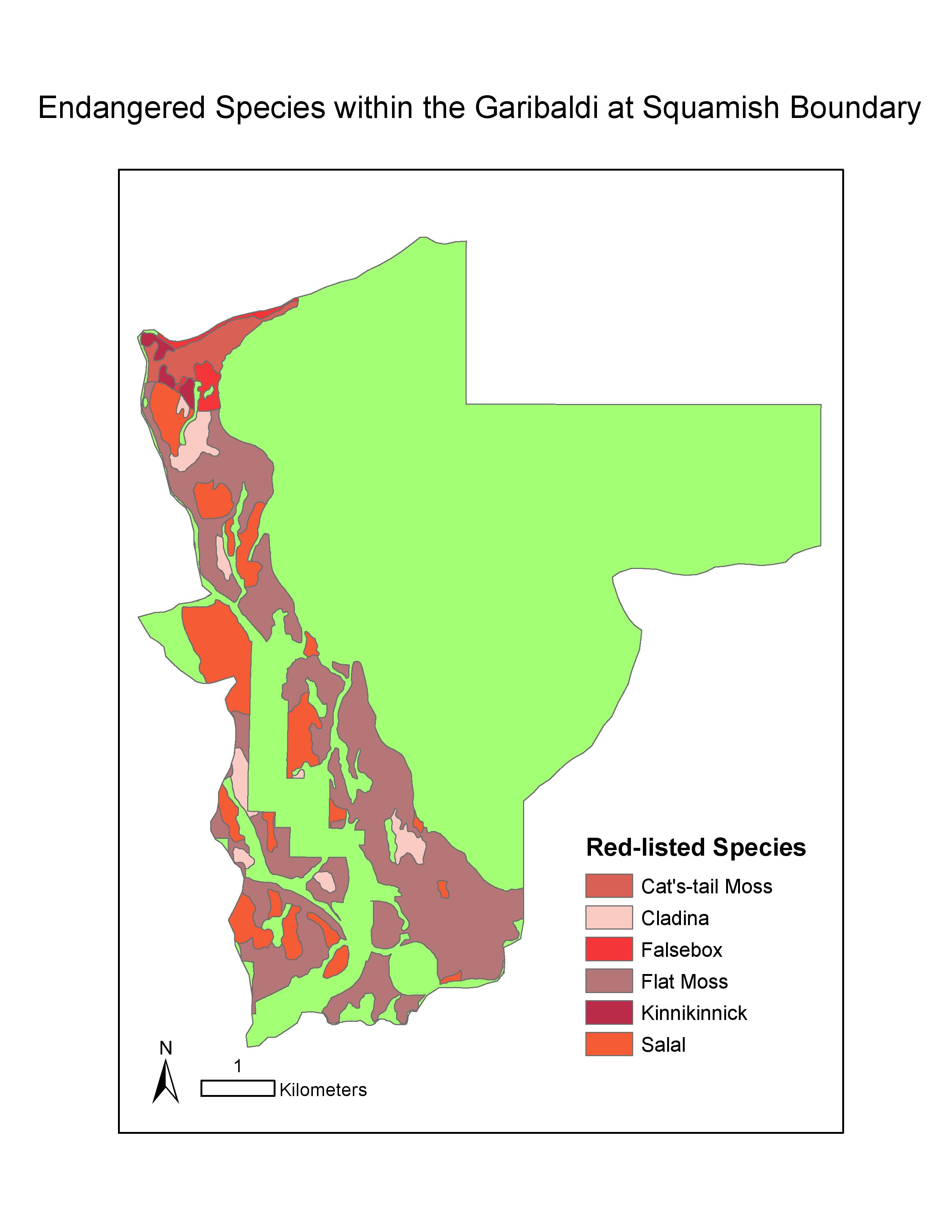
Map1: Locations of the endangered species within the proposed project boundary
The result shows that more than 50% of the project area could potentially have direct impacts to the environment within the boundary: 6.78% on old growth forest zones, 7.89% on the ungulate winter habitat, 24.83% on endangered ecosystem areas and 26.01% on the riparian areas. Moreover, 29.92% of the total area is below 555m. of vertical which is cited by Resort Municipality of Whistler to be outside of the snowline.
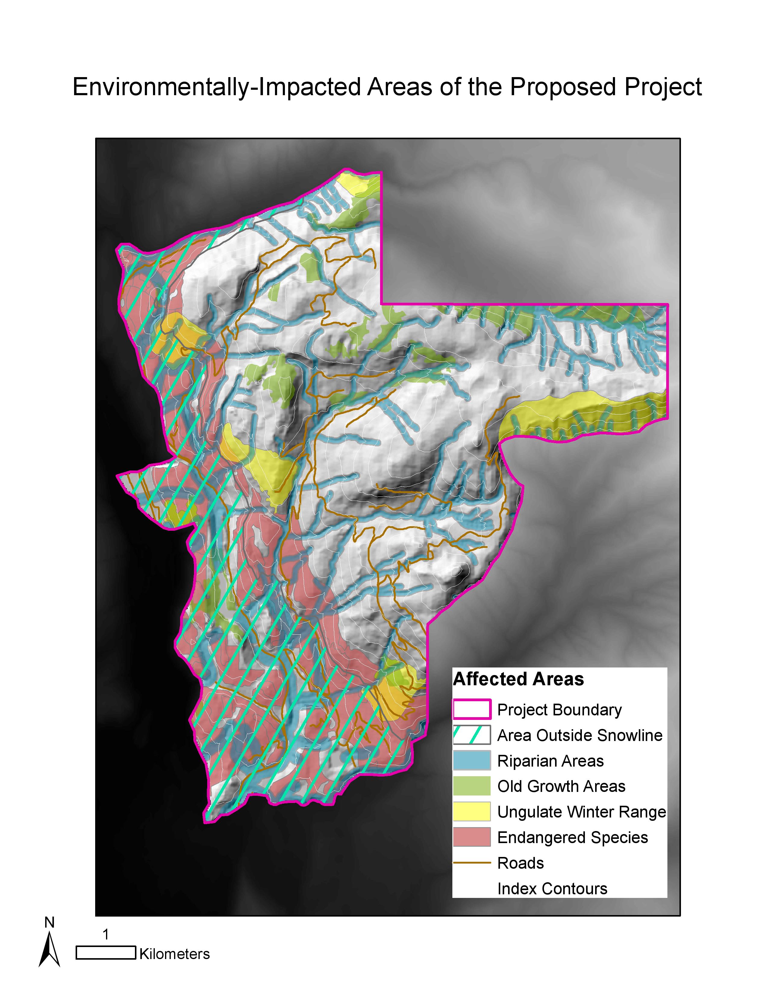
Map2: Environmentally-impacted areas of the proposed project
Sequential recommendations
According to the result of the analyses, as a natural planner, I would recommend the project proponents to prioritize their consideration more on the riparian areas and the endangered ecosystem areas. This is because they are the potentially two greatest environmental concerns within ‘Garibaldi at Squamish’ boundary. My prominent recommendations would be not to construct any infrastructure on such areas, and to do a field survey around those areas to make sure that they will not experience any peripheral disturbance or damage from neither the resort construction or the resort existence itself.
Personal reflection
Considering the outline of the proposal and the result of the environmental assessment, I do not agree to the construction of the resort for various reasons: (a) it is built within the First Nations land in which the community would surely be affected by such large-scale project of a year-round resort and (b) the construction and the existence of the resort itself create disruption to the natural habitat and pattern of both plants and animals in the area, despite receiving the approval certificate from the BC Environmental Assessment Office. These disagreement are expressed from my stand as a member of the society, however, in a role as a natural resource planner, my judgement has to maintain as unbiased as possible, that is to report only the result of the analysis, not being clouded by my personal opinion. In other words, there is an overlap between my personal disagreement and the analysis outcome on the project in the memo, sharing certain concerns but not identical.
×W’s picked-up skills×
- introduced to publicly available source of data and acquired only the suitable format of data for ArcGIS marking the beginning of the analysis
- reclassified the DEM data on the value of elevation to verify the suitable area for the resort construction
- operated the select by attributed tool to identify certain features within the red-listed ecosystems, the ungulate winter ranges, and the old growth forest for the visualization of the environmentally-impacted areas for the resort construction
- generated an environmental assessment map as a visual aid, and made a memo for the analysis of the resort construction and its potential impact to the preexisting biodiversity