For the last two weeks of the term, ‘the final project’ was the absolute focus of my life. My schedule was revolved around the project; basically, it is safe to claim that I had lived and breathed for the completion of this project. Why? Because this was somehow such an entertainingly challenge to tackle. You are equipped with fundamental understandings of the process, and the opportunity to execute some awesome GIS analysis project of your choice. How can one not be excited about it? Well, this excitement might not apply to everyone, but it certainly is for me!
Planning for a new NHL Arena in Phoenix, AZ: Exploring Site Suitability using GIS Analysis
Introduction
The Arizona Coyotes (a National Hockey League franchise) are looking for location with Phoenix, AZ, to build their own arena, replacing their station location since 2013 at Gila River Arena in the city of Glendale, AZ. Noticing the promise of such opportunity, our project intended to evaluate for the optimum potential locations for the new Arizona Coyotes arena within the city of Phoenix, by using ArcGIS as the means of analysis.
Methods
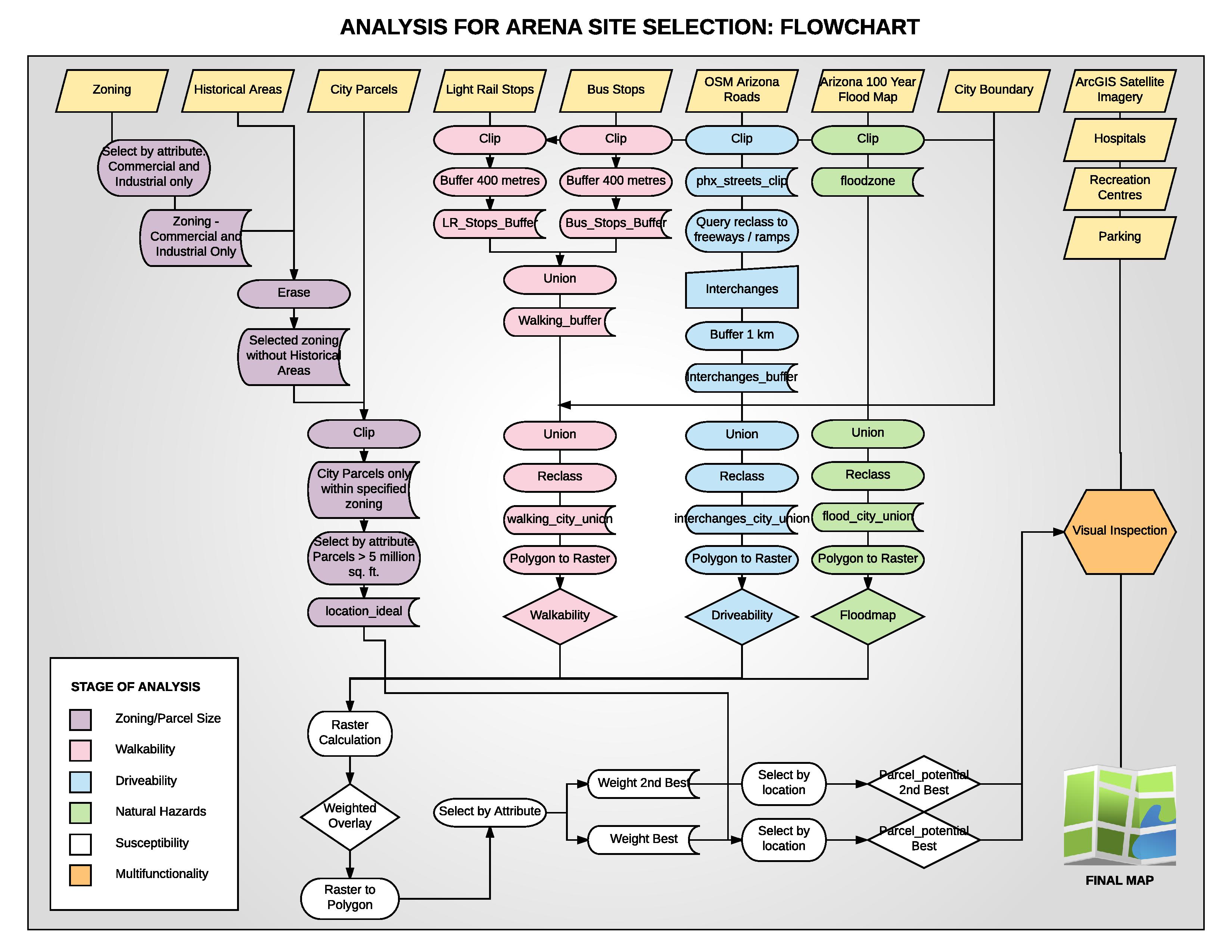
First, we acquired all necessary spatial data through various sources which were the OpenStreetMap, City of Phoenix Open Data, and ArcGIS Open Data. Then we decided that the analysis project ought to be separated, for efficiency and simplicity, into two steps (See Flowchart below): (i) determining the available land parcels with proper size , and (ii) evaluating city’s zone of susceptibility through weighted based on the following criteria- within walking distance from public transport, within convenient driving distance from freeways and major roads and, lastly, outside of the flood zones in Phoenix.
Step (i) involved mostly with the exclusive use of selection by attribute to reach a result of parcels in either commercial or light industrial zoning, outside of the historical zone and within proper size of determined five million square feet. On the other hands, step (ii) were complicated with repeated procedures and series of commands to conclude with areas qualifying within the flood-free, the walkable and the drivable zones. Then, after combining the results from these steps, we had the parcels potential outcome which, through visual inspection to determine the mutifuntionality of the future locations from the existing facilities (hospitals, recreational centers and parking areas), we had the final map for options of the optimum locations for the new Arizona Coyotes arena.

Flowchart illustrating the overall process
Results and Discussion

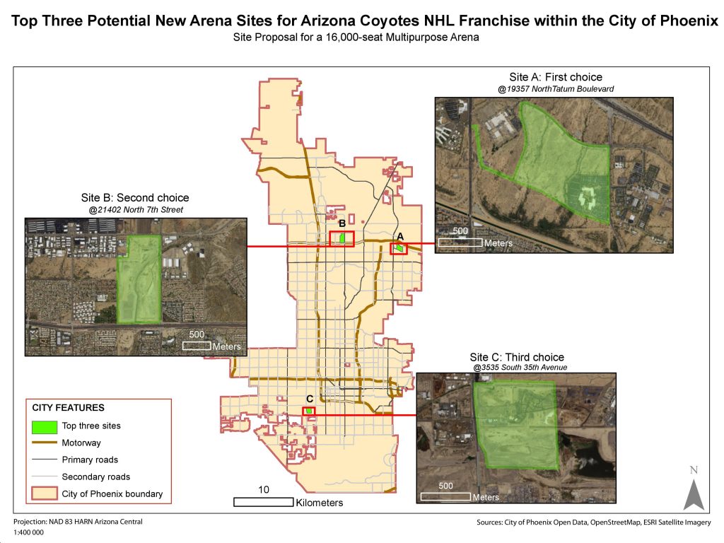
Map1: (the final product) Top three potential new arena sites for the Arizona Coyote NHL within the city of Phoenix
Site A: Determined to be the best option, we were able to definitively conclude that its close proximity to public transport, freeway interchanges and distance from flood zones, all allowed for it to be the discernibly superior option. Furthermore, the site sits close to a hospital, has 8 hundred thousand square feet. of pre-existing parking lots on site and the locale is serviced by only one other recreation center. The one drawback that must be addressed is far from the city hub. Without data on the location of the fan base this may prove to be either a negative, positive or a null inquiry.
Site B: The decision to rank this plot second was based on the accessibility of public transport and its location outside of the flood zone. Moreover, based upon satellite imagery it appeared that Plot B was largely undeveloped, implying that any demolition-related costs could be reduced.
Site C: Though Plot C was our third choice, it lacked many of the qualities of the previously described locations. Positives of this site were its location to public transport and major highways. Additionally, from satellite imagery, Plot C is largely undeveloped. From a negative perspective, this site had parts existing in the 100 year flood zone. This would affect both the overall structure of the building and the insurance associated to a building in a flood zone. Moreover, the surrounding area was already serviced by two recreation centers, and lacked any hospital and significant parking lots within the boundary.
In conclusion, it can be stated that the most preferred option was Plot A. This was due to the locations adherence to our criteria, most notably as it was the only site which was successfully adjacent to a hospital, far from any recreation centers, had substantial parking areas, was greater than 5 million square feet, and within areas of accepted walkability and drivability.
Team Management
This group (Wasinee, Kanchi, Templar and Stephen) dynamic had balanced itself in a rather satisfying manner where half of us worked mainly on the map, while the other halves were in charge of figures and the report. Cross-section between these two aspects of the project had happened occasionally, since the details about the map naturally had to be writing out in the report and vise versa. All members were active for finding the data layers, then our responsibilities had spread out since, but within three majors grounds: to make maps, to arrange the flowchart and to build the report. We rarely had tension among the member’s opinion, but did appeared a slight irritation on the work distribution. Fortunately, the members are of hard workers. So instead of an endless complaint, one just simply worked to compliment the others’s absence. Hence, if each member contribution has to be specified, it would not be of a quarter equally among the members. This, however, has been a pleasant journey of its own that I would not change for anything else♥

I need a step by step procedure how you expected your GIS data, especially in if you used a model builder tool in arc map. I just want to learn from you. This is so munch interesting . Thank you in advance as you are preparing to provide a relevant information .????
I need a step by step procedure how you executed your GIS data, especially in if you used a model builder tool in arc map. I just want to learn from you. This is so munch interesting . Thank you in advance as you are preparing to provide a relevant information .????