
Landslide Hazard Analysis Using An Infinite Slope Stability Model Approach
(A Case Study – Garibaldi At Squamish Project)
Abstract
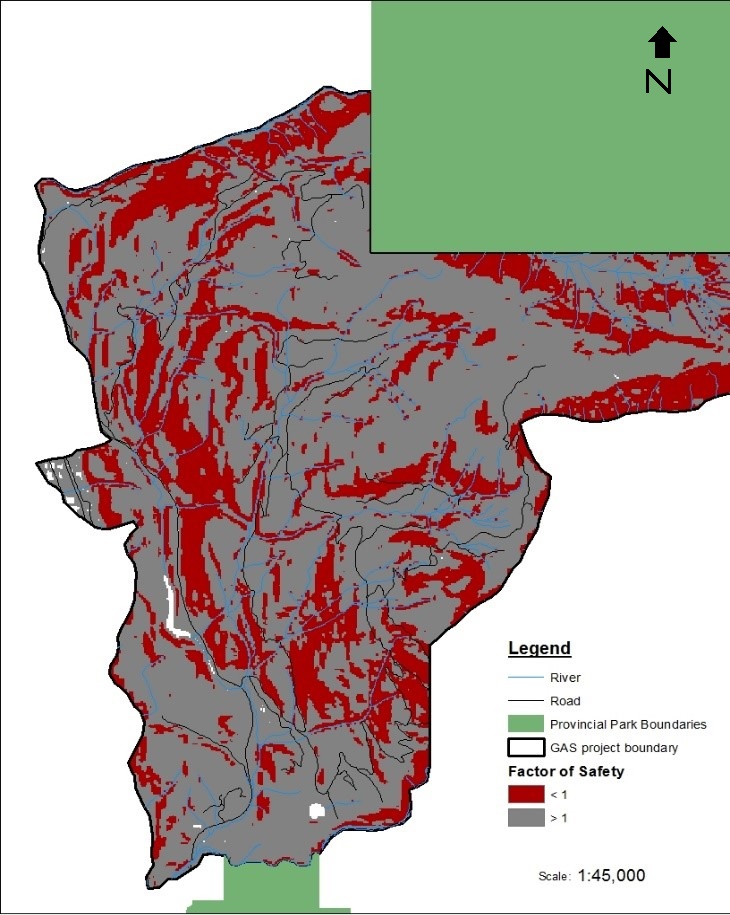
The provincial government of British Columbia (B.C) has recently granted an environmental approved for the Garibaldi at Squamish (GAS) ski resort project (Zeidler, 2016). This project has been a controversial debate amongst environmentalists and locals, and a detailed environmental impact assessment with 40 conditions attached have been issued to be completed by the proponents (Garibaldi at Squamish Inc.) as part of the approval certificate (Government of B.C, 2016). The study area is located approximately 15km north of Squamish on Brohm Ridge, adjacent to Mount Garibaldi and the Garibaldi Provincial Park. This region has a history of mass wasting events, such as the rockslide and debris flow at Mount Cayley in 1984, and Mount Meager in 2010 (Guthrie et al. 2012, Cruden & Lu, 1992). Therefore, it is necessary to determine if future developments are located within zones of potential landslides. This study uses a simple infinite slope model to access potential landslide areas, with the aid of GIS. In the absence of anthropogenic disturbance or geological faults, the relative stability of a slope is mostly controlled by local slope gradient and the degree of soil saturation. Future development within the project boundary should avoid areas with slopes of more than 40 o, in order to ensure any damage to infrastructure from mass wasting events. Road network that runs through unstable areas should have appropriate signage. It is not advisable for any development to remove mature vegetation (via clear-cut) from slopes with high gradients, as it would increase the slope’s susceptibility to landslides. Soil saturation has a great impact on soil stability. Therefore, it is important to prevent any changes that would induce saturation of steep slopes within the study area. Future development should avoid diverting surface drainage to gully heads or steep slopes, which will increase the probability of landslides due to the decrease in FS.
Full report: geob 406paper
presentation: Research Presentation