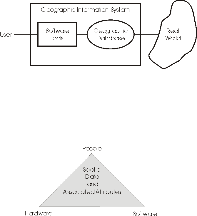
GIS as a combination of hardware and software that exist within a particular context.
The purpose of today’s lecture is to review your knowledge of “what is GIS”, and to review the different approaches people take to studying “GIS” [i.e., GI Systems, Science, and Society) by going through some of the different models and views that exist.
GISystems’ models range from the very simplistic through to the sophisticated (GIS can be deeply embedded within organizational structures). The aim of reviewing the various models is to reacquaint you with the concept — “what is a GISystem.” Each model can provide a different perspective into the GIScience issues that surround the use (and potential abuse) of geospatial technologies, and remind us of the complexities and uncertainties that every good GIS analyst should be aware of when using geospatial technologies and engaging others in society around the process and results of GIS analyses (i.e., GI Society).
It is assumed that you have taken Geography 270–Introduction to GIS, or an equivalent course. You should be familiar with the elements outlined in the Table of Contents of the free GIS text. The GIS: Tools for community mapping pages also provide a good introduction to GIS.
In each lecture note I will usually provide links to sites that supplement the material covered in the lecture. The additional readings generally offer a different take on the material presented in the text and, for some, may make it easier to comprehend the lectures / text / labs. For example, a range of experts have been writing and revising a comprehensive GI Science & Technology Body of Knowledge 2.0, which offers any number of discussions and interesting starting points for you to dip into when needed.
Learning Objectives
- Know why 'geography' matters;
- Understand the importance of GIScience;
- Recognize that 'GIS' has multiple meanings;
- Know something of the history of GIS.
Recommended Readings
Slides from the lecture are on Canvas.
Text: Chapter 1: Geographic Information: Science, Systems and Society.
Alternative text: GIS Basics: Chapter 1 Some find this the better introduction that the text's Chapter 1. (You only need to read one of these introductions, and this is probably the better one.)
A very interesting article on some of the social aspects of geospatial technologies. (self-driving cars)
An intro to GIS from the perspective of community mapping (For those in E&S, you should bookmark this site.) You don't need to read the material on this web site for this course--I just thought that it might show you how GIS is used by community groups in the real world.
A very useful text on GIS and the Social Sciences that provides many examples of applications (e.g., GIS and small-area estimation of income, well-being and happiness). (For those studying Human Geography and GIS, you should definitely bookmark this text.)
Here is a page that I have prepared that provides an overview of Python-related resources and some general comments on coding. When going through the lab it would be useful to be aware of the syntactical guidelines outlined here.
Additional Readings
Useful Resources
For those students interested in sustainable urban planning, the University of Twente has an open text on GIS in Sustainable Urban Planning and Management. In the text you will find several methodological demonstrations of the use of GIS in various cities around the world (includes data and an outline of the analysis conducted). (Those in the urban geography minor should bookmark this site.)
A video on the Canadian GIS (CGIS).
A periodical: Geospatial World.
One of the definitive articles speaking to concerns in today's lecture: Demystifying the Persistent Ambiguity of GIS as "Tool" Versus "Science"