Data
- Data List from the Geomatics at UBC site
- Data is also available on the Departmental Server drive G (for example, DEMs: G:\courses\data\DEMs).
- Natural Earth – free data for borders and other cultural and physical aspects of the world.
- Open data from the federal government of Canada.
- DataBC – open data from British Columbia.
- Metro Vancouver’s Open Data Portal
- TransLink Transit data is available on Abacus
- A note on BC_Assessment_data you can obtain from the UBC Library.
- For environmental data (e.g., pollution exposure) across Canada, check out CAREX
- OpenStreetMap Geofabrik – download regional extracts of all OpenStreetMap.org data.
- Another site that makes it easy to download OpenStreetMap data.
- A brief tutorial on various methods you can use to extract Open Street Map (OSM) data.
- A good resource from Carleton’s GIS Librarian on DEM formats (lists all the different formats DEM data might come in and how to read the data into ESRI products).
- Canada Census
- Statistics Canada — Boundary files (select the Cartographic Boundary files).
- Census attribute data from CHASS can be accessed through the UBC Library. You need to be logged onto the library system; click on Canadian Census Analyser to be forwarded to CHASS and access the data.
- Statistics Canada — Census (attributes) data Note that some files only contain Census Tract (CT) data, while other files contain Dissemination Areas (DA) data–you need to select the right files. You may need to download the IVT data and extract the data rather than the (for example) CSV files since I have found that in some instances the CSV files couldn’t be read properly by Excel. CHASS provides an alternative source for Census attribute data.
- An R package to download Statistics Canada data. A blog that discusses the R package.
- US Census — Several ways of accessing US Census data:
- NHGIS has convenient ways of navigating and downloading.
- Using R packages and scripts (mentions shapefiles and CSV files),
- Berkeley Library’s guide to Census data.
Open Educational Resources (OERs)
- Geospatial Analysis 6th Edition, 2021 update. A free online textbook – a textbook formatted as a website developed by some of the leading thinkers in the field.
- Fundamentals of Mapping – An Australian site, the Intergovernmental Committee on Surveying and Mapping provides “a comprehensive general overview of maps, mapping, cartography and map production.”
- Geographic Information Systems Basics – an open textbook from 2012.
- NCGIA Core Curriculum – an open resource on learning GIS from 1990.
- Here is the UBC LIbrary’s GIS Guide.
Free Training in the Basics
The below list is for those of you that did not take GEOS 270 or if you feel you need some background practice.
- Esri Virtual Campus – Free and paid courses. You need to set up a free account with ESRI.
- Start with Getting Started with GIS (for ArcGIS Pro).
- Learning ArcGIS (Pro) (free modules)
- A list of free training options oriented towards ArcGIS.
- ESRI Canada’s Education and Research page with links to learning resources.
- QGIS Documentation – links to the official documentation and training materials for QGIS.
- 12 Sites That Will Teach You Coding for Free
Software Resources
- How to obtain a student version of ArcGIS Pro
- GeoNet – a discussion board for ESRI products.
- GeoDa – GeoDa is a free and open source software tool that serves as an introduction to spatial data science. It is designed to facilitate new insights from data analysis by exploring and modeling spatial patterns.
- Open Basemaps for ArcMap – a package of some openly licensed and free basemap layers.
- GIS Services – the Library offers access to many different spatial and non-spatial databases, as well as a computer lab with ArcMap installed on the computers.
- QGIS Download – free and open source, download for Mac or Windows.
- GIS Stack Exchange – a very active forum for all technical GIS matters.
- For those looking at avalanches, slope stability and associated processes, check out this blog on ArcGIS Pro’s new surface analysis capabilities.
- Also, for those interested in doing projects in the U.S. on flooding, earthquakes and other hazards, check out Hazus from FEMA.
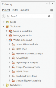
- For the geomorphologists among us, WhiteboxTools-ArcGIS is an amazing resource. You can easily add this python toolbox to ArcGIS Pro (just download, unzip and Add Toolbox to get hundreds of useful geomorphological routines ready to use:

Professional Networking
- Vancouver GIS Users Group
- GoGeomatics Jobs and Events
- ESRI maintains a student listserv for Canada: Students can subscribe to this list by sending an email to listserv@esri.com<mailto:listserv@esri.com> with SUBSCRIBE HED-CAN-STUDENT-L in the body of the email (no subject is required). Once added to the list, students can send a message to this list using the following email address: HED-CAN-STUDENT-L@atlantis.esri.com<mailto:HED-CAN-STUDENT-L@atlantis.esri.com>.
Further Training Options
Web Mapping Services
There are an increasing number of ‘web services’ available with which to add content to your maps. It is important to note that these services are only providing data for viewing, not for processing. That is, while you can display the data on a map, you cannot extract elements from the maps and process them (e.g., create buffers around features). As stated on the BC Government web site: “This service does not contain any functionality to extract vector based features from the BC Geographic Warehouse.”
ESRI Services:
BC Government:
- BC Government job advertisements — enter GIS as the keyword and click on Search.
- Geological maps of BC can be found here: MapPlace; Ministry of Energy and Mines.
Open Geospatial Consortium:
- USGS: List of OGC Web Mapping Services Available – Click on the ‘web site explaining the data’ link in order to get the URL you will need to connect to the map service.
Indices and other measures (ideas for use in projects!)
Some useful links to diversity and other indices that could be useful in a project. You can calculate various indices and map then in order to highlight areas of high (or low) diversity, using measures such as local Moran’s I. We explore the use of a simple index in Lab 1, looking at linguistic diversity in Edmonton and Vancouver.
Here is a paper (PDF) that provides ‘A review of methods for deriving an index for socioeconomic status in British Columbia‘ from a health services perspective. If you are looking into health-related issues you should look over this comprehensive review.
- https://en.wikipedia.org/wiki/Herfindahl_index While the wiki page talks about firms, when working with census data you would use % of different ethnic groups or % mother tongue, or any other grouping that you wish (that adds up to 100%).
- https://en.wikipedia.org/wiki/Diversity_index The Shannon index is a popular one–again, the p values would represent the proportions of people in different groups (the numbers should add up to 1).
- US Bureau of Labor Statistics: Location Quotients explained. This index allows you to compare the spatial distribution (clustering/dispersal) of a group in a census tract (for example), compared to the entire city or province (e.g., which census tracts have a greater proportion of recent immigrants, compared against all of the census tracts in the city).
Once you have created the indices, you can then explore the spatial nature of them (e.g., Are they clustered in certain areas? Do they display spatial autocorrelation?) using some of the tools available in the Spatial Statistics Tools toolbox
You should explore the tools, reading their help files in order to fully understand what the results are showing you, and build upon that knowledge.
Here is a detailed explanation of how to use the hydrology tools in ArcMap, written by GIll Green.