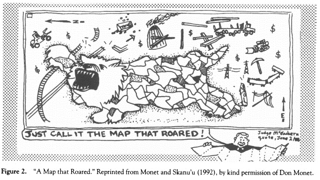
In an article called “A Map That Roared”, Sparke’s analyzes the statement that Judge McEachern made when examining a map that was created by the Gitxsan and Wet’swuet’en’s bands that detailed their remapping of their land that had been taken away from them during Canada’s colonization of First Nations land (and peoples). It was during a case where they were going up against the government for ownership claims and a notice of responsibility for the resources and land that was lost during the colonization of the area. Upon analysis of the map, Judge McEachern, the judge says “We’ll call it the map that roared!”
Sparke throws out a couple of ideas about what the interpretation could mean, such as a reference to a movie that is a satire of Cold War politics. His main interpretation is that the map ‘roaring’ is symbolic to the resistance that the First Nations were showing in their map. Since the map was going over the proposed areas that the law case was deciding, such as power lines, self-government areas, roads etc, the First Nations map was resisting the colonized restructing of their land. The colonizers who overtook First Nation land created their own type of maps and changed the landscapes. The map in question resisted that by displaying the effects that colonialism had on First Nations. The map refused the way that the colonizers wanted the land to be shaped.
The judge ended up denying the Gitxsan and Wet’swuet’en’s claim to ownership and failed to recognize the loss of resources and land that was forced upon these bands when colonizers took over the area.
Cartography and the world of maps, geography, and living things, points to how symbols of land, our land, whoever’s land, is important and symbolic and can have a great impact. As a geography student, I am constantly fascinated by maps and the importance of them. Maps can tell a story and map-making is not bias-free. Take our version of the world map for example. Is there a correlation between the fact that the countries in the Northern half of the map are traditionally the colonizers, and the bottom of the half is the half that is being colonized? Is it because the Northern half is represented as higher, therefore better? Yet colonization on the same half of the Earth occurs still. These are all questions that may be found in maps and the meanings that hide among them.
In my own hometown of Vernon BC, old maps label my area of town “Snob Hill”. Nowadays that would not be permitted but 100 years ago, it was an identifier.
The map that roared can be seen now as a bigger, wider symbol of a rebirth of resistance from First Nations, whether it is through Idle No More or the recent pipeline protests in BC and Alberta, more and more of Canadians are ‘roaring’ and it is about time that all of us roar.
I enjoyed reading your response Alyssa, thank you!
I am especially interested in your comment on the role maps play in colonizing processes and histories. In many ways the very act of mapping is an act of colonization–it is essentially dissecting land and attempting to fit it into a grid and into a language that can be read and analyzed. Mapping was of course an essential part of colonization in the last few centuries. Additionally it seems to me that, as useful as maps are, in many ways mapping degrades the land, a map takes something magical, beautiful, full, and real and attempts to define it with a few lines-land is compressed onto a piece of paper the way we UBC students are defined by an 8 digit student number.
Anyways, I was wondering what your thoughts are regarding changes to maps. Your interesting comment about the change of your neighborhood’s name makes me wonder-is the mutability of maps a strength or sign of the inherent weaknesses of mapping? What do you think about the change of your neighborhood’s name? What do you think it reflects about your town and the changes your town has gone through?
Thanks for the great read!
Interested in your thoughts,
Gretta
Thank you for your comment! I really enjoyed your analysis of it.
I think that the neighbourhood name change came around the time when Vernon became an “actual” town to the Province and had surveyors out here versus locals creating their own maps. I think it is a strength that maps can change because maps are subject to biases and if we can change them so they are better and more bias-free, then that’s good! 🙂 I think the name change reflects the population boom that Vernon underwent, suddenly there was many areas to the town and “snob hill” did not fit the area anymore with shifting demographics.
Thank you!
Hi Alyssa,
Great explanation of “The Map That Roared”! It’s really interesting to look at this from your geography-minded point of view. I especially like your ideas that symbols of land can have a big impact, and that map making is powerful story-telling. I guess in a similar way to historians deciding which events they include or exclude and how, map-makers shape the story of a place. There are some interesting thoughts in this article about Africa’s depiction on world maps, different than the usual opinions:
Danforth, Nick. “Every Map You’ve Ever Seen of Africa is Right.” Al Jazeera. 21 June 2015. Web. 22 June 2015. http://america.aljazeera.com/opinions/2015/6/every-map-youve-ever-seen-of-africa-is-right.html
I’m interested in your thoughts on this article, in the context of Indigenous peoples and settlers in Canada. What do you think of the author’s claim that “maps influence our view of the world, but our view of the world also influences how we see our maps. Meaning that the really important biases are often not on maps but in the heads of the people looking at them” (Danforth).
Thanks!
Kaitie
Hi! Thank you for your comments on my blog and the GREAT link you posted, I loved it! I will be sharing that with some geo-friends of mine for sure.
I think that the author is correct in stating that it is our own biases that are created culturally and exist in our own minds. Our own biases can create things out of nothing, not only making assumptions on land through map-making. When Canada was colonized, the thought of Aboriginal populations was not positive and that was reflected through maps that did not recognize Aboriginal territory or places of Aboriginal significance. Maps, in my opinion, simply reflect the views on land (or of people such as in the case of Canada), they do not create our views.
🙂
Hi Alyssa!
I really liked this quote from your post “The map that roared can be seen now as a bigger, wider symbol of a rebirth of resistance from First Nation” which was how I interpreted Sparke’s article as well. I think the word “roar” really represents the position and fight of the First Nations for their right to the land. And upon reading the article, it allowed me to develop such admirations for maps and be able to see how much of an impact they can really hold. I always just saw them as important for directions, but the kind of mapping from this article made me realize it holds so much more than that – history, trails, position, ownership, and how unique one map is from others depending on what stories they hold. Its cartography is so interesting, and your post articulated that for me, so thank you!
I wanted to hear your thoughts, since you mentioned “The colonizers who overtook First Nation land created their own type of maps and changed the landscapes.” And then how your hometown changed their label now from what it was a 100 years ago. With Google Earth now, do you ever believe that maps would be obsolete and overtime, it’ll be harder and harder to depict where history began? I imagine it’ll be just overlay with constant changes to cover up the histories of the early First Nations, which is definitely a terrifying and unjust possibility.
Thanks!
-Angela Olivares
Hi! Loved your comment, thank you for reading through my blog, it is very much appreciated. I think that because maps are always changing and fluid and can change things out, more local history will be ignored. History is not even currently depicted well on maps (or at all). Cartographers do not list sites of historical significance it seems that are not British or French. I do not think maps will become obsolete as they still serve the purpose of directions. I do think that more maps should be made marking areas of local, historical importance, and that if maps do not start to recognize those, those areas have the chance to become obsolete versus maps. It will be the areas of historical significance that will be impacted the most by not including them on maps, not maps themselves. I hope that was clear, I tend to ramble 🙂
🙂