Question 5
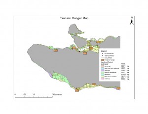
I was able to determine that roughly 8.25% of Vancouvers land area would be affected by a tsunami in this scenario. This was determined by calculating the total land area of Vancouver. Determined using the VancouverMask layer and using statistics to find the areas shape. Using the statistics on the affected areas layer I got the total area affected by the tsunami. Dividing these numbers got me the percentage of Vancouvers total land area affected.
Question 6
Schools Affected
Emily Carr Institute of Art and Design
Henry Hudson Elementary
False Creek Elementary
St Anthony of Padua
Ecole Rose des Vents
Healthcare Sites Affected
False Creek Residence
Villa Cathay Care Home
Yaletown House Society
I was able to determine the sites affected by selecting all the points of healthcare and education in Vancouver. Then using select by attribute, select by area. The area used to select the attributes was the affected landuse layer. I created a layer only using the points selected in the affected area. Opening the attribute table for these new layers I could see the names of each specific location.
