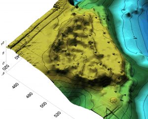
In preparing a paper about a waakyil patch Iain McKechnie reminded me of the outcomes of our mapping work. I include some of the images that project produced. But Iain also reminded me of how Teddy Gamble showed/taught him about wooms (devil’s club) after Teddy saw some of the bushes that were cut down before I intervened.
Iain also shared the following: “through the mapping and coring, and applying the GIS skills of Robert Gustas, the cultural deposits from Citeyats have approximately 12,000 cubic meters of ancestral harvesting labour represented which is a quite important for considering how many fish are potentially present in the site.”
Other colleagues, including Iain, have been working on documenting how these village sites are not simply the accumulations of waste materials -mere middens- but clearly built environment that have been engineered by our ancestors.  When we scrape off the foundation materials placed on the ground at Citeyats we find a wet swampy lower elevation site not really suitable for human habitation on the long haul. But the Citeyats we know today is dry, elevated, and set above the water level in ways that create a prime place for people.
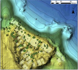
We also mapped the trees growing in the village. We recorded their ages and locations. We did this as it provided a unique graphical representation of the locations of house beams and posts from two centuries previously.
 The Green dots on the map represent trees; the bigger the dot, the older the tree.
Once we got past the issue of clearing the site we had a lot of fun with mapping and thinking about Gitxaała places in graphical ways.
