For the past three years I have been engaged in a coastal alpine project based in K’tai (on Pitt Island) within Laxyuup Gitxaała. Up until now these trips have all taken place between May and September. Much of what has motivate these trips has been a question about the possible – what might it take to move through and live within these places in ways that approximate the lives of our ancestors. This past week we extended our seasonal experience in the K’tai mountains and spent three days walking into the core area of our ongoing field research.
I’ve been blessed with great crew members on each of these forays into the K’tai.
- 2015: Jarek Ignas-Menzies, Cora den Hartigh, Knut Kitching, Alfred Larsen, Monica Nederend.
- 2016: Bryn Letham, Peter Merchant, Naomi Smethurst, Arron Trowbridge.
- 2017: Adam Huggins, Ada, Smith, Marion Travis
- 2018: Alyssa Bell, Tianna Sturdy, Ada Smith
I wasn’t certain that we would be able to even get part of the way in given the nature of our access route which is kind of like an ungroomed Grouse Grind with two lake crossings.
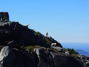
This field research is focussed on an area of Pitt Island accessed from the head of an inlet and takes us up to about 650m elevation. From there we have been establishing a base camp from which we conduct field studies between 650m and 1100m elevation – essentially the alpine ridges and peaks. To get there when there is no snow on the lower and mid elevations is tough but not impossible. My question was whether we would be able to do it with snow and sub-zero temperatures.
Flying into the trailhead I could see that some lower elevation lakes were frozen while others had clear water. But, it was not until we had made the 1.5km hike up to the first lake 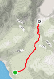 we knew the lake was frozen, but not enough to walk over. There was lots of open water along the creek mouth shoreline where we would have previously put our rafts in to paddle the 1.5 km length of the lake to the next trail head.
Our next problem was figuring out if we could actually walk around the lake. The northern shore of the lake was shorter in distance to our next trail head, but about a third of the way is a cliff face that cuts from the step slopes straight into the lake. We were pretty sure that wasn’t passible. The longer southern shore was also covered in fall downs, rock slides, and dense devil’s club thickets. Rather than lug our backpacks around only to find ourselves confronted by an impassible obstacle we decided to test the navigability of the shoreside. After tracking along for about a third of the way we decided that it was possible to get around. It was getting close to sundown so but rather than walk around the lake that afternoon we decided to pitch camp at the lakehead and work our way around it the following day.
The next morning we started picking our way around the lake, scrambling up and down the steep shoreline, at times on our hands and knees, over fallen trees, through thickets, and occasionally along animal trails that gave momentary hope that we had left the worst of it all behind.
The walk around the lake was about 2.3km. It took us an hour and a half to do. By now the sun was up. It was becoming a warm and beautiful sunny day. We took a break to have lunch in the sun, dry out some clothes, rest a bit, and just enjoy the viewpoint. The hardest hike was still ahead of us -2.5 to 3km with a 500m elevation gain.
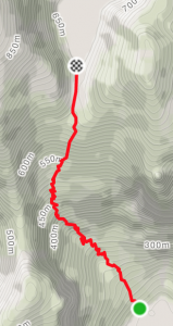
The hike up to the second lake took us two and three quarters hours. According to my GPS we clocked 3.2km. Between measurement error on the GPS, variations in specific path taken, I’ve found that this trail can measure out anywhere between 2.5 and 3.5 km.
There was only a dusting of snow at the start of this trail. By the time we reached about the 350m elevation mark we had a couple of inches and by around 400m no denying that we were walking in snow. The top section from around 500m elevation had accumulations of between 30cm and 1m of snow making the hike up just that much more ‘interesting.’ The last couple of hundred meters of this trail follows a buried creek in a sharp little ravine. When clear of snow we simply jump from rock to rock walking along an essentially level, but moss covered rocky trench. The snow cover made this section more difficult than I had previously experienced it.
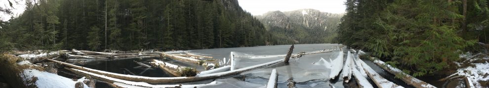
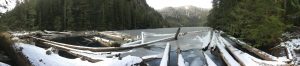
We were happy to see solid ice across the second lake when we came out of the trail – but before making our way to the lake we had a steep slope (almost vertical) of about 10 meters elevation that we had to scramble up through the loosely consolidated snow.
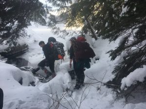
Photo: Ada Smith
Once standing in front of the lake shore we dropped packs and I went down to the lake to check the thickness. Using a small axe I cut in to find that the ice was more than 8 inches deep. Okay, we were free to head over the lake to the other end where a hunter’s cabin is located – though we weren’t sure what state it might be in with all the snow at that level.
Our crossing of the lake was interrupted by coming into a patch of slush over the lake about 6 inches deep or so.
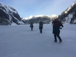
Photo: Ada Smith
Given the time of day (4pm) and the uncertainty of the state of the cabin, plus the worrisome condition of the ice, we turned around to go back to where the trail had come out at the lake.
We set up camp deciding to wait until the next morning to check the conditions of the lake and, weather permitting, head across the lake. Far better to do this at the start of the day than to race against a setting sun in sub-zero temperatures.
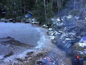
The camp site at the western end of the lake is an amazing place – summer and winter. Two years previously Bryn Letham, Naomi Smethurst, and I spent several nights camped there when we had no way to paddle over the lake. On that previous trip we had climbed the adjoining ridges (to north and then south) to work our way round this lake and the third one a bit further to the east. As part of our camp we had built a small lean-to for rain shelter.
After setting up our tents we got a fire going and started preparing supper. We made use of the poles from the old lean-to to cut up for firewood and soon had a cheery blaze going.
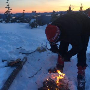
Photo: Ada Smith
For my part I was so cold that I had to escape to my tent for the night. My crew very kindly brought my supper to the tent!
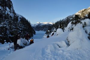
Photo: Tianna Sturdy
The overnight temperature dropped to around -10C.
About 4 to 6 inches of snow fell over night. It was a beautiful sight to wake up to, but the accumulated snowfall combined with a northerly wind and continued light snow made me reconsider going any further. If I knew that I could rely upon the cabin on the far side of the lake I knew that we would be able to dry out any of the wet gear we had (or mostly I had!) accumulated. This was important. But, if the cabin was damaged from the snow (it’s a decades old cabin) or buried by snow accumulation that would make the cabin unusable. Rather than taking the risk to check out the cabin I decided that it would be best for us to head back down toward sea level where there was less snow and at the very least better shelter opportunities.
We broke camp, suited up, and headed back down the hill retracing our steps. The entire trek down took about four and a half hours – not too bad. By the time we were down the sun had come out and a strong nor-westerly breeze was blowing into the inlet. I had hoped we might be able to work our way to a nearby cabin (about a kilometre away, but the tide was up making walking out of the question and the wind was too strong to effectively use our packrafts. So we got ready to spend the night at the trailhead.
While we were doing that I sent a message via our satellite communicator to Ocean Pacific Air, our charter service, to ask if they could pick us up that afternoon of the next morning. Within minutes they had responded saying they would be there within the hour. Good thing too, as the following day turned out to be a big storm which would have left us on sight for a day or two more.
The experience trying this route in February gives a nice insight to the knowledge and equipment that our ancestors would have needed in order to navigate through these places. It humbles one to consider how, what for us today is often a rare expedition, was to them just part of a normal day.
[Note: all photos, unless otherwise indicated, by Charles Menzies.]