For our final project, we did a GIS analysis to find the best areas in Greater Vancouver to make an orienteering map of. Orienteering is a competitive sport where participants navigate between checkpoints in diverse terrain (in this case, parks or forests) at running speeds, using a map and compass. As a 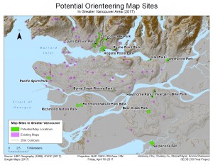 competitive orienteer and member of the Greater Vancouver Orienteering Club, this project was super exciting to me! Our analysis was based on park type, accessibility by roads and transit, not being at the same location as an existing map, and area size. We found data from the UBC Geography G:Drive and a couple online sources, imported it into ArcGIS and performed a variety of analyses to narrow it down to 14 potential areas. These areas were all large, accessible park areas that had not yet been mapped. We summarized our findings in this map , this report, and this flowchart. We also included some maps of the steps we took to get to our final map: 1 2 3 4 5 6 7 8 9.
Initially, I was concerned about this being a group project because I expected complications with sharing versions of files or having disagreements about what steps to take or creative processes. Luckily, none of these turned out to be issues and it turned out to be quite beneficial to have multiple group members. We ended up all working on map and analysis in ArcGIS together, on one group member’s account. This was good because often we wouldn’t all know what the next step to take was, how to add a layer, how to use a certain tool or some other challenge, but a different group member would. We all had different strengths such as problem-solving, technology, logic, or being able to explain things well which ended up allowing us to be able to figure out the vast majority of the difficulties with the project on our own. Since we all had worked on it together and so all knew the steps we took and why, we could divide up the written report fairly equally write our own parts, and then read through and check others for errors or omissions. While some people did end up writing larger parts then others, I believe it was still close to as fair as it could have been.
I learned a lot during this project! I learned some new GIS skills, such as how to combine adjacent polygons into just one polygon so that you can calculate their area as a single object. I also learned how to properly save the layers we made so we didn’t have to redo everything we’d done last time, like I’d done twice in lab 5! It was also interesting to be able to see how the knowledge I’d learned in the GEOB 372 cartography class this semester helped me with the GEOB 270 class. I hadn’t realized how much more the other group mate who had taken 372 and I knew about map design then our peers. On the other hand, several of the people I was working with were a lot quicker at finding and doing easier commands such as clips and buffers, or better at managing the database, then I was. This was honestly one of the first group projects I’ve done where every person made a very positive impact on the project.
As a follow-up, I sent our final map to one of the Greater Vancouver Orienteering Club executives. He said he is going to check the areas out by satellite imagery or in person, and then make a new orienteering map for a competition in the future if any of them work out. I’d likely race in the competition. It’s super cool to see how the things we learn in class can actually have direct applications for things in my person life and potentially result in real changes.