Riparian
Introduction:
The purpose of the following assignment is to introduce definitions and concepts within the profession to a non-expert technical audience through a series of definitions (e.g., scenarios, parentheses, sentences, and extended definitions). The assignment also uses graphics, images, and examples to depict the meaning of the term, which enriches the way the definition is developed and used in the relevant profession.
Reading Situation / Audience:
The following terms are described for students and instructors in the ENGL 301 Technical Writing course who have a general knowledge of the environment and are able to make approximate identifications of topographic features. To understand a riverbank in detail, they need to know what it is, its importance, how it is formed, and what function it serves.
Parenthetical Definition:
Lands that occur along watercourses and water bodies.
Sentence Definition:
Riparian areas are those lands bordering streams, rivers, and lakes that are the intersection of terrestrial and aquatic ecosystems.
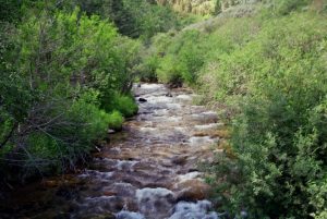
Fig. 1: A Healthy riparian area on Montana ranch
Expanded Definition:
1. Location of Riparian
Riparian areas are plant communities adjacent to and influenced by the surface and subsurface hydrologic features of perennial or intermittent torrent and stagnant water bodies (rivers, streams, lakes, or drainages). Typically, riparian areas are characterized by one or both of the following features:
- Nutrient species that are distinctly different from their neighbors, and
- Species that are similar to their neighbors but exhibit more vigorous or robust forms of growth.
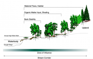
Fig. 2: Schematic of a generic riparian area
Fig.3 shows the vertical (upstream-downstream), vertical (interstitial), and horizontal (floodplain) dimensions that interact hydrologically and ecologically. Riparian areas include the channel system(shown as part 1 on Fig.3), the floodplain(shown as part 2 on Fig.3), and the transition zone(shown as part 3 on Fig.3) into the uplands. The alluvial aquifer(shown as part 4 on Fig.3) is located below the river channel and includes a subduction zone and a deeper groundwater dive zone. The subduction zone(shown as part 5 on Fig.3) contains groundwater that has not been in contact with or mixed with surface sources for a long period of time (usually hundreds of years or more). In contrast, in the subduction zone, river water moves rapidly through the surface alluvium at very high hydraulic conductivity.
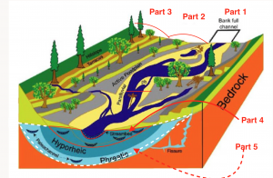
Fig. 3: Ideal model of an alluvial river corridor
2. Characteristics of Riparian
Riparian areas are usually intermediate between wetlands and uplands, and their components are usually:
- Vegetation
Species and amounts differ from adjacent upland vegetation because more water is provided to the plants from the associated watercourse or water body. - Soils
Soils in natural riparian areas consist of layered sediments of different textures that are subject to intermittent flooding or fluctuating groundwater levels that may reach the surface. The duration of soil wetting depends on the water level of the adjacent water bodies. - Water
Riparian areas are directly influenced by water from watercourses or water bodies. They are located along natural watercourses or near natural lakes and artificial water bodies such as ditches, canals, ponds and reservoirs.
3. Riparian Features
Riparian zones function in different ways in various ecosystems. Despite the differences, all riparian areas share some similar ecological features that give riparian areas a unique value relative to the surrounding landscape and ecological space.
- Hydrology Function
Riverbanks influence water flow by shaping soil development and vegetation growth. - Nutrient Cycling
Nutrients (e.g., nitrogen, phosphorus, calcium, magnesium, and potassium) are taken up by shallow-rooted riparian vegetation. Dissolved nutrients that move with groundwater and leached nutrients from the soil may be taken up by deep-rooted riparian vegetation. Some nutrients pass through without being retained, while some nutrients absorbed by riparian vegetation may be reintroduced into the water column as the vegetation dies and decomposes. - Flood reduction
As floodwaters flow through vegetated areas, riparian plant roots resist the flow and dissipate energy, thereby increasing the time for water to infiltrate into the soil and be stored for plant use. - Water purification
Sediment is trapped by plant roots, thus reducing the number of suspended solids in the river enhancing water quality. - Enhances biodiversity
Riparian ecosystems provide food, energy, and shelter for both terrestrial and aquatic ecosystems. And the linear nature of riparian ecosystems provides unique corridors that are essential to serving as migration and dispersal routes and forest connectors between wildlife habitats.
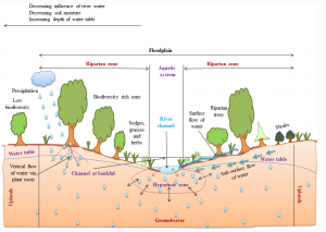
Fig. 4: A typical riparian zone with its distinguished features
4. Disturbance to Riparian
Erosion and sedimentation caused by flooding are common forces that shape riparian areas. During extreme floods, these forces can sometimes appear destructive, but in most cases, riparian areas recover quickly. On the other hand, changes that people make often have long-term adverse effects on riparian areas. Cross-channel damming, diking, and channelization may have the most detrimental effects. These modifications significantly alter the movement and storage of water that is important to riparian systems. Withdrawal of water from streams may also reduce baseflow and thus deprive riparian areas of water.
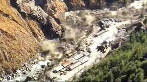
Fig. 5:Floods that was breaking the rriparian in India on February 7, 2021
The most common disturbances to riparian areas include the removal of the vegetation and conversion of the area to other uses (e.g. farmland and urban land). Over-harvesting strips vegetation, while overgrazing concentrates livestock in riparian areas for long periods of time, reducing vegetation and trampling stream banks. The development of real estate can destroy natural plant diversity and structure, which lead to soil consolidation, erosion, and disturb wildlife. Invasive plants which take advantage of good growing conditions in wet sites often invade these areas. The dominance of these plants among native plants leads to a decline in biodiversity, which is harmful to the habitat of most wildlife species.
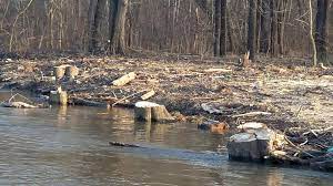
Fig. 6: Over-harvested riparian zones
Reference
Bonnie, L. I., Elon, S. V., & Brian, J. P. (2000). Defining Riparian Areas. G. W. Robert, & M. H. John, Forestry and the Riparian Zone .
Rinku Singh, A. K. (2021, January 03). Managing riparian zones for river health improvement: an integrated approach. Photosynthesis Research, pp. 195–223.
National Research Council. (2002). Riparian Areas: Functions and Strategies for Management (2002). Washington, DC: The National Academies Press.
USDA. (2020, October). Riparian Areas Environmental Uniqueness, Functions, and Values. Retrieved from United States Department of Agriculture: https://www.nrcs.usda.gov/wps/portal/nrcs/detail/national/technical/?cid=nrcs143_014199
Wyoming Department of Environmental Quality. (2020, September). Why are Riparian Areas Important? Retrieved from Wyoming Game and Fish Department Riparian Information: http://deq.wyoming.gov/wqd/non-point-source/resources/why-are-riparian-areas-important/
Leave a Reply