Mangroves, which are trees that grow in the brackish water of coastal zones, create a transitional area between land and sea. They are a seemingly resilient species given their architecture, strength, and adaptations to sea level rise, but have been subject to decline in recent years. These tropical forests perform various ecosystem services including sheltering coastal communities from hurricanes and providing nurseries, feeding grounds, and critical habitats for various aquatic and terrestrial species. In addition, mangroves have an influence on a global scale as allies in the combat against climate change. They are among the most productive ecosystems per unit area, and can sequester in excess of 1,500 mg carbon/na in their soil! This makes them efficient in mitigating the impact of increased fossil fuel emissions.
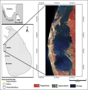
Unfortunately, the Anthropocene era has marked a tremendous loss for these forests. In Sri Lanka, the 1700 km coastline, which is comprised of lagoons and sheltered bays, are prime sites for aquaculture development. A recent article found that more than 50% of Sri Lanka’s green barriers have been lost to short-term profit at the expense of long-term productivity. The landscape in these coastal communities has dramatically changed in the last three decades due to the expansion of shrimp aquaculture and the conversion of mangrove forests to coconut groves. Aerial and satellite photos taken in 1992/1994, 2007, and 2012 of Puttalam Lagoon found that shrimp farms increased by 2777% over this 19 year period with mangroves declining by 34% and coconut groves increasing by 17%. The environmental loss corresponded to an estimated net carbon loss of 191 584 tC – making a total of 75.5% of the total carbon.
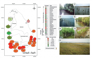
Following the devastating 2004 tsunami in the Indian Ocean, residents of Sri Lanka became aware of the vulnerability of these forests and set in motion numerous restoration projects. Warnakulassooriya Noel Douglas Thisera also known as the “Kadolana Master”, which means “The Leader Who Protects the Mangrove,” saw the value of these ecosystems through his fishing practice. For the last 16 years, the “Kadolana Master” and his community have planted over 2 million saplings and have dedicated all their efforts to restoring the mangroves. Although this conservation project was successful in his community, this was not the case for many other Sri Lankan projects. Other projects failed because they focused on the rapid re-planting of trees without proper technical knowledge or community engagement. In 2017, a study revealed that out of 1,000 – 1,200 hectares of restoration, only 200 – 220 hectares were successful. Out of the 23 planting sites, the seedlings died due to wrong location, wrong species planted, and an absence of monitoring post-planting.
There is a lesson to be learned here. Not all members of a community can be “Masters” in conservation. In order for conservation to be successful, there are certain factors required – scientific knowledge, local knowledge, and community engagement. In many cases, conservation projects fail because this balance is not met. In order for conservation projects to be successful in sustaining livelihoods and allowing for long-term survivorship, involvement across the three sectors is key! For more updates on ocean conservation, follow #OceanConsvnUBC.