Monthly Archives: October 2017

Do you like the dairy products of Hokkaido?

Why do we like Japan?

Why do we like Japan? Why would people all around the world like to travel to Japan? There are a lot of reasons. For example, beautiful natural sceneries, iconic fashion style, attractive history and kind people. An essential point, in my opinion, is food. I like the food of Japan. I am a crazy fan of Ramen and fried food. The good news for me is that the exchange rate of Yen to Canadian dollar decreased after Abe was reappointed so that I could do shopping on Japan’s shopping website. When I was browsing that website, I noticed that the external packings have the wold “北海道産” for a lot of dairy products, such as Shiroi Koibito cookies, the Royce chocolates, milk pudding and ice creams. Additionally, the dairy products with “北海道産” are very popular and top-rated on many shopping websites (on Amazon also).

https://shop.r10s.jp/hokkaido-omiyage/cabinet/koibito/isiya005-pac01.jpg

http://i.ebayimg.com/images/i/171321318208-0-1/s-l1000.jpg

http://danielfooddiary.com/wp-content/uploads/2015/09/hokkaidomilk3.jpg

https://image.rakuten.co.jp/onakaegg/cabinet/gift/milkgift/nyu_gift_1.jpg

https://www.hokunyu.jp/en/common/images/effort/effort_lead_txt01.png

Some comments from Amazon of Shiro Koibito.

Why Hokkaido?

According to Karan (2005), initially, Hokkaido located in the North of Japan and it is the second largest island of Japan (the first is Honshu). Approximately Hokkaido is in the sub-cold zone which between north latitude 40 degrees to 45 degrees barely free from typhoon and moldy. Moreover, contrasting other crowded places of Japan, Hokkaido owns a quarter agricultural land in Japan. Furthermore, Hokkaido has a volcanic belt, the deposition of volcanic ash after volcanic eruptions makes the soil became fertilized. Additionally, the west of the Hokkaido is the sea of Japan, the southeast of it is the Pacific Ocean, and the northeast is the sea of Okhotsk. Under the influence of the ocean, the most islands of Hokkaido has the temperate oceanic climate or sub-cold zone oceanic climate. These reasons make Hokkaido become the important agricultural base of Japan. Wheat, potatoes, and dairy production ranked the first of Japan.

https://upload.wikimedia.org/wikipedia/commons/thumb/b/bc/Regions_and_Prefectures_of_Japan_2.svg/1200px-Regions_and_Prefectures_of_Japan_2.svg.png

Hokkaido and Europe

There are 14 sub-prefectures of Hokkaido, the cold weather of Kushiro sub-prefecture, Nemuro sub-prefecture and Soya sub-prefecture is not capable of carrying out agricultural activities. However, These three sub-prefectures are the most abundant dairy industry over the whole country. We all know that the stock farming in Europe is well developed and organized. Comparing Europe farm and Japan farm, they have four crucial points in the same. First, they have the similar oceanic climate, which is not so cold in the winter and not so hot in the summer. It also has an evenly year precipitation, no drought water-logging, which is suitable for pasture growth, and for the development of stock farming. Second, they all have a significant proportion of plains with fertile earth. Third, they all have dense river network with short rivers originated from mountains which provides irrigation. Finally, Japan and many European countries are developed countries with the higher technical management of stock farming. Overall, accompanying the excellent natural condition and acquired development, the dairy productions of Hokkaido become very famous around the world.

http://www.travel-around-japan.com/map-k11-hokkaido-pref.png

https://upload.wikimedia.org/wikipedia/commons/thumb/2/2e/Hokkaidomap-en.png/722px-Hokkaidomap-en.png

http://footage.framepool.com/shotimg/qf/408859065-tsurui-cow-herd-grazing-pasture.jpg

https://www.jnto.go.jp/eng/wp-content/uploads/2016/06/gr43_07.jpg

Conclusion

However, I am also considering the different eating habits between Asian and European, specifically the East Asia and the Europe. The dietary structure of the East Asia is mainly herbivorous, while in Europe is the carnivore. At first, Hokkaido had barely any stock farming. Because some places are too cold to grow plants, the Japan government started to develop stock farming in those areas instead of planting. This is a good choice since Kushiro sub-prefecture, Nemuro sub-prefecture and Soya sub-prefecture are with particularly favorable natural conditions of stock farming. On the other hand, the dairy production also brings effective economy profits to Japan, especially in tourism. People who travel to Japan would consume those dairy productions for themselves or as the gifts for their families and friends. Therefore, nonetheless herbivorous or carnivore, it is important to adjust measures to local conditions. Besides, I love the winter of Hokkaido and its snow. One of my friend who is from the north of China always makes the joke on me: “It is not exciting when there is snow. It is only excited for you and other southern guys.”

https://jtb.com.sg/wp-content/uploads/2017/05/Day-3.png

http://hana3939.com/wp-content/uploads/2014/03/213e5aa1ad298eb0be26f0db2805782e.jpg


Reference

P.P. Karan (2005) Japan in the 21st Century: Environment, Economy and Society, Lexington, The University Press of Kentucky.


Tokyo 2020 Natural Disaster Prevention

Introduction

Our group did the research of natural disaster prevention strategies of Tokyo 2020 through four aspects, early warning systems, prevention procedures, evacuation, and post-disaster management. The 32nd Summer Olympic Games and the 16th Summer Paralympic will be held in Tokyo, from July 24th to August 9th, 2020 and August 25th to September 6th, 2020 respectively (Tokyo2020).

https://upload.wikimedia.org/wikipedia/commons/thumb/f/f2/Tokyo_2020_Olympics_logo.svg/1200px-Tokyo_2020_Olympics_logo.svg.png

https://upload.wikimedia.org/wikipedia/commons/thumb/b/bb/New_2020_Summer_Paralympics_Emblem.svg/1200px-New_2020_Summer_Paralympics_Emblem.svg.png


Brief Introduction of Our Projection

Initially, Tokyo is a coastal city. It is located in the southern part of the

Kanto plain in Honshu with a large population (Karan, 2005). It is also situated on the boundary of Eurasian plate and the Pacific plate (Karan, 2005). These two reasons make Tokyo prone to several disasters, such as earthquakes, tsunamis, as well as volcanic eruptions (Ministry of Finance Japan, 2017).

Early Warning System

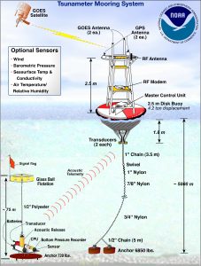
The Japan has Early Warning System (EWS) of earthquake reporting, which is provided by the Japan Meteorological Agency (JMA). It collects seismic data from a network of over one thousand seismographs nationwide and provides estimates of seismic intensities along with a rough arrival time o the principal motion. Deep-Ocean Assessment and Reporting Tsunami (DART) monitors tsunami, which developed by the National Oceanic and Atmospheric Administration (NOAA) in the United-States. It comprised of over thirty-nine buoy-mounted detection systems, measures ocean pressure in tandem with sea-surface height estimates to provide advanced warnings on developing tsunamis.

http://www.noaanews.noaa.gov/stories2005/images/tsunami-dart-system.jpg

Evacuation

Japan has devised the Basic Plan for the Promotion of Tokyo Inland Earthquake Emergency Countermeasures (the TIE Basic Plan) by The Tokyo Metropolitan Government (TMG), which calls for the construction of systems to ensure the sustaining of the pivotal functions of the central government and the building of earthquake resilient communities.

Post-Disaster Management

The Japanese government has established an Earthquake Insurance System in 1966 for indemnifying natural disasters such as earthquakes and tsunamis, as well as the volcanic eruptions (Ministry of Finance Japan, 2017). There are three approaches of post-management in Japan: self-rescue, government assistance, and social relief.

Conclusion

Japan has detailed and well-organized early warning system, evacuation and post-disaster management strategies for coping with natural disasters. However, due to the increase in people amount in and around Tokyo. the government needs to and has to put the large effort into disasters prevention.

https://ichef-1.bbci.co.uk/news/624/cpsprodpb/4ADB/production/_87336191_6ff6e307-9a72-4ab8-8096-05f77ec04e95.jpg


Weaknesses and Concerns    

The Kantō Great Earthquake of 1923 (the magnitude of 7.9) brought a painful lesson to the Japanese nation and gave Japan’s disaster prevention work a profound impact. Therefore, in the later disasters prevention plan, Japan paid a special attention to the establishment of urban shelters, fire belt construction around rivers and parks, the community disaster prevention base planning, which gradually formed a relatively integrated and well-organized disasters prevention system.

http://devastatingdisasters.com/wp-content/uploads/2015/04/the-great-kanto-earthquake-1923.jpg

Until 2016, The population of Tokyo had an estimated population of 9262.046 in 2,191 square kilometers (Tokyo proportion) which Tokyo is in high population and high population density. Moreover, Japan has an average of four earthquakes per day. However, my concern is that How would those disasters prevention systems work during the Paralympic? The public attention of the Paralympic Games may not be as high as the Olympics. But it is certain that the number of tented people around Tokyo and in Tokyo will still increase, and the hardest and most important thing, how to ensure the safe evacuation of the Paralympic athletes if any natural disaster happens during the Paralympic? Those physically or mentally disabled people even need assistance in their daily life. Additionally, the disasters prevention system still has drawbacks, which may not alarm in time.

According to the Basic Plan for the Promotion of Tokyo Inland Earthquake Emergency Countermeasures, the Japan government is increasing the existing emergency response structures in order to fit Games. If any natural disaster happens, all people in the Tokyo stadium will evacuate to the nearest shelter. This means, the Japanese government need to and has to be fully prepared before the start of the Paralympic and promote disasters prevention knowledge to all participants and athletes of the Paralympic.

Fortunately, Japan has rich practiced experience and matured disaster prevention system. Before the Games, people can go to the website: http://www.mlit.go.jp/river/bousai/olympic/en/index.html, to find any disasters prevention information. I wish both the Games a complete success.

https://tokyo2020.jp/en/assets/upload/20170925-1000daystogo-top-sp.jpg


Reference

Japan Meteorological Agency. Earthquake Early Warning System, 2017, Retrieved from:

      http://www.jma.go.jp/jma/en/Activities/eew.html .

Ministry of Finance Japan. (2017). Outline of Japan’s Earthquake Insurance System.

     Retrieved from: http://www.mof.go.jp/english/financial_system/

     earthquake_insurance/outline_of_earthquake _insurance.html

National Oceanic and Atmospheric Administration. Deep-ocean Assessment and

     Reporting of Tsunamis (DART) Description, 2017. Retrieved from: http://

     www.ndbc.noaa.gov/dart/dart.shtml

P.P. Karan (2005) Japan in the 21st Century: Environment, Economy and Society,

     Lexington, The University Press of Kentucky.

The Scenerio-Based Plan for a Large-Scale Earthquake in Tokyo Metropolitan Area.

      (2013). Asia-Pacific Economic Cooperation. Retrieved from: http://www.apec-

     epwg.org/public/uploadfile/act/13_epwg_sdmof_007.pdf

Tokyo 2020 Overview Outline of the Organizational Plan and Tokyo 2020 Paralympic

     Games. Tokyo2020. Retrieved from: https://tokyo2020.jp/en/games/plan/

Japan – A desirable and travelling place


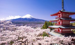
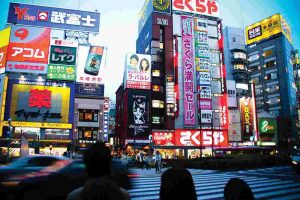
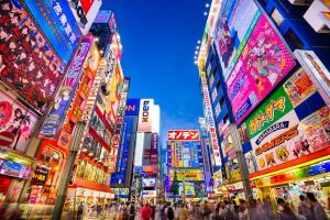
When talking about Japan, the first thing come to my mind is “someday I will travel to there.” Yes, Japan is a great tourist country, Mount Fuji, cherry blossom, temple and shrine, Shibuya, and many places are full of charm and very attractive to tourists. In this blog, I will briefly discuss one or two interesting tourist places associated with geographical knowledge.


An introduction of Japan tourism resources

Japan’s tourism resources are mainly in two aspects. One is the beautiful physical sceneries of the islands, rivers and mountains, waterfalls and deep valleys, and hot springs, etc.. For example, Mount Fuji, Matsushima, and Miyajima. These natural sceneries have very good and special features and are in good states for tourism. Second, the rich and colorful historical and cultural heritage, especially in Nara, Kyoto, and Kamakura. Japan not only retains its national tradition but also actively absorbing the foreign culture, committed to modernization. Tokyo is one of the largest and most modern cities in the world. In addition to Tokyo, Osaka, Japan’s famous tourist city with historical and cultural characteristics. Yokohama is known as the “world kitchen.” Kobe is a city combine eastern and western cultures that is called “the Japanese spiritual hometown.”

http://japan-magazine.jnto.go.jp/jnto2wm/wp-content/uploads/1608_special_TOTO_main.jpg

http://us.jnto.go.jp/images/japan101.jpg

https://www.intrepidtravel.com/sites/intrepid/files/styles/low-quality/public/elements/product/hero/japan_tokyo_fluro-advertising-on-buildings.jpg

https://media.boingboing.net/wp-content/uploads/2016/03/japan.jpg


Mount Fuji 富士山

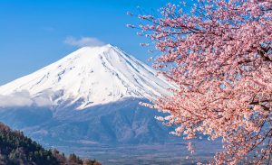
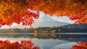
Mount Fuji is the highest peak of Japan, and it is one of Japan’s crucial national symbol. Mount Fuji is one of the world’s largest active volcanoes across Shizuoka and Yamanashi, which closes to the Pacific coast, about 80 km southwest of Tokyo. Even though Mount Fuji is an active volcano, it is currently in the dormant condition, but geologists still put it in the active volcanoes list. Since the year of 781, a total of 18 eruptions were recorded, the last eruption in the year of 1707 which was in the Edo period. This last eruption had a lot of words and pictures records. August 2002 (Heisei 14 years), the Japanese Land and Geography Institute re-measured the height of Mount Fuji, which was 3775.63 meters high.

Mount Fuji is more than 60 million years old volcano, and the past was the island of the Izu peninsula,  which is due to the tectonic activity of the Eurasian plate and the Pacific plate. The intense collision of Izu peninsula and Honshu island uplifted the mountains and made a basic formation of Mount Fuji. The Foothills of Mount Fuji is about 125km long; the bottom diameter is about 40 ~ 50km. Crater surface diameter is about 500 meters, and 250 meters deep.

Mount Fuji is a typical stratovolcano. It has the standard cone-shape with unique and beautiful contours. Although Mount Fuji is in a dormant state, there is still the jet phenomenon. The base of Mount Fuji is a Tertiary stratum. At the beginning of the Quaternary, volcanic lava broke through the Tertiary strata, erupted and accumulated during that period. After several eruptions, volcanic eruption layer kept accumulating, and finally became a cone-shaped volcano, Mount Fuji. Volcanic activities also bring a wealth of geothermal resources to Japan. All kinds of hot springs are all over the country. Hot spring travel is one of the most popular recreational activities in Japan. It is said that Japan has more than two thousand hot springs, Japanese-style hotels have their hot springs. In Japanese, if people need to say hiragana “fu(),” they usually would say “the ‘fu’ of Fuji San (ふじさん).

https://www.jtbgenesis.com/pic/tour/20171231_MT.FUJI.jpg

http://www.planetware.com/photos-large/JPN/japan-mt-fuji-and-cherry-blossoms.jpg

https://www.japantimes.co.jp/wp-content/uploads/2017/02/n-mountfuji-a-20170216.jpg

http://i.imgur.com/J0alCuJ.jpg


Kyoto 京都

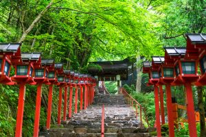
Kyoto is located in the Kansai area which is the center of the Japanese archipelago. Kyoto was built in the year of 794 as the capital of Japan, that has been a thousand years of history. Kyoto is the home of the Japanese spirit, Japanese textiles, ceramics, lacquerware, dyeing fabrics and other traditional crafts. Meanwhile, it has the Japanese Sado and Japanese Ikebana. Kyoto as the cradle of Japanese culture, art, Buddhism, and Shinto sanctuary, also known as “true Japan.” There are hundreds of famous shrines and temples, with more than two percent of Japan’s cultural heritage resources. Beautiful natural sceneries and a long history of building and architecture, attracting countless tourists come to sightseeing. Kyoto is a museum of ancient architecture of Japan. In 1994, the ancient capital of the historical buildings of Kyoto as a cultural heritage by the UNESCO World Heritage Committee included in the “World Heritage List.”

http://static5.businessinsider.com/image/5818c9bbdd08956c5a8b47b1/19-photos-that-show-why-kyoto-and-tokyo-were-voted-the-best-cities-in-the-world.jpg

https://fastjapan.com/en/wp-content/uploads/2016/11/kyoto.jpg

http://www.getsready.com/wp-content/uploads/2016/09/wonderful-scenery-in-kyoto.jpg

https://thumbs-prod.si-cdn.com/PVO4sJKnLQRv483AnxqMh97JdAE=/fit-in/1072x0/https://public-media.smithsonianmag.com/filer/My-Town-Kyoto-Japan-geisha-district-1.jpg


References

Horinaga 4th (1707) Eruption, Available                                from: http://sk01.ed.shizuoka.ac.jp/koyama/public_html/Fuji/fujid/1707.html

Japan Guide of Kyoto, Available from: https://www.japan-guide.com/e/e2158.html

Japan Guide of Mount Fuji, Available from: https://www.japan-guide.com/e/e2172.html

Kyoto Prefecture Web Site, Available from: http://www.pref.kyoto.jp/error404.html

Kyoto Wikipedia, Available from: https://en.wikipedia.org/wiki/Kyoto#Geography

Mount Fuji Wikipedia, Available from: https://en.wikipedia.org/wiki/Mount_Fuji#Geography

P.P. Karan (2005) Japan in the 21st Century: Environment, Economy and Society, Lexington, The University Press of Kentucky.