My graduate research, supervised by Dr. Mathieu Bourbonnais, comprised of two chapters:
- Modelling spatiotemporal changes in Biogeoclimatic Ecosystem Classification (BEC) zones between 1997, 2009, and 2019, in west-central British Columbia, Canada.
- Assessing spatiotemporal changes in landscape connectivity for threatened moose (Alces alces) populations in west-central British Columbia, Canada.
Study Area:
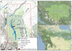
The study area is in west-central British Columbia on the title lands of the Tŝilhqot’in National Government. This area is located in the Chilcotin Plateau and is part of the Cariboo Forest Region. Elevations of the plateau are generally between 900-1500 m, with some peaks rising to elevations of 2700 to nearly 4000 m. The region includes many ecologically important water features, one of which is the Chilcotin watershed that has four essential fisheries, including major sockeye salmon runs. It has an impressive diversity of wildlife, including Canada’s largest population of bighorn sheep, rare white pelicans, bears, lynx, wolves, mountain caribou, and hundreds of wild horses.
Chapter 1:
Goal: Model spatial and temporal changes in BEC zones using the TWDTW method and Landsat imagery to determine the temporal patterns of BEC zones and subsequently classify ecosystem change through time.
Overview: In this chapter, we describe a modelling approach for examining changes in Biogeoclimatic Ecosystem Classification (BEC) classes across a study area (approximately 5,892 km2) in west-central British Columbia (BC), Canada. This region embodies various BEC zones and represents a mosaic of ecosystems influenced by natural and anthropogenic disturbance. We combine the time-weighted dynamic time warping (TWDTW) method with Landsat time series data to model the spatiotemporal landscape dynamics of BEC zones in the study area from 1997-2019 (Maus et al., 2016; Mosomtai et al., 2020). We use six Landsat reflectance bands (green, blue, red, NIR, SWIR1, and SWIR2) and Landsat-derived NDVI, NDPI, and Normalized Burn Ration (NBR) spectral surfaces to inform our TWDTW modelling. We address the first objective (O1) of our research via two related sub-objectives. The first sub-objective (O1a) develops a remote sensing time series to discern phenological temporal patterns in BEC Zones across the study area from 1997-2019 and quantify landscape dissimilarity. The second sub-objective (O1b) produces BEC land cover classification maps for 1997, 2009, and 2019, where 2009 is a midpoint in the study period, using the TWDTW method, the outcomes of which will inform Chapter 3. The outcomes of this chapter demonstrate the utility of the TWDTW method and remote sensing data for quantifying and visualizing complex spatiotemporal patterns of change and informing landscape management and conservation strategies.
Chapter 2:
Goal: Model the influence of spatial and temporal changes in ecosystem cover on the landscape connectivity of moose (Alces alces) using circuit theory implemented in Omniscape.jl.
Overview: This chapter models omni-directional landscape connectivity across a broad spatial extent (approximately 5,892 km2) in west-central British Columbia (BC), Canada using TWDTW Biogeoclimatic Ecosystem Classification (BEC) maps and resistance features (i.e., roads, water, elevation). We model landscape connectivity for three study years, 1997, 2009, and 2019 to compare connectivity through time. Our landscape connectivity approach is based on the principles of circuit theory applied in the Julia programming language using the omni-directional iteration of Circuitscape, Omniscape.jl. We apply parallel processing to model potential moose (Alces alces) movement across the study area. Moose are the focal species in this research due to their status as a declining large mammal species in BC and the species importance to the Tŝilhqot’in National Government (TNG), whose title land spans 1,765.54 km2 (~30%) of the study area and rights areas cover 3,574.9 km2 (~60.7%) of the study area. Using the Biogeoclimatic Ecosystem Classification (BEC) classification maps produced in the second chapter of this research, we present a method for modelling how temporal changes in ecosystems influence moose movement. Understanding the influence of ecosystem change on moose movement is necessary to protect populations and target conservation strategies (Feng & Li, 2020). Here we address the second objective (O2) of our research via two linked sub-objectives. The first sub-objective (O2a) develops a resistance surface representing landscape resistance to moose movement. The second sub-objective (O2b) models moose landscape connectivity for three study years, 1997, 2009, and 2019, using Omniscape.jl. This chapter demonstrates the relationship between temporal changes in BC ecosystems and corresponding alterations in landscape connectivity for moose.
Related Research:
https://conservationcorridor.org/
https://circuitscape.org/pubs/McRae_2006_IBR_Evolution.pdf
https://journals.plos.org/plosone/article?id=10.1371/journal.pone.0162989