
The Salmon River watershed is located in the Township of Langley, east of Vancouver, B.C. The watershed consists of both urban and rural settings. It originates from Aldergrove and moves across the Hopington aquifer, in the Lower Fraser Valley. It is estimated to be 150 km long, covering approximately an area of 80 km2, and an elevation variation of about 400m to 1200m. Salmon River Watershed drains into the Fraser River Basin and stretches from Abbotsford. In Langley township, more than half of the population relies on groundwater supplies (Stewardship Center for British Columbia). Levels of groundwater have been declining during the past 40 years mainly due to unregulated withdrawals, where any person can extract as much water as needed without penalties.
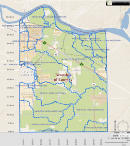
Location of the Salmon River watershed in Township of Langley (Source: https://crcresearch.org/case-studies/crc-case-studies/salmon-river-watershed-management-plan)
The major land uses in the watershed are agriculture and urban. These two relies on groundwater for the majority of their needs. The Hopington aquifer, is the major aquifer in the watershed, it is essential for maintaining the stream flow and productivity of the Salmon River. Additionally, it supplies water for over 60% of areas’ population and supports over than 4000 residences and 500 farms (Ling & Harris, 2007).
Groundwater recharge is the entry of water from the unsaturated zone into the saturated zone below the water table as well as flow of water below the water table to an open water body such as river, lake or an ocean. There are different pathways by which groundwater below the table is recharged which first include the infiltration of received rainfall into saturated zone, percolation across the soil layers and finally enters into the water table. There are different factors which influence water movement across the soil profile into the water table within a watershed including soil type, land use/land cover, slope, drainage, and flow accumulation of the main stream. Drainage density is used to represent the drainage of the watershed which is the total length of the stream and its tributaries over the total area of the drainage basin/watershed. The drainage network helps us to evaluate the characteristics of the groundwater recharge zone and this depends on the River’s flow accumulation and soil types with different permeability rates. Land use helps to understand the groundwater budget to different activities and their influence on the infiltration capacities. Slope speaks to the storage from infiltration and if the gradient is high there is less infiltration and vice versa.
Remote sensing techniques help in classifying the land use and cover of a particular area and it is increasingly applied in so many studies (Yeh et al., 2016). This technology uses aerial photos taken from past years in order to observe the changes in land use. Thematic map layers for each factor was developed in ArcGIS and eventually a final map showing the groundwater recharge potential zone was developed by assigning weights to different factors depending on their degree of influence to groundwater recharge.