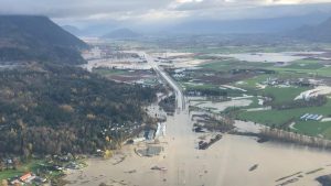
In November, Southern British Columbia was hit by a devastating atmospheric river that generated massive torrential downpour. Cities like Abbotsford saw a record breaking amount of a total of 540mm of precipitation in November resulting in many areas being completely flooded and the shutdown of major highways [6]. In our analysis, we attempt to map areas along the Fraser river and surrounding water bodies along the Fraser River to determine areas that would be inundated at various increases in water levels simulating storm events. The process involved interpolating flooding elevations using elevation of from water bodies obtained from high resolution lidar data [1]. Through taking the difference between topographic elevation and flooding elevation, we were able to effectively map areas that would be flooded at various increases in water levels. Our results showed that areas around the Nicomekl and Serpentine river in south Surrey, and the Trans Canada Highway between Chilliwack and Hope experienced most severe flooding. Therefore, dikes in those areas should be replaced or upgraded in order to better protect those areas.