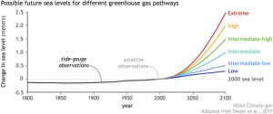
Relating to recent news, areas along the Fraser specifically from Abbotsford to Hope were heavily flooded in November of this year. Many sections of Highway 1 and 7 were deemed inaccessible due to the flooding. No maps have been found to show the specific areas flooded so a direct comparison with this project is not possible. However, the general areas affected do coincide with the areas projected in this project, that being from Abbotsford to Hope. The flooded area in South Surrey projected in this project was not part of the flooding event in November which makes sense as the flood was generated mainly through heavy rain storms that had a stronger presence near mountainous regions such as the inner Fraser. The area in South Surrey is still prone to flooding but it would mainly be due to sea level rise as the Nicomekl and Serpentine rivers (main source of flooding in the area) are directly connected to the Pacific. Given that the current global trend of climate change almost guarantees an increase to the sea level in the upcoming decades, the area around South Surrey is in danger of flooding should sea levels rise whether it be gradual in the upcoming decades or sudden, during a Pacific storm event [7].
Recommendations
Using the the outputted maps delineating the areas flooded, we recommend potential dikes to be constructed or existing dikes to be upgraded in the following areas:
- The area around the Nicomekl and Serpentine river in south Surrey
- Trans Canada Highway between Chilliwack and Hope
- Along Chilliwack River near the city of Chilliwack
- Along the river that runs through the Sumas Prairies
Limitations/Errors
One of the biggest limitation in our analysis was that we set out arbitrary uniform 1m and 2m increases in water levels in rivers inside our area of interest. This was meant to simulate a potential increase in precipitation, however, we were unable to obtain an accurate estimate on the amount of precipitation required to raise river levels to a 1-2m increase. Another limitation in our model is in our construction of the surface water elevations (flooding elevation). In our approach, we interpolated points based on the closest known flooding elevation which may differ from the actual flooding elevation at that location. Since we weren’t able to obtain a cross-section data which would have provided better estimates for the flooding elevations, the elevation values that we interpolated may not be representative of actual flooding heights in real life. Moreover, water levels would not be risen uniformly along the Fraser and other tributaries. In addition, our water bodies layer did not include smaller streams and lakes which may result in some areas not being accurately mapped. DEM resolution was a constraining factor in the precision of our study as it limited the scale and limited the resolution of our output of flooded areas. Moreover, our analysis required converting vector to raster and vice-versa which increased error in our outputs. Lastly, the DEM data used in this project was also limited as it either had outdated or inaccurate data as the elevations did not match in certain locations, especially small hills in the Lower Mainland. The projections used were confirmed to be NAD 1983 BC Environment Albers, so the inaccuracies in the DEM data were due to the quality of the dataset.
