Taking the Difference between DEM and Waterbody Elevation:
Our next step involved calculating a new field in our point layer that we created which represented the difference between the ground elevation and the flooding elevation at every point in our area of interest. The reclassify tool was then used to reclassify values with points less than or equal to zero, assigned a value of one (representing flooded areas) and everything larger than one, assigned a value of zero (representing the non-flooded areas).
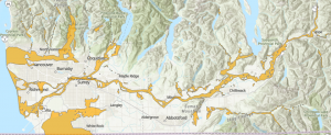
Select by Location:
The last step is to remove areas that were flooded but not connected to a river in our waterbody layer we used. This is to ensure that we only obtain areas that are flooded by a river as in our analysis we are only concerned with flooding due to water from a river. The raster layer produced is converted into polygons and using select by location we selected all areas that intersected with the river bodies layer producing a map of the flooded areas along the Fraser.