Research Goal: Identify and delineate areas in the Fraser Valley, Abbotsford and Hope that would be flooded at various increases in water elevations in the Fraser and nearby tributaries.
Study Area: Area along the Fraser River from Richmond all the way to Hope.
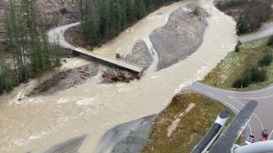
In mid November, areas in southern BC experienced record breaking precipitation resulting in the flooding of many areas along the Fraser. The atmospheric river that caused these storm events resulted in major roadways being shut down due to flooding and landslides with highway 7 and highway 1 having to be closed down [5]. The province of BC was under a state of emergency following the flooding event with even Canadian armed forces being called in to help.
The Fraser River
The Fraser river runs through much of western North America and consists of a total area of 238,000 square kilometers. It’s sourced from Yellowhead Lake in BC-AB border and runs through 1,370 km all the way to the Strait of Georgia and carries around 20Mt of sediment per year [2]. Throughout the years, there has been increasing development in areas along the Fraser and this has led to increasing risk of flooding since many of the settlements have been made on its floodplains. Therefore, our analysis aims to identify areas that are at risk of flooding in order to provide more insight on flood protection efforts.
Fraser River Flooding History
There have been past floods that have occurred in the Fraser valley and in parts of the Fraser Basin with the largest and most significant one in 1894. This occurred in May of that year which saw rapid snow melt causing river levels to increase resulting in the flooding of areas from Harrison to Richmond [4].
With climate change, we would likely see an increase in the frequency and severity of storm events in BC resulting in an increase in the number and magnitude of flooding events experienced in the Fraser Basin [4]. Therefore, mapping flood risk areas along the Fraser is being increasingly more and more relevant and essential to protecting communities from flooding.
Flood Protection
There are currently over 600km of dikes and 100 pump stations which were built to mitigate and protect areas from flooding. However, a recent study conducted on assessing dikes in the lower mainland saw only 13% of dikes being in fair to good condition with 69% being poor to fair and 18% being unacceptable [8]. Due to lack of datasets recording exact heights of dikes or flood structures in BC and a majority of dikes being outdated, we have opted to conduct the analysis without taking into account the presence of any existing dikes.