In Daniel Edelson’s definition of geoliteracy (“the understanding of human and natural systems, geographic reasoning, and systematic decision-making”) he splits it into three sections:
- Interactions (how the world works)
- Interconnections (how the world is connected) and
- Implications (How interactions and interconnections determine outcomes of actions)
On this page you can find examples of activities to use to teach “geoliteracy” (literacy of geography) to high school students. by looking at Edelson’s definition of geoliteracy.
Example activity 1: Urban land use field trip activity
The objective of this activity is to take students into their community to look at different indicators of different neighbourhoods. Students will be asked to use the “OSAE” acronym to analyze the neighbourhood that they go to.
“OSAE”:
Observe – What do you see? What’s going on? etc.
Speculate – Why is something there or not? Write open ended questions to make sense of your observations
Analyze – How come? What is the real reason why it’s here or not? Find answers to your questions.
Evaluate – In what ways could this landscape change? Consider social values, justify your opinions.
Here’s how this activity ties into aiding geoliteracy:
- Interactions: looking at the neighbouring communities to see what is there in the area (e.g. restaurants/businesses)
- Interconnections: looking at how that area interacts with neighbouring area and the rest of the world (e.g. bus routes) and
- Implications: what conclusions can be drawn based on the looking at the community and how they interact with the world (e.g. Density of Chinese real estate agents in certain areas of BC)
Below is an example of using the OSAE analysis method, looking at the city block from West Broadway to 11th Ave., and from Alma St. to Dunbar St. in Vancouver, BC.
Observe:
Speculate:
The intersection of West Broadway and 11th brought various observations which make us question why it was location there. The first major observation was the various buses (the 14,the 99 and the 32) which indicated that this area was a major intersection that connect the West End to various locations. Whether people were going to UBC, Burnaby, Vancouver or East Vancouver, the busses indicated how important this areas is for transit purposes. The second major observation our group discovered was the diversity of houses and complexes located on the east side of Alma and those location on the west side of Alma. Both types are located there for housing purposes but the east side clearly had an affluent component while the west side, we speculate houses more students. We also observed one relator sign with writing in Chinese indicating the influence of oversea buyers. The various music/instrument stores indicates the role of music on the culture in the West End. Being a more wealthy section of Vancouver, these store show us that various stores of the same products can thrive in the same area. There were some unique observations as well such as the discover of a kiwi fruit plant which indicates the influence of foreign culture on the area and the community legion which indicates a community centred culture. This is furthered reinsured by Muffin Break and Bean Around the World coffee location where residents buy their daily morning coffee. The Browns Social House was clearly located there to indicate that this area is an up and coming area where residents can eat at a well-established/known food chain. This location also included local restaurants as well which indicates a community based culture. Overall, our group speculate that this area will continue to grow and change in the next few years and it will be interesting to re-examine this area as our city continues to evolve.
Speculation Questions:
- How can this area deal with the expanded population in the next ten yearsHow has this area changed through time?
- Based on the changes that have happened, what could we speculate how the area will look like in the next ten years?
- How will the transit system expand or decline in the area in the next ten years?
- Based on our observations, how can community based businesses survive the onslaught of big businesses?
- Who will own these houses in the next ten years? Will the demographic change?
- What have been real estate trends in the last 10 year? What are the current projections on real estate in the area in the coming years? Will it be more owned property or rented/leased property?
- Based on the above projections what socioeconomic group could be the controllers of the area?
- What other phenomenons have occurred in surrounding areas?
Analyze:
Our exploration from W Broadway to W 11th took us through what seemed to be different socio-economic environments. Throughout our walk we saw different forms of housing. We saw some ‘old looking’ three to four story apartment buildings, we saw some houses that were subdivided into numerous apartment suits, we also saw some ‘expensive looking’ private houses with a traditional North American look where white fences and beautiful front yards were noticeable. One may ask, why such a variety in regards to housing? Well, the proximity of the location to the University of British Columbia (an expensive and prestigious university) attracts home buyers that can afford to live close to the university, thus are able to buy the expensive houses. It is important to note that the house near UBC are some of the most expensive in the province. However, we also saw more affordable looking homes, previously stated as ‘old looking’ homes. Why does cheaper housing exist in this location? The fact that the university is really close by means that students who are not able to work have to also be able to afford somewhat cheaper living if they are not able to afford the expensive rooms in the university campus. The small subdivided houses that are turned into small apartment units allow students to rent at a cheaper rate and also allows landlords to make a profit because they are renting out multiple units in the same residence. During our exploration we did not observe many name brand stores. To be precise, we only observed one name brand restaurant, Browns Social House. We were surprised when we saw this restaurant because it did not fit in the plaza. The restaurant was much smaller than in other locations such as in Burnaby and Coquitlam. In retrospect, we also noticed a lot of small businesses in this area. This may be the case because of the uniqueness of the social construct of the area. We also notices a lot of music stores such as guitar stores. We do not know exactly why this may be the case, but we believe that due to the close proximity to UBC, the music stores allow students, more specifically music teachers a close location to purchase music instruments.
Evaluate:
The area itself as stated in the analysis was not entirely homogenous in the sense that it was not one particular type of house or business. In our observations we noticed that there were many different small businesses with the lack of larger multinationals being awfully surprising. However, as mentioned before an out of place Browns Social House seemed to change the dynamic of an otherwise small business dominated area. This demonstrated that the beginnings of a gentrification/commercialization of the area was occurring, interestingly enough this was corroborated by the disconcerting fact that the “Muffin Break” was to soon become an A&W. This obvious gentrifying of the area was reflected also in the building of new more expensive houses that is clearly not intended to house middle income families or students. The idea that this area was to house more wealthier people, whether they be wealthier families or students was abundantly clear. The area was dominated by non-affiliated coffee shops and music stores which to us demonstrated a laid back more familial vibe rather than the cosmopolitan-esque Browns Social House that seemed to be an isore and not intended for the local inhabitants. Therefore, the gentrification of this neighbourhood of Kitsilano seemed to reflect that immigration of wealthier business oriented peoples. In other instances we noticed that a new property development was next to an old rickety pink coloured house that looked subdivided. Our group felt as though this type of property was already an outlier in an area populated with well to do business types, to keep its character a place like this would have to slowly change or become obsolete. Our group felt the same way about the music shops in the area, as the neighbourhood became economically wealthier, would these shops be necessary. It felt as if they were a remnant of a time past in which the area had seen artists such as Hendrix and Morrison pass through, now seems to be a time of richer families unaffiliated to the area and wealthy students who wanted to live off campus.
Example activity 2: 5 themes of Geography
This activity can work in conjunction with the Urban Land Use activity as the introduction to what geography is. This teaches students to look at different aspects of geography by picking a different locations that they associate in their life.
The link below is an example of this activity being done on UBC campus.
Example activity 3: BRICS/MINT PEEPS poster activity
Looking at PEEPS (Physical, Economic, Environmental, Political, Social) interactions between BRICS (Brazil, Russia, India, China, South Africa) and MINT (Mexico, Indonesia, Nigeria, Turkey) with Canada. Teachers can teach different aspects/types of geography.
How this activity relates to geoliteracy:
- Interactions: looking at how different countries are similar and different from each other (e.g. population, produce, land mass, etc.)
- Interconnections: looking at how different countries also interact with each each other (e.g. trade, export, import, immigration, etc.) and
- Implications: looking at what conclusions can be drawn based on the similarities, differences and interactions
Below is an example of the comparison between Brazil and Canada.

Example activity 4: Information Graphic Activity
This activity can be used in conjunction with the BRICS/MINT PEEPS poster activity. This can be an introduction to that activity by looking at an individual country before looking at the relationship between Canada and that individual country.
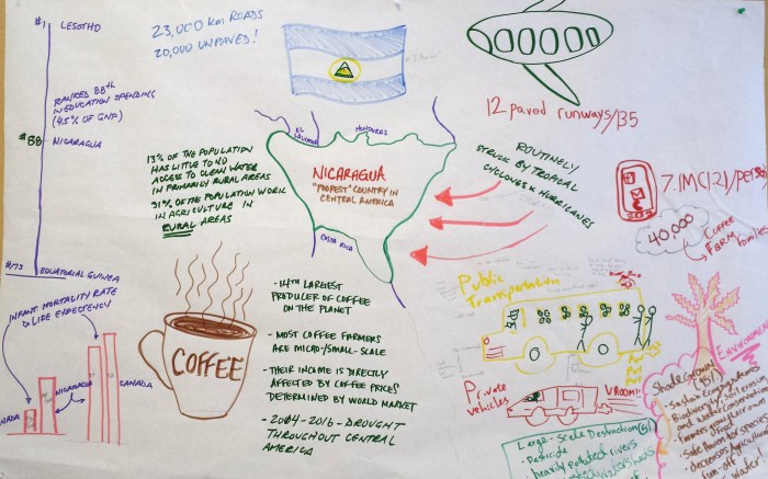
Students can examine the impacts of developing countries relying upon one mono culture crop as a major source of export income. We’ll be in the library today to gather data on an export crop where you are going to create your own info-graphic on one of the following resources/topics: Bananas, Coffee, Cocoa, Cotton or Tobacco. The end product will be a hard copy poster that shows the devastating effects of a developing country relying on one mono culture agricultural crop for the majority of its income.
Below is an example of using coffee to look at Nicaragua.