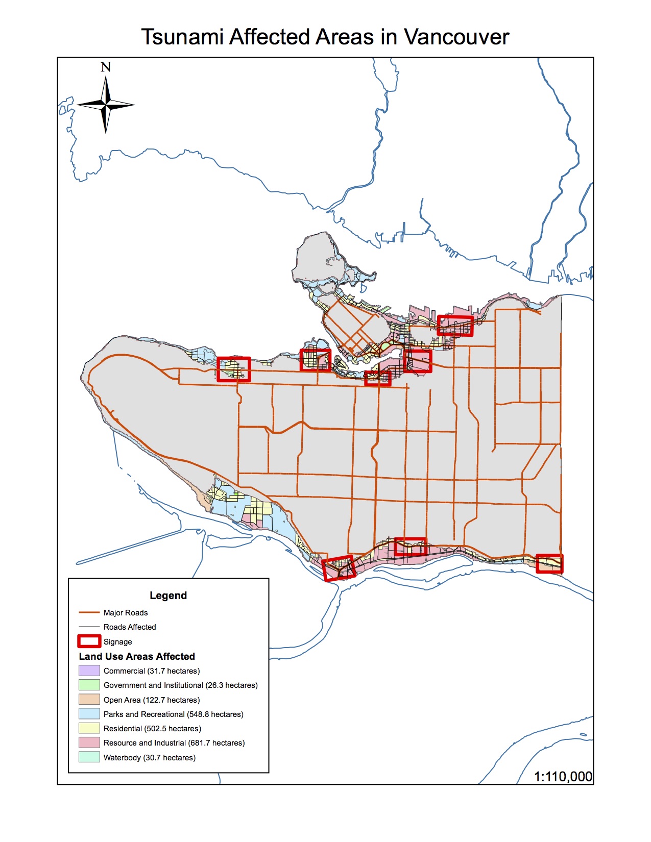
 In the event of a tsunami, approximately 1.38% of Vancouver’s total area will be in danger. To get the percentage of Vancouver’s total area in danger, I summed up all the areas in danger (I got 1807225.594473 m2) and then I got the City of Vancouver’s total area from the “Vancouvermask” (which was 131033339.950334 m2). I divided the amount of area in danger by the total area in the City of Vancouver (1807225.594473 / 131033339.950334) x 100% and I got 1.38%.
Healthcare facilities in the Vancouver danger zone: FALSE CREEK RESIDENCE, VILLA CATHAY CARE HOME, BROADWAY PENTECOSTAL LODGE, YALETOWN HOUSE SOCIETY.
Educational Facilities in the Vancouver danger zone: EMILY CARR INSTITUTE OF ART & DESIGN (ECIAD), INSTITUTE OF INDIGENOUS GOVERNMENT (IIG), HENRY HUDSON ELEMENTARY, FALSE CREEK ELEMENTARY, VANCOUVER MONTESSORI SCHOOL, HERITAGE 3R’S SCHOOL, ST ANTHONY OF PADUA, ECOLE ROSE DES VENTS.
To get to my answer, I went into the Arctoolbox function under Analysis Tools, clicked on intersect, and put in “Education” and “Vancouver_Danger” into the input features. This would find the points of education that intersect with/fall in the Vancouver danger zone. Then I pressed “ok” and named it Vancouver_education. I then re-did it for the healthcare data. After I got the points of educational facilities and healthcare facilities that are in the Vancouver danger zone, I checked their attributes table by right slicking on the layer to find the names of these facilities
SKILLS ACQUIRED
- Used my knowledge of GIS software and applications to describe data integrity and ethical implications for maps
- Managed and changed data projections in order to fix misaligned and improperly referenced data
- Conducted a basic geographic analysis involving buffers and reclassification on the City of Vancouver to determine areas vulnerable to possible tsunamis