April 3rd, 2017 update:
Well….. I checked again after Prof. Hermansen tried to show us the news but was told by the class that this news was an April Fool’s joke… It was indeed a joke…
——————————————————————————————–
April 2nd, 2017 update:
I just saw a news about this site’s future development plan as the first Disney ski resort yesterday. I was so surprised to be informed by the news that this site’s environmental assessment was finally approved by the government in 2016. Seeing the news after doing my own environmental assessment of this site creates an intimate sense of place and establish a bond between me and the previous unfamiliar site. It is really practical to learn the GISystem, GIScience, and use the ArcGIS program to do real world case studies and analysis.
Here is the link to the news:
http://dailyhive.com/calgary/disney-ski-resort-squamish-vancouver-canada
——————————————————————————————–
- Proposed Project
The proposed project is a year-round destination mountain resort on Brohm Ridge, which is 80km from Vancouver and 45km south of Whistler. This project was criticized by the BC environmental assessment office, saying that information about the potential risk for the local vegetation, fish habitats, and other ecosystems are not being appropriately valued. I act as a natural planner hired by the project proponents to evaluate the vulnerable regions of this site and make recommendations to the developer about how to preserve the local habitats and ecosystems while successfully developing the ski resort; only after a comprehensive assessment of the environmental impacts, the project could proceed in the future.
- Analyze steps
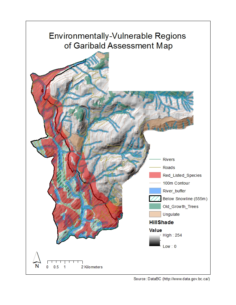
I collected the data of rivers, roads, terrestrial ecosystems, old growth trees, ungulate, and elevation from the statistic Canada website. By creating a geodatabase, I put all the datasets pertinent to the study as mentioned above. This helped organize and manage the information through all my layers. Once my relevant layers are imported into the ArcGIS, I cut my data to fit the study region since my focus is this ski resort’s local impact. I applied different tools to represent the data that I believe is important in respect of environmental protection: red-list species of all terrestrial creatures inside the site boundaries; old growth forests in this region; ungulate’s winter activity regions; areas below the snow-line (555m), which is not suitable for development of the ski routes for its low-depth snow cover; varying stream buffer zones (100m adjacent the river below the snowline; 50m above the snowline) that vary due to the different amount of fish habitats in different elevations: more fish activities below the snow-line and less above. Finally, the sum of all the areas of wildlife, fish and vegetation protection areas was calculated; I improve the basic representation to make the map clearer and more visually engaging.
- General Results
In my analysis, I find about 53% area of the total project area is environmentally sensitive and should be under protection.
The respective areas should be under protection are illustrated in detail below:
Old growth forest: 6.8%
Ungulate (Mule Deer and Mountain Goat): 7.9%
Red-listed species: 24.8%
River buffer (for fish bear stream and riparian ecosystem protection): 26%
Furthermore, 30% area is below the snowline and does not have enough snowfall for the ski development.
- Environmental Concerns
In my opinion, the two greatest environmental concerns to this project’s development are:
- The development area of this site for ski resorts may overlap some wildlife habitats and other ecosystems. Once these regions are disturbed, they are extremely difficult to be restored and the associated ecosystem services are destroyed.
- Although human infrastructures may not overlap some wildlife ecosystems, the potential noise, air, light, etc., pollution may put animals in danger. Large animals, as urban avoiders, may be extruded by human activities from this region; small animals like mice act as urban exploiters to exploit human waste and living environment. In this case, human activities may strongly disturb with the original local special ecosystem and may have unknown and irreversible effect.
- Mitigation ways
However, I do find that as seen in the final map produced for this study, most of the protected areas are concentrated within the region below the snowline, which has been deemed not suitable for ski routes development, as well as around the edges of the project area boundary, which links to the provincial park (not allowed for development). Meanwhile, the significant amount of existing road networks in this region serves well for the construction and the resort’s daily use, minimizing the need for new infrastructure redevelopment.
Therefore, by concentrating the new ski resort development on the above-snowline centre area of the region as well as planning buffer zones for all the sensitive habitats and promoting sustainable design, we could minimize human impacts on this region and achieve a well-balance with the original wildlife habitats. More assessments and research about the local wild species’ diet, habits, hunting regions, etc. are in need.
All in all, even though the initial environmental concerns identified by the Resort Municipality of Whistler and the BC Environmental Assessment Office are legitimate concerns that must be recognized and mediated, I recommend that pending mitigation strategy analyses the proposal for the Garibaldi at Squamish Ski Resort be approved.
- Ethical concerns
When I firstly got the result that over half of the region are not suitable for human infrastructure development, I personally think the project should not be allowed to continue since we must acknowledge and preserve the ecosystem services other species provide to the whole biosphere. Meanwhile, humans have moral obligation to protect other species. But as an environmental planner who was hired by the project proponents, it is my responsibility to discover the positive side of the ski resort development to this region. This obligation drives me to find the pattern that most of the environmentally important regions are located below the snowline, which coincides the inappropriate regions for ski resort development. That’s to say, developing this site does not
But as an environmental planner who was hired by the project proponents, it is my responsibility to discover the positive side of the ski resort development to this region. This obligation drives me to find the pattern that most of the environmentally important regions are located below the snowline, which coincides the inappropriate regions for ski resort development. That’s to say, developing this site does not mean significant impacts to these sensitive species considering protective buffers would be constructed in the future. This experience of ethical conflict makes me aware that every coin has two sides; I may unravel evidence contradictory to my former conclusion after some efforts.
- Learning outcomes:
I learned the 7 steps of visualizing data in this lab project and used the first 5 steps to manipulate my data representation:
- Acquire – obtain the data
- Parse – provide some structure and order for the data
- Filter – remove all but the data of interest
- Mine – apply methods to discern patterns or context (ArcGIS analysis tools)
- Represent – choose a basic visual model
I produced a map and make interpretations and personal opinions on a contentious development project near Squamish, BC that is currently under Environmental Assessment review to assess its potential environmental and economic impacts.