Environmental Assessment
Environmental Assessment of Potential Squamish Ski Resort
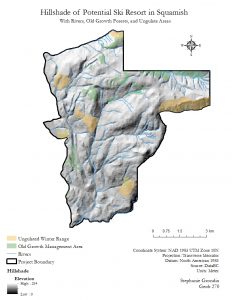
Hillshade of Potential Ski Resort in Squamish
Environmental Assessment Memo:
As a natural resource planner hired by the project proponents, I am in charge of evaluating criticism and deciding what issues need to be addressed, along with issues that can be considered to be minor, in order for the Garibaldi at Squamish potential Ski Resort on Brohm Ridge to proceed with their proposal. Economically, the resort would provide great profit to the town of Squamish through a boost of tourism and commercialization. Even though ecologically the ski resort could have potential effect on the wildlife and habitats that exist in the project boundary area, there is possibility of working around the protected areas. I am here to assess issues that could arise from the potential ski resort and the priorities need to be taken to move ahead with the project proposal.
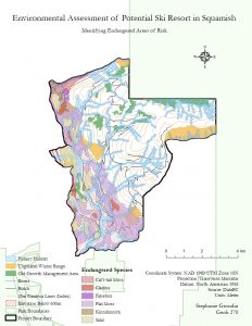
In order to analyze the data, I created two maps with ArcGIS that visualize any endangered and protected areas within the project boundaries. I obtained my data from DataBC and BC Government TRIM Data. In my findings, I calculated the total area percentage of each protected zone by dividing their total areas by the total project area, in which the totals of each area were located in the layer’s attribute tables.
To start with, I found 31.79% of the project is below the 600m elevation marker. This means approximately 32% of the land has a higher likelihood of not receiving enough snow, which would result in poor skiing conditions and would reflect badly on the ski resort. Another issue that could arise in the future is that this elevation marker could potentially increase each year with the warming of the globe due to climate change. This would result in the area that fails to receive enough snow to expand to cover a greater area of the total project zone, indicating less snow for the ski resort. However, the ski resort can benefit from the lower elevation by using the land as the base for the ski resort, to construct buildings and the loading zones for ski gondolas. It could also include parking, commercialized businesses, and hotels.
The next protected area includes Old Growth Forest cover and Ungulate habitats, which include Mule Deer and Mountain Goats. Old Growth covers 6.78% of the proposed project land, and the ungulate habitats covers 7.89% of project land, with Mule Deer covering 4.24% and Mountain Goats covering 3.65%. While these areas are restricted from the resort, they only cover a small portion of the total area. In addition, the layers overlap in some regions, thus reducing the total unusable land, with some of the areas located in the 600m lower elevation.
Endangered or threatened species covers 24.83% of the area within the project boundary. These red-listed ecosystems located within the project boundary include Falsebox, Salal, Cladina, Kinnikinnick, Flat Moss, and Cat’s-tail Moss. Flat Moss is the most dominant endangered species within the project boundaries. However, the habitats of endangered species are unpredictable as it can easily expand or decrease in their area size.
Fish habitat covers 28.43% of the proposed project land. I created a Buffer on the rivers, with a 50m buffer on streams located above 600m and a 100m buffer on streams located below 600m. Even though the boarder to the streams in the lower elevation have a larger buffer, it does not affect the ski runs as they are below the 600m vertical below the snowline. The 50m buffers in the higher elevations allow the maximization of land use area for the potential ski resort.
Overall, 53.70% of the proposed Ski Resort project area would be part of either an endangered species habitat, below 600m elevation of the snowline, old growth forest, ungulate region, or in fishery habitats. Only just over 50% of the land cover is found in a protected ecosystem, meaning there is still space in the other 50% of the land that is usable for the proposed ski resort. There is an open area located in the middle of the proposed ski resort as the best area for ski runs. The elevation is above the snowline, indicating good skiing conditions, and few endangered species or protected areas would not be disrupted. One challenge would be navigating around the network of rivers, but it’s possible to design and maneuver ski runs around the steams. Another challenge would occur in the lower 600m elevation, where a large portion of land is covered by endangered species. The ski resort would be able to work around these restrictions, as commercialization of place would not need large amounts of land area as ski runs would need. In conclusion, while the data presents significant impediments, this project presents great promise for the construction of a ski resort that does not disrupt natural ecosystems.
Reflection on Environmental Assessment:
Upon completion of the 2 maps and the memo based off the assumption I was a natural resource planner hired by the Ski Resort proponents to do an environmental assessment, I personally would not ethically believe that this project should continue forward. Even though the map displayed a potential area for development of the ski resort in the middle zone, because more than half of the project land is in protected area, I believe the ski resort would likely cause destruction of these endangered zones. It would be challenging for the ski resort to develop around the natural ecosystems, and further development of the ski resort could result in harmful effects, such as heavier pollution or preventing the endangered species habitat from expanding. In conclusion, for this particular project, I would be ethically against the construction of the ski resort, which would differ from the memo I created that had a biased inclination towards the building of the ski resort.