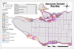
Percentage of City of Vancouver’s Total Area that is Affected by a Potential Tsunami
16% of the city of Vancouver would be in danger if there is a tsunami hits. To calculate this, I found the areas of ‘Vancouver_Danger’ and ‘Vancouvermask’ layers by going to their attribute tables respectively. Thus, I calculated the geometry of the area in square meters.
Total danger area of Vancouver =20302078.291704 meters – Summing up the category of ‘Sum of Danger Area in m2’ from table above
Total area of Vancouver =131033339.950334 meters – Going to the attribute table of ‘Vancouvermask’ layer in ArcMap
Percentage of the city of Vancouver total area affected by potential tsunami= (20302078.291704/ 131033339.950334) x 100%= 15.49383% ~ 16%
Education and Healthcare Facilities that are Affected by a Potential Tsunami
In order to find these facilities, I used Intersect tool in ArcToolBox, going to Analysis Tools > Overlay > Intersect. Then, I combine the ‘Vancouver_Danger’ layer with the ‘Vancouver_health’ and ‘Vancouver_education’ layer separately. Then, I opened the Attribute tables of the two newly intersected layers to see the names of the healthcare and education facilities that could be affected by a potential Tsunami. Here are the list of the education and healthcare facilities within the Vancouver Danger Zone:
Education facilities within the Vancouver Danger Zone:
- ST ANTHONY OF PADUAECOLE ROSE DES VENTS
- HERITAGE 3R’S SCHOOL
- VANCOUVER MONTESSORI SCHOOL
- FALSE CREEK ELEMENTARY
- EMILY CARR INSTITUTE OF ART & DESIGN (ECIAD)
- HENRY HUDSON ELEMENTARY
- ST JOHN’S INTERNATIONAL
- ST FRANCIS XAVIER
- INSTITUTE OF INDIGENOUS GOVERNMENT (IIG)
Healthcare facilities within the Vancouver Danger Zone:
- FALSE CREEK RESIDENCE
- BROADWAY PENTECOSTAL LODGE
- COAST WEST COMMUNITY HOME
- YALETOWN HOUSE SOCIETY
- VILLA CATHAY CARE HOME