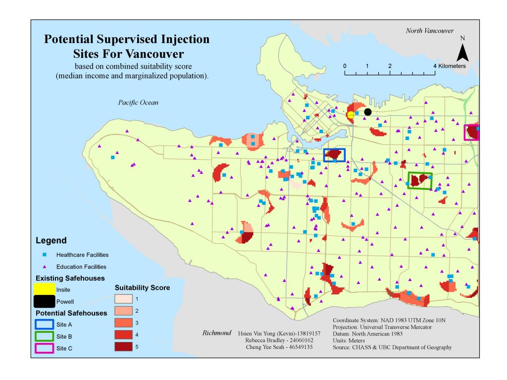
In our project, we decided to provide new locations on where to build a new safehouse for drug users in Vancouver, British Columbia. Due to constraints (lack of data on overdose locations), we determined income and marginalized communities (including First Nation communities and minority groups) as the two most relevant factors for involvements with illegal drugs, hence increasing association and likelihood of drug overdoses. Furthermore, we chose our locations based on being within a 500m radius of a healthcare facility and at least 500m away from any educational institutions. From our results we chose three suitable sites, Site A to Site C where Site A being the most suitable out of the three. Our goal was to provide a new safehouse to help protect this vulnerable population from spreading diseases, and dying due to overdose as safehouses can act as a lifeline for these. However, we do not hope for safe houses to become the sole solution to this growing epidemic.
In terms of project management, I have organized our team and distributed the different tasks, and made sure that the work was divided up evenly. Furthermore, I have provided my insight and guidance throughout the whole group project. I have learned a lot about the ways in city of Vancouver are managing the drug situation in Vancouver as there are already two safehouses which are Insite (the first legal supervised drug injection site in North America) and Powell Street Gateway, and there are many drug support groups in Vancouver which are free of charge. Overall, I was pleased that I developed a better understanding on how a developed city such as Vancouver is taking different approaches towards drug issues such as providing supervised injection sites.
Doing this project taught me some interesting GIS analysis techniques, such as doing weighted sum analysis where I sum up the three data layers (income, minority groups and First nations, which all had a rank of 1 to 5 where 5 is the most suitable for our project) to obtain a spatial layer where there are scores ranging from 3 (minimum score which was the least suitable) to 15 (maximum score which was the most suitable). This project also led me to build better teamwork skills, as well as more efficient project management approaches and techniques, such as using Google docs where I can provide my points and my teammate would help me correct and improve my sentences, instead of everyone coming up with points all at once. One of the issues we faced was to decide on which factors we should use for our analysis which significantly slowed down the first stage of our group project in data acquisition and creating the map, hence, we decided to choose our factors based on what data we could acquire from the internet through UBC Network such as CHASS Data Center, DataBC and UBC Department of Geography etc. Since there is a dearth of data regarding specific location of opioid overdoses in the Vancouver area due to privacy restrictions, we had to find other factors that are relevant in predicting where overdoses can potentially occur. “Other factors” can be a range of variables from age, gender, ethnicity, family life, support networks, income and much more. Overall, we are confident in our findings and analysis of our project, we believe that our project is exceptional as it provided new suitable locations for a new safehouse for drug users which is quite controversial as safehouses are still a highly controversial topic and could potentially create a negative stigma for a certain area. However, our findings provide a platform or guidance in which Vancouver could make a structural adjustment to help improve the quality of life for these individuals.
Our Final Project Report: Geob270 Report

Our Map: Potential Supervised Injection Sites for Vancouver