Whenever you start an ArcGIS Pro project you should always ensure that you have established a proper working environment. Most of the parameters that you should check out are found within Options, which is accessed by clicking on Project, and then on Options. Three of the elements that you should pay attention to are the Current Settings tab (Figure 1), the Geoprocessing tab (Figure 2), and the Share and Download tab (Figure 3). You should confirm the paths and Directories, and the options, in each tab in order to know where your files will be stored.
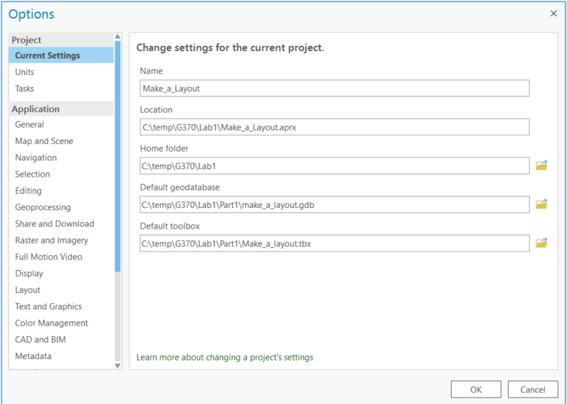
Figure 1: Options: Current Settings
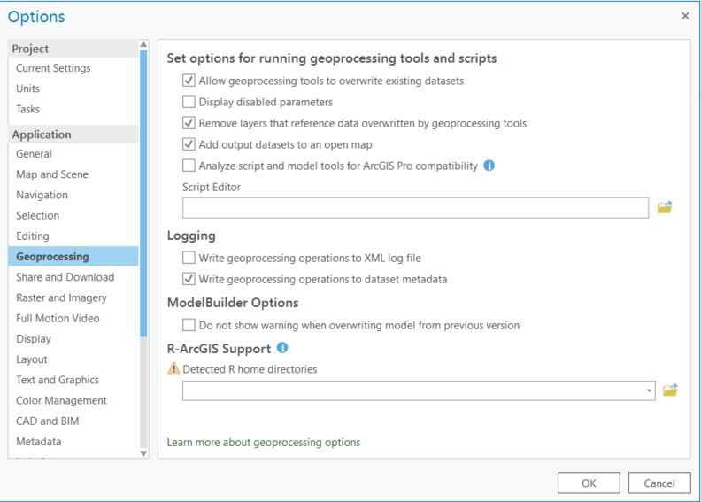
Figure 2: Options: Geoprocessing
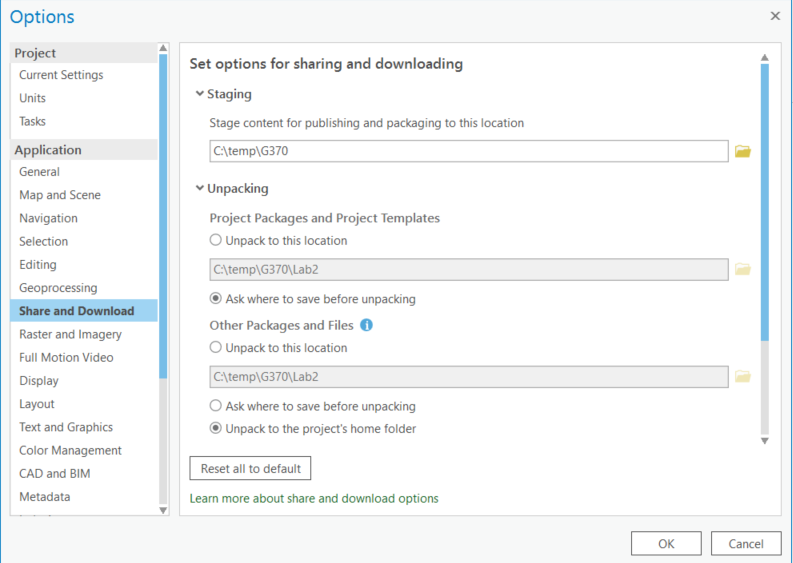
Figure 3: Options: Share and Download
Directory naming conventions
It is also a highly recommended practice to not store / create ArcMap data or documents in a directory name that contains spaces (that is, it is recommended that you do not store any files in, for example, C:\Documents and Settings\…\My Documents\ even though that is where ESRI indicates that that is where it wants to store the default geodatabase!). You should also not create files with names that begin with numbers (e.g., 123layer.shp). While it is possible to do so, and in most cases it will not create a problem, there are some known issues that arise with some components of ArcGIS Pro (and with add-on programs such as FragStats) if the directory name contains spaces / the filename begins with a number.
Show file extensions by default
It is a good practice to modify Windows Explorer so that, by default, it shows all known file extensions. To do this, click on File or Organize (depends on which Windows version you are using), then on Folder and search options. Then, in the View tab, uncheck Hide extensions for known file types. Doing this will make it much easier to find files.
Work locally
You should always work from the local (C or D) drive. We do not recommend working from or saving to the Server (H) drive. You are responsible for storing your lab data and work. Every connection to the Server ‘adds up’ and eventually the system can become very sluggish and, at the extreme, some users may find that they cannot successfully log onto the system. An example of the connections that are established by a single user shows how many connections are required when working across the network. Having too many Folder Connections can also become problematic since ArcGIS Pro will attempt to connect to the folders (even if they don’t exist), which can slow down things.
Bookmarks
Bookmarks are an efficient means of keeping your layouts consistently ‘laid out’. The ArcGIS Pro help file explains how to create and manage bookmarks.
ArcMap-related Comments
Most of the material below relates to ArcMap, not to ArcGIS Pro. However, since some people may still be using ArcMap, I will keep them up for the next year.
Absolute and relative paths
When you create an ArcMap document, you should specify that paths be stored as relative paths. To set this option, look under the File menu and click Map Document Properties. Here, you can specify whether to store absolute or relative paths.

When you save the document with relative paths, the application converts paths into paths relative to the location where you stored the document (e.g., the current directory [D:\G37x\], where x would be 0 for 370, 3 for 373, etc.).
This is especially important if you use an external storage device (e.g., a USB drive).
Setting the location for the default geodatabase
ArcMap, by default, will store any newly created files in a default geodatabase (C:\Documents and Settings\…\My Documents\ ArcGIS\Default.gdb). Since storing data in the default geodatabase location is problematic (e.g., doing so will increase the length of time it takes you to log onto the system), you should always identify an appropriate location for the geodatabase.
Given the practice in most geoscience labs in the Department of Geography, the appropriate location for storing your data / creating a geodatabase is D:\G37x\. Thus, your first step whenever starting a project / lab is to set the default database to reside in D:\G37x\Labz (where z would be the lab # and x is the course #). So, if you will be working with a geodatabase, follow the instructions listed below:
Ensure the default geodatabase is explicitly set:
- Click on Catalog
- Select Folder Connections
- Confirm that D:\G37x\Labz is listed as a Folder Connection
- Right-mouse click on the appropriate .gdb
- Click on the entry ‘Make Default Geodatabase’
It is a good idea to keep the number of connections in ArcCatalog to a minimum–every time you start ArcMap it checks the connections, and if some of them don’t exist (e.g., files on a network drive that isn’t currently connected) it can take some time for ArcMap to ‘drop’ the connection.
Establishing meaningful geoprocessing parameters
In order to ensure that subsequent steps produce the correct output, and to ensure that various outputs get placed in the correct location, we should generally explicitly set some of the geoprocessing environment options. To do this, click on Geoprocessing / Environments…
- Select Workspace and ensure that the Current and Scratch Workspaces are set to the appropriate directory / geodatabase.
- Select Processing Extent and set the Extent to an existing layer, or explicitly set the extent to something appropriate (if you have data already in the Table of Contents).
- Under Raster Analysis set the Cell Size and Mask to an existing raster layer (if you have an appropriate layer in the ToC). Click on OK. Now, whenever a feature is converted to a raster, or a raster layer is created, its resolution (and extent) will match the existing raster file.
By default ArcMap does NOT allow you to overwrite the previous outputs of a geoprocessing operation (that is, if you have to redo a geoprocessing operation you must give the output a different name). You can, however, override that default by clicking on Geoprocessing Options (under Geoprocessing) and then selecting ◙ Overwrite the outputs of geoprocessing operations.
Note: You should confirm the environmental settings / geoprocessing parameters every time you start your work.
I have observed that sometime a process, such as projecting a layer, doesn’t work if Background Processing has been enabled. You can disable background processing by deselecting it under Geoprocessing > Geoprocessing Options.
Directory naming conventions
It is also a highly recommended practice to not store / create ArcMap data or documents in a directory name that contains spaces (that is, it is recommended that you do not store any files in, for example, C:\Documents and Settings\…\My Documents\ even though that is where ArcMap indicates that that is where it wants to store the default geodatabase!). You should also not create files with names that begin with numbers (e.g., 123layer.shp). While it is possible to do so, and in most cases it will not create a problem, there are some known issues that arise with some components of ArcMap (and with add-on programs such as FragStats) if the directory name contains spaces / the filename begins with a number.
Show file extensions by default
It is a good practice to modify Windows Explorer so that, by default, it shows all known file extensions. To do this, click on File or Organize (depends on which Windows version you are using), then on Folder and search options. Then, in the View tab, uncheck Hide extensions for known file types. Doing this will make it much easier to find files.
Some general observations:
It is better to open ArcMap and then select the appropriate MXD file, rather than to double-click on the MXD file to start up ArcMap. Although in most circumstances the results will be the same, in some cases issues can arise that will subsequently result in ArcMap bombing out.
You should always work from the local (C or D) drive. We do not recommend working from or saving to the Server (H) drive. You are responsible for storing your lab data and work. Every connection to the Server ‘adds up’ and eventually the system can become very sluggish and, at the extreme, some users may find that they cannot successfully log onto the system. An example of the connections that are established by a single user shows how many connections are required by ArcMap (when working across the network). Having too many Folder Connections can also become problematic since ArcMap will attempt to connect to the folders (even if they don’t exist) which can slow down things.
Bookmarks are an efficient means of keeping your layouts consistently ‘laid out’. The ArcMap help file explains how to create and manage bookmarks.